The NR33 7 postcode sector is within the county of Suffolk.
Did you know? According to the 2021 Census, the NR33 7 postcode sector is home to a bustling 9,060 residents!
Given that each sector allows for 400 unique postcode combinations. Letters C, I, K, M, O and V are not allowed in the last two letters of a postcode. With 242 postcodes already in use, this leaves 158 units available.
The largest settlement in the NR33 7 postal code is LOWESTOFT followed by Kessingland, and Gisleham.
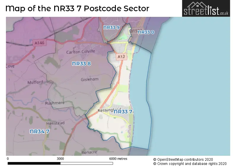
The NR33 7 Postcode shares a border with NR33 0 (LOWESTOFT), NR33 8 (Carlton Colville, LOWESTOFT, Gisleham), NR33 9 (LOWESTOFT) and NR34 7 (Worlingham, Wrentham, BECCLES).
The sector is within the post town of LOWESTOFT.
NR33 7 is a postcode sector within the NR3 postcode district which is within the NR Norwich postcode area.
The Royal Mail delivery office for the NR33 7 postal sector is the unknown.
The area of the NR33 7 postcode sector is 3.95 square miles which is 10.23 square kilometres or 2,528.01 square acres.

Map of the NR33 7 Postcode Sector
Explore the NR33 7 postcode sector by using our free interactive map.
| N | R | 3 | 3 | - | 7 | X | X |
| N | R | 3 | 3 | Space | 7 | Letter | Letter |
Official List of Streets
LOWESTOFT (68 Streets)
Kessingland (70 Streets)
Pakefield (5 Streets)
Unofficial Streets or Alternative Spellings
LOWESTOFT
LONDON ROAD SOUTH PAKEFIELD STREETCarlton Colville
FORTRESS ROAD LONG ROADWeather Forecast for NR33 7
Press Button to Show Forecast for Lowestoft - South Of Claremont Pier (Beach)
| Time Period | Icon | Description | Temperature | Rain Probability | Wind |
|---|---|---|---|---|---|
| 06:00 to 09:00 | Sunny day | 8.0°C (feels like 5.0°C) | 0.00% | SSW 11 mph | |
| 09:00 to 12:00 | Partly cloudy (day) | 12.0°C (feels like 9.0°C) | 0.00% | S 18 mph | |
| 12:00 to 15:00 | Sunny day | 13.0°C (feels like 9.0°C) | 0.00% | S 20 mph | |
| 15:00 to 18:00 | Sunny day | 14.0°C (feels like 10.0°C) | 0.00% | S 18 mph | |
| 18:00 to 21:00 | Sunny day | 12.0°C (feels like 10.0°C) | 0.00% | S 13 mph | |
| 21:00 to 00:00 | Clear night | 10.0°C (feels like 8.0°C) | 0.00% | SSE 11 mph |
Press Button to Show Forecast for Lowestoft - South Of Claremont Pier (Beach)
| Time Period | Icon | Description | Temperature | Rain Probability | Wind |
|---|---|---|---|---|---|
| 00:00 to 03:00 | Clear night | 9.0°C (feels like 7.0°C) | 0.00% | SSE 9 mph | |
| 03:00 to 06:00 | Clear night | 9.0°C (feels like 7.0°C) | 0.00% | SE 9 mph | |
| 06:00 to 09:00 | Sunny day | 11.0°C (feels like 9.0°C) | 0.00% | SE 9 mph | |
| 09:00 to 12:00 | Cloudy | 14.0°C (feels like 12.0°C) | 5.00% | SE 11 mph | |
| 12:00 to 15:00 | Cloudy | 14.0°C (feels like 12.0°C) | 6.00% | SE 11 mph | |
| 15:00 to 18:00 | Cloudy | 15.0°C (feels like 13.0°C) | 6.00% | SSE 11 mph | |
| 18:00 to 21:00 | Cloudy | 13.0°C (feels like 12.0°C) | 9.00% | SE 9 mph | |
| 21:00 to 00:00 | Light rain | 12.0°C (feels like 11.0°C) | 51.00% | SE 7 mph |
Press Button to Show Forecast for Lowestoft - South Of Claremont Pier (Beach)
| Time Period | Icon | Description | Temperature | Rain Probability | Wind |
|---|---|---|---|---|---|
| 00:00 to 03:00 | Cloudy | 11.0°C (feels like 10.0°C) | 16.00% | SE 4 mph | |
| 03:00 to 06:00 | Cloudy | 10.0°C (feels like 9.0°C) | 17.00% | SE 4 mph | |
| 06:00 to 09:00 | Cloudy | 11.0°C (feels like 10.0°C) | 12.00% | ENE 4 mph | |
| 09:00 to 12:00 | Cloudy | 14.0°C (feels like 14.0°C) | 10.00% | E 4 mph | |
| 12:00 to 15:00 | Cloudy | 16.0°C (feels like 15.0°C) | 8.00% | NE 7 mph | |
| 15:00 to 18:00 | Cloudy | 15.0°C (feels like 13.0°C) | 6.00% | NNE 9 mph | |
| 18:00 to 21:00 | Cloudy | 12.0°C (feels like 10.0°C) | 7.00% | N 9 mph | |
| 21:00 to 00:00 | Cloudy | 11.0°C (feels like 9.0°C) | 10.00% | N 11 mph |
Press Button to Show Forecast for Lowestoft - South Of Claremont Pier (Beach)
| Time Period | Icon | Description | Temperature | Rain Probability | Wind |
|---|---|---|---|---|---|
| 00:00 to 03:00 | Cloudy | 11.0°C (feels like 8.0°C) | 11.00% | NNW 9 mph | |
| 03:00 to 06:00 | Partly cloudy (night) | 11.0°C (feels like 8.0°C) | 4.00% | NNW 11 mph | |
| 06:00 to 09:00 | Cloudy | 11.0°C (feels like 9.0°C) | 7.00% | NNW 9 mph | |
| 09:00 to 12:00 | Cloudy | 14.0°C (feels like 11.0°C) | 6.00% | NNW 11 mph | |
| 12:00 to 15:00 | Cloudy | 15.0°C (feels like 13.0°C) | 4.00% | NNW 13 mph | |
| 15:00 to 18:00 | Partly cloudy (day) | 16.0°C (feels like 14.0°C) | 2.00% | N 11 mph | |
| 18:00 to 21:00 | Partly cloudy (day) | 14.0°C (feels like 13.0°C) | 1.00% | N 9 mph | |
| 21:00 to 00:00 | Partly cloudy (night) | 11.0°C (feels like 10.0°C) | 2.00% | N 9 mph |
Schools and Places of Education Within the NR33 7 Postcode Sector
Kessingland Church of England Primary Academy
Academy sponsor led
Field Lane, Lowestoft, Suffolk, NR33 7QA
Head: Mr Adrian Crossland
Ofsted Rating: Good
Inspection: 2019-12-11 (1601 days ago)
Website: Visit Kessingland Church of England Primary Academy Website
Phone: 01502740223
Number of Pupils: 228
Pakefield High School
Academy converter
London Road Pakefield, Lowestoft, Suffolk, NR33 7AQ
Head: Mr Daniel Bagshaw
Ofsted Rating: Good
Inspection: 2023-09-28 (214 days ago)
Website: Visit Pakefield High School Website
Phone: 01502530750
Number of Pupils: 687
Pakefield Primary School
Academy converter
London Road, Lowestoft, Suffolk, NR33 7AQ
Head: Mr Martyn Payne
Ofsted Rating: Good
Inspection: 2021-09-22 (950 days ago)
Website: Visit Pakefield Primary School Website
Phone: 01502574032
Number of Pupils: 363
House Prices in the NR33 7 Postcode Sector
| Type of Property | 2018 Average | 2018 Sales | 2017 Average | 2017 Sales | 2016 Average | 2016 Sales | 2015 Average | 2015 Sales |
|---|---|---|---|---|---|---|---|---|
| Detached | £245,911 | 65 | £270,565 | 65 | £238,260 | 46 | £190,498 | 42 |
| Semi-Detached | £187,510 | 59 | £178,986 | 57 | £159,324 | 54 | £145,613 | 50 |
| Terraced | £149,972 | 69 | £141,701 | 63 | £135,860 | 65 | £124,580 | 63 |
| Flats | £92,500 | 2 | £114,500 | 2 | £94,988 | 4 | £78,333 | 3 |
Important Postcodes NR33 7 in the Postcode Sector
NR33 7AQ is the postcode for Pakefield Primary School, 82 London Road, Pakefield, MAIN BLOCK, Pakefield High School, London Road Pakefield, Pakefield Primary School, 82 London Road, SPORTS BLOCK, Pakefield High School, London Road Pakefield, and EARLY YEARS BUILDING, Pakefield Primary School, 82 London Road
NR33 7DS is the postcode for Pakefield Middle School, Kilbourn Road
NR33 7HS is the postcode for Lowestoft South Fire Station, Stradbroke Road
NR33 7JS is the postcode for Stradbroke Court Residential Home, Green Drive
NR33 7NQ is the postcode for N W E S, Pinbush Road, North East Suffolk Business Centre
NR33 7QA is the postcode for Longshore Surgeries, 42 Field Lane, Kessingland VC Primary School, Field Lane, and Kessingland CofE Primary Academy, Field Lane
| The NR33 7 Sector is within these Local Authorities |
|
|---|---|
| The NR33 7 Sector is within these Counties |
|
| The NR33 7 Sector is within these Water Company Areas |
|