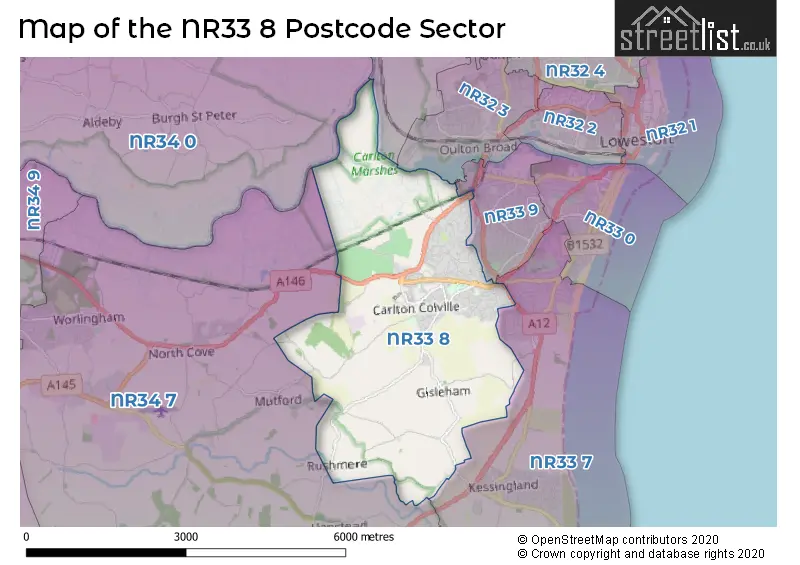
The NR33 8 postcode sector stands on the Norfolk and Suffolk border.
Did you know? According to the 2021 Census, the NR33 8 postcode sector is home to a bustling 13,090 residents!
Given that each sector allows for 400 unique postcode combinations. Letters C, I, K, M, O and V are not allowed in the last two letters of a postcode. With 297 postcodes already in use, this leaves 103 units available.
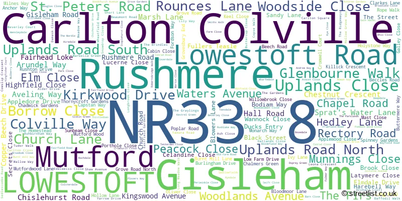
The largest settlement in the NR33 8 postal code is Carlton Colville followed by LOWESTOFT, and Gisleham.
The NR33 8 Postcode shares a border with NR32 3 (LOWESTOFT, Oulton), NR32 5 (Corton, Blundeston, Lound), NR33 7 (LOWESTOFT, Kessingland, Gisleham), NR33 9 (LOWESTOFT), NR34 0 (Gillingham, Aldeby, Toft Monks) and NR34 7 (Worlingham, Wrentham, BECCLES).
The sector is within the post town of LOWESTOFT.
NR33 8 is a postcode sector within the NR3 postcode district which is within the NR Norwich postcode area.
The Royal Mail delivery office for the NR33 8 postal sector is the unknown.
The area of the NR33 8 postcode sector is 7.58 square miles which is 19.64 square kilometres or 4,854.31 square acres.
Waterways within the NR33 8 postcode sector include the Oulton Dyke, River Waveney.

Map of the NR33 8 Postcode Sector
Explore the NR33 8 postcode sector by using our free interactive map.
| N | R | 3 | 3 | - | 8 | X | X |
| N | R | 3 | 3 | Space | 8 | Letter | Letter |
Official List of Streets
Carlton Colville (173 Streets)
LOWESTOFT (48 Streets)
Gisleham (8 Streets)
Rushmere (4 Streets)
Mutford (1 Streets)
Unofficial Streets or Alternative Spellings
Weather Forecast for NR33 8
Press Button to Show Forecast for Lowestoft - South Of Claremont Pier (Beach)
| Time Period | Icon | Description | Temperature | Rain Probability | Wind |
|---|---|---|---|---|---|
| 00:00 to 03:00 | Clear night | 7.0°C (feels like 4.0°C) | 0.00% | SSW 11 mph | |
| 03:00 to 06:00 | Clear night | 6.0°C (feels like 3.0°C) | 0.00% | SSW 9 mph | |
| 06:00 to 09:00 | Sunny day | 8.0°C (feels like 5.0°C) | 0.00% | SSW 11 mph | |
| 09:00 to 12:00 | Partly cloudy (day) | 12.0°C (feels like 9.0°C) | 0.00% | S 18 mph | |
| 12:00 to 15:00 | Sunny day | 13.0°C (feels like 9.0°C) | 0.00% | S 20 mph | |
| 15:00 to 18:00 | Sunny day | 14.0°C (feels like 10.0°C) | 0.00% | S 18 mph | |
| 18:00 to 21:00 | Sunny day | 12.0°C (feels like 10.0°C) | 0.00% | S 13 mph | |
| 21:00 to 00:00 | Clear night | 10.0°C (feels like 8.0°C) | 0.00% | SSE 11 mph |
Press Button to Show Forecast for Lowestoft - South Of Claremont Pier (Beach)
| Time Period | Icon | Description | Temperature | Rain Probability | Wind |
|---|---|---|---|---|---|
| 00:00 to 03:00 | Clear night | 9.0°C (feels like 7.0°C) | 0.00% | SSE 9 mph | |
| 03:00 to 06:00 | Clear night | 9.0°C (feels like 7.0°C) | 0.00% | SE 9 mph | |
| 06:00 to 09:00 | Sunny day | 11.0°C (feels like 9.0°C) | 0.00% | SE 9 mph | |
| 09:00 to 12:00 | Cloudy | 14.0°C (feels like 12.0°C) | 5.00% | SE 11 mph | |
| 12:00 to 15:00 | Cloudy | 14.0°C (feels like 12.0°C) | 6.00% | SE 11 mph | |
| 15:00 to 18:00 | Cloudy | 15.0°C (feels like 13.0°C) | 6.00% | SSE 11 mph | |
| 18:00 to 21:00 | Cloudy | 13.0°C (feels like 12.0°C) | 9.00% | SE 9 mph | |
| 21:00 to 00:00 | Light rain | 12.0°C (feels like 11.0°C) | 51.00% | SE 7 mph |
Press Button to Show Forecast for Lowestoft - South Of Claremont Pier (Beach)
| Time Period | Icon | Description | Temperature | Rain Probability | Wind |
|---|---|---|---|---|---|
| 00:00 to 03:00 | Cloudy | 11.0°C (feels like 10.0°C) | 16.00% | SE 4 mph | |
| 03:00 to 06:00 | Cloudy | 10.0°C (feels like 9.0°C) | 17.00% | SE 4 mph | |
| 06:00 to 09:00 | Cloudy | 11.0°C (feels like 10.0°C) | 12.00% | ENE 4 mph | |
| 09:00 to 12:00 | Cloudy | 14.0°C (feels like 14.0°C) | 10.00% | E 4 mph | |
| 12:00 to 15:00 | Cloudy | 16.0°C (feels like 15.0°C) | 8.00% | NE 7 mph | |
| 15:00 to 18:00 | Cloudy | 15.0°C (feels like 13.0°C) | 6.00% | NNE 9 mph | |
| 18:00 to 21:00 | Cloudy | 12.0°C (feels like 10.0°C) | 7.00% | N 9 mph | |
| 21:00 to 00:00 | Cloudy | 11.0°C (feels like 9.0°C) | 10.00% | N 11 mph |
Press Button to Show Forecast for Lowestoft - South Of Claremont Pier (Beach)
| Time Period | Icon | Description | Temperature | Rain Probability | Wind |
|---|---|---|---|---|---|
| 00:00 to 03:00 | Cloudy | 11.0°C (feels like 8.0°C) | 11.00% | NNW 9 mph | |
| 03:00 to 06:00 | Partly cloudy (night) | 11.0°C (feels like 8.0°C) | 4.00% | NNW 11 mph | |
| 06:00 to 09:00 | Cloudy | 11.0°C (feels like 9.0°C) | 7.00% | NNW 9 mph | |
| 09:00 to 12:00 | Cloudy | 14.0°C (feels like 11.0°C) | 6.00% | NNW 11 mph | |
| 12:00 to 15:00 | Cloudy | 15.0°C (feels like 13.0°C) | 4.00% | NNW 13 mph | |
| 15:00 to 18:00 | Partly cloudy (day) | 16.0°C (feels like 14.0°C) | 2.00% | N 11 mph | |
| 18:00 to 21:00 | Partly cloudy (day) | 14.0°C (feels like 13.0°C) | 1.00% | N 9 mph | |
| 21:00 to 00:00 | Partly cloudy (night) | 11.0°C (feels like 10.0°C) | 2.00% | N 9 mph |
Schools and Places of Education Within the NR33 8 Postcode Sector
Carlton Colville Primary School
Community school
Gisleham Road, Lowestoft, Suffolk, NR33 8DG
Head: Mr Benjamin Axon
Ofsted Rating: Outstanding
Inspection: 2011-11-29 (4535 days ago)
Website: Visit Carlton Colville Primary School Website
Phone: 01502572682
Number of Pupils: 437
Grove Primary School
Academy sponsor led
Framfield Road, Lowestoft, Suffolk, NR33 8RQ
Head: Mrs Rae Aldous
Ofsted Rating: Good
Inspection: 2022-10-12 (565 days ago)
Website: Visit Grove Primary School Website
Phone: 01502538527
Number of Pupils: 334
Warren School
Academy special sponsor led
Clarkes Lane, Lowestoft, , NR33 8HT
Head: Mr Andrew Aalders-Dunthorne
Ofsted Rating: Special Measures
Inspection: 2022-06-09 (690 days ago)
Website: Visit Warren School Website
Phone: 01502561893
Number of Pupils: 123
House Prices in the NR33 8 Postcode Sector
| Type of Property | 2018 Average | 2018 Sales | 2017 Average | 2017 Sales | 2016 Average | 2016 Sales | 2015 Average | 2015 Sales |
|---|---|---|---|---|---|---|---|---|
| Detached | £248,948 | 121 | £232,834 | 144 | £232,235 | 136 | £215,889 | 116 |
| Semi-Detached | £178,992 | 57 | £169,166 | 71 | £166,011 | 72 | £155,641 | 62 |
| Terraced | £155,908 | 59 | £144,710 | 54 | £133,943 | 63 | £127,546 | 44 |
| Flats | £114,400 | 5 | £96,333 | 3 | £116,900 | 5 | £100,900 | 5 |
Important Postcodes NR33 8 in the Postcode Sector
NR33 8AG is the postcode for CARLTON COURT, ST PETERS ROAD, Carlton Court Hospital, St. Peters Road, Norfolk and Waveney Mental Health NHS Foundation Trust, Carlton Court, SUPPORT SERVICES AND DAY HOSPITAL, Carlton Court Hospital, St. Peters Road, and ACUTE SERVICES RESOURCE CENTRE, Carlton Court Hospital, St. Peters Road
NR33 8AX is the postcode for Carlton Colville Primary School, Church Lane, and Sunrise Academy, Church Lane
NR33 8DG is the postcode for Carlton Colville Primary School, Gisleham Road, and CARLTON COLVILLE PRIMARY SCHOOL, GISLEHAM ROAD, CARLTON COLVILLE
NR33 8HT is the postcode for Warren Special School, Clarkes Lane
NR33 8RQ is the postcode for Grove Primary School, Framfield Road, and Grove Primary School, Framfield Road, Carlton Colville
| The NR33 8 Sector is within these Local Authorities |
|
|---|---|
| The NR33 8 Sector is within these Counties |
|
| The NR33 8 Sector is within these Water Company Areas |
|
Tourist Attractions within the NR33 8 Postcode Area
We found 1 visitor attractions within the NR3 postcode area
| East Anglia Transport Museum |
|---|
| Museums & Art Galleries |
| Museum and / or Art Gallery |
| View East Anglia Transport Museum on Google Maps |