The NR33 9 postcode sector is within the county of Suffolk.
Did you know? According to the 2021 Census, the NR33 9 postcode sector is home to a bustling 8,619 residents!
Given that each sector allows for 400 unique postcode combinations. Letters C, I, K, M, O and V are not allowed in the last two letters of a postcode. With 205 postcodes already in use, this leaves 195 units available.
The NR33 9 postal code covers the settlement of LOWESTOFT.
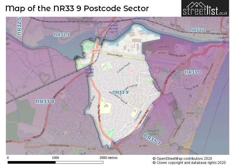
The NR33 9 Postcode shares a border with NR32 3 (LOWESTOFT, Oulton), NR33 0 (LOWESTOFT), NR33 7 (LOWESTOFT, Kessingland, Gisleham) and NR33 8 (Carlton Colville, LOWESTOFT, Gisleham).
The sector is within the post town of LOWESTOFT.
NR33 9 is a postcode sector within the NR3 postcode district which is within the NR Norwich postcode area.
The Royal Mail delivery office for the NR33 9 postal sector is the unknown.
The area of the NR33 9 postcode sector is 1.07 square miles which is 2.77 square kilometres or 684.55 square acres.

Map of the NR33 9 Postcode Sector
Explore the NR33 9 postcode sector by using our free interactive map.
| N | R | 3 | 3 | - | 9 | X | X |
| N | R | 3 | 3 | Space | 9 | Letter | Letter |
Official List of Streets
LOWESTOFT (112 Streets)
Unofficial Streets or Alternative Spellings
LOWESTOFT
BEVERLEY CLOSE BLACKHEATH ROAD BLOODMOOR ROAD CONRAD ROAD KIRKLEY RUN LAXFIELD WAY NOTLEY ROAD PLOVERS WAY PRIVATE ROAD WAVENEY DRIVE CAMOUSTIE DRIVE CASTLETON AVENUE COLVILLE WORKS ROAD DELL COURT FRESHWATER WAY LAKE VIEW TERRACE MAPLE ROAD NELSON WHARF ORCHARD GARDEN RICHARDSS CLOSE SALTWATER WAY THE BOULEVARD TOM CRISP WAYCarlton Colville
LONG ROAD LONGBROOK CLOSE ORCHARD CROFT SEDLESCOMBE ROAD THE RIDGEWAYSWeather Forecast for NR33 9
Press Button to Show Forecast for Lowestoft - South Of Claremont Pier (Beach)
| Time Period | Icon | Description | Temperature | Rain Probability | Wind |
|---|---|---|---|---|---|
| 21:00 to 00:00 | Cloudy | 8.0°C (feels like 5.0°C) | 7.00% | SSW 11 mph |
Press Button to Show Forecast for Lowestoft - South Of Claremont Pier (Beach)
| Time Period | Icon | Description | Temperature | Rain Probability | Wind |
|---|---|---|---|---|---|
| 00:00 to 03:00 | Clear night | 7.0°C (feels like 4.0°C) | 0.00% | SSW 11 mph | |
| 03:00 to 06:00 | Clear night | 6.0°C (feels like 3.0°C) | 0.00% | SSW 9 mph | |
| 06:00 to 09:00 | Sunny day | 8.0°C (feels like 5.0°C) | 0.00% | SSW 11 mph | |
| 09:00 to 12:00 | Partly cloudy (day) | 12.0°C (feels like 9.0°C) | 0.00% | S 18 mph | |
| 12:00 to 15:00 | Sunny day | 13.0°C (feels like 9.0°C) | 0.00% | S 20 mph | |
| 15:00 to 18:00 | Sunny day | 14.0°C (feels like 10.0°C) | 0.00% | S 18 mph | |
| 18:00 to 21:00 | Sunny day | 12.0°C (feels like 10.0°C) | 0.00% | S 13 mph | |
| 21:00 to 00:00 | Clear night | 10.0°C (feels like 8.0°C) | 0.00% | SSE 11 mph |
Press Button to Show Forecast for Lowestoft - South Of Claremont Pier (Beach)
| Time Period | Icon | Description | Temperature | Rain Probability | Wind |
|---|---|---|---|---|---|
| 00:00 to 03:00 | Clear night | 9.0°C (feels like 7.0°C) | 0.00% | SSE 9 mph | |
| 03:00 to 06:00 | Clear night | 9.0°C (feels like 7.0°C) | 0.00% | SE 9 mph | |
| 06:00 to 09:00 | Sunny day | 11.0°C (feels like 9.0°C) | 0.00% | SE 9 mph | |
| 09:00 to 12:00 | Cloudy | 14.0°C (feels like 12.0°C) | 5.00% | SE 11 mph | |
| 12:00 to 15:00 | Cloudy | 14.0°C (feels like 12.0°C) | 6.00% | SE 11 mph | |
| 15:00 to 18:00 | Cloudy | 15.0°C (feels like 13.0°C) | 6.00% | SSE 11 mph | |
| 18:00 to 21:00 | Cloudy | 13.0°C (feels like 12.0°C) | 9.00% | SE 9 mph | |
| 21:00 to 00:00 | Light rain | 12.0°C (feels like 11.0°C) | 51.00% | SE 7 mph |
Press Button to Show Forecast for Lowestoft - South Of Claremont Pier (Beach)
| Time Period | Icon | Description | Temperature | Rain Probability | Wind |
|---|---|---|---|---|---|
| 00:00 to 03:00 | Cloudy | 11.0°C (feels like 10.0°C) | 16.00% | SE 4 mph | |
| 03:00 to 06:00 | Cloudy | 10.0°C (feels like 9.0°C) | 17.00% | SE 4 mph | |
| 06:00 to 09:00 | Cloudy | 11.0°C (feels like 10.0°C) | 12.00% | ENE 4 mph | |
| 09:00 to 12:00 | Cloudy | 14.0°C (feels like 14.0°C) | 10.00% | E 4 mph | |
| 12:00 to 15:00 | Cloudy | 16.0°C (feels like 15.0°C) | 8.00% | NE 7 mph | |
| 15:00 to 18:00 | Cloudy | 15.0°C (feels like 13.0°C) | 6.00% | NNE 9 mph | |
| 18:00 to 21:00 | Cloudy | 12.0°C (feels like 10.0°C) | 7.00% | N 9 mph | |
| 21:00 to 00:00 | Cloudy | 11.0°C (feels like 9.0°C) | 10.00% | N 11 mph |
Press Button to Show Forecast for Lowestoft - South Of Claremont Pier (Beach)
| Time Period | Icon | Description | Temperature | Rain Probability | Wind |
|---|---|---|---|---|---|
| 00:00 to 03:00 | Cloudy | 11.0°C (feels like 8.0°C) | 11.00% | NNW 9 mph | |
| 03:00 to 06:00 | Partly cloudy (night) | 11.0°C (feels like 8.0°C) | 4.00% | NNW 11 mph | |
| 06:00 to 09:00 | Cloudy | 11.0°C (feels like 9.0°C) | 7.00% | NNW 9 mph | |
| 09:00 to 12:00 | Cloudy | 14.0°C (feels like 11.0°C) | 6.00% | NNW 11 mph | |
| 12:00 to 15:00 | Cloudy | 15.0°C (feels like 13.0°C) | 4.00% | NNW 13 mph | |
| 15:00 to 18:00 | Partly cloudy (day) | 16.0°C (feels like 14.0°C) | 2.00% | N 11 mph | |
| 18:00 to 21:00 | Partly cloudy (day) | 14.0°C (feels like 13.0°C) | 1.00% | N 9 mph | |
| 21:00 to 00:00 | Partly cloudy (night) | 11.0°C (feels like 10.0°C) | 2.00% | N 9 mph |
Schools and Places of Education Within the NR33 9 Postcode Sector
Dell Primary School
Academy sponsor led
Dell Road, Lowestoft, Suffolk, NR33 9NU
Head: Miss Adele Sinclair
Ofsted Rating: Good
Inspection: 2022-05-13 (716 days ago)
Website: Visit Dell Primary School Website
Phone: 01502565956
Number of Pupils: 362
Elm Tree Primary School
Academy sponsor led
Ranworth Avenue, Lowestoft, Suffolk, NR33 9HN
Head: Mrs Julia Halliday
Ofsted Rating: Good
Inspection: 2022-07-13 (655 days ago)
Website: Visit Elm Tree Primary School Website
Phone: 01502562930
Number of Pupils: 305
Westwood Primary School
Academy sponsor led
Westwood Avenue, Lowestoft, Suffolk, NR33 9RR
Head: Mrs Rae Aldous
Ofsted Rating: Good
Inspection: 2022-03-02 (788 days ago)
Website: Visit Westwood Primary School Website
Phone: 01502565673
Number of Pupils: 218
House Prices in the NR33 9 Postcode Sector
| Type of Property | 2018 Average | 2018 Sales | 2017 Average | 2017 Sales | 2016 Average | 2016 Sales | 2015 Average | 2015 Sales |
|---|---|---|---|---|---|---|---|---|
| Detached | £257,370 | 49 | £224,698 | 45 | £231,854 | 38 | £203,475 | 53 |
| Semi-Detached | £173,410 | 62 | £168,984 | 55 | £151,686 | 63 | £145,795 | 56 |
| Terraced | £146,385 | 31 | £142,015 | 29 | £121,084 | 30 | £119,151 | 31 |
| Flats | £101,333 | 3 | £96,333 | 3 | £92,667 | 3 | £74,415 | 3 |
Important Postcodes NR33 9 in the Postcode Sector
NR33 9DF is the postcode for Andaman Surgery, 303 Long Road
NR33 9HN is the postcode for Elm Tree Primary School, Ranworth Avenue
NR33 9HQ is the postcode for Elm Tree Primary School, Ranworth Avenue
NR33 9LU is the postcode for Doctors Surgery, 82 Victoria Road
NR33 9NU is the postcode for KITCHEN BLOCK, Dell Cp School, Dell Road, Main Block, Dell Primary School, Dell Road, SCHOOL ANNEXE, Dell Cp School, Dell Road, and Dell Cp School, Dell Road
NR33 9RR is the postcode for Westwood Primary School, Westwood Avenue, and WESTWOOD PRIMARY SCHOOL, WESTWOOD AVENUE, LOWESTOFT
| The NR33 9 Sector is within these Local Authorities |
|
|---|---|
| The NR33 9 Sector is within these Counties |
|
| The NR33 9 Sector is within these Water Company Areas |
|
Tourist Attractions within the NR33 9 Postcode Area
We found 1 visitor attractions within the NR3 postcode area
| Lowestoft Museum in Broad House |
|---|
| Museums & Art Galleries |
| Museum and / or Art Gallery |
| View Lowestoft Museum in Broad House on Google Maps |