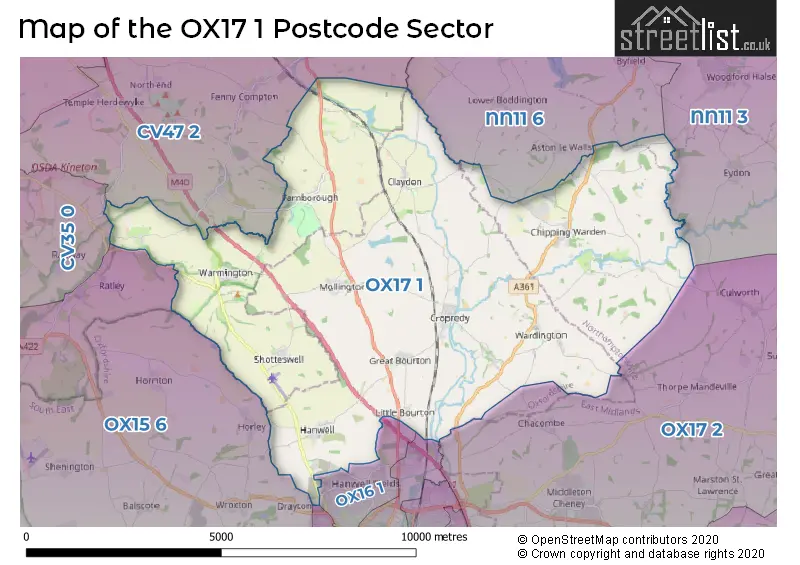
The OX17 1 postcode sector lies where the three counties of Warwickshire, Northamptonshire, and Oxfordshire meet.
Did you know? According to the 2021 Census, the OX17 1 postcode sector is home to a bustling 4,749 residents!
Given that each sector allows for 400 unique postcode combinations. Letters C, I, K, M, O and V are not allowed in the last two letters of a postcode. With 241 postcodes already in use, this leaves 159 units available.
The largest settlement in the OX17 1 postal code is Cropredy followed by Chipping Warden, and Mollington.
The OX17 1 Postcode shares a border with OX15 6 (Wroxton, Shenington, Shutford), OX16 0 (BANBURY), OX16 1 (BANBURY), OX16 2 (BANBURY), NN11 3 (Woodford Halse, Eydon, Badby), NN11 6 (Byfield, Staverton, Upper Boddington), OX17 2 (Middleton Cheney, Greatworth, Chacombe), CV35 0 (Kineton, Lighthorne, Gaydon) and CV47 2 (Bishops Itchington, Fenny Compton, Temple Herdewyke).
The sector is within the post town of BANBURY.
OX17 1 is a postcode sector within the OX1 postcode district which is within the OX Oxford postcode area.
The Royal Mail delivery office for the OX17 1 postal sector is the Oxford Delivery Office.
The area of the OX17 1 postcode sector is 32.53 square miles which is 84.26 square kilometres or 20,821.55 square acres.
The OX17 1 postcode sector is crossed by the M40 motorway.
Waterways within the OX17 1 postcode sector include the Oxford Canal, Cherwell.


Map of the OX17 1 Postcode Sector
Explore the OX17 1 postcode sector by using our free interactive map.
| O | X | 1 | 7 | - | 1 | X | X |
| O | X | 1 | 7 | Space | 1 | Letter | Letter |
Official List of Streets
Chipping Warden (10 Streets)
Claydon (11 Streets)
Little Bourton (6 Streets)
Warmington (10 Streets)
Cropredy (19 Streets)
Shotteswell (7 Streets)
Wardington (7 Streets)
Mollington (17 Streets)
Great Bourton (15 Streets)
Farnborough (8 Streets)
Williamscot (1 Streets)
BANBURY (4 Streets)
Arlescote (1 Streets)
Hanwell (5 Streets)
Schools and Places of Education Within the OX17 1 Postcode Sector
Chipping Warden Primary Academy
Academy converter
Byfield Road, Banbury, Oxfordshire, OX17 1LD
Head: Mrs Hazel Williams
Ofsted Rating: Good
Inspection: 2023-05-24 (368 days ago)
Website: Visit Chipping Warden Primary Academy Website
Phone: 01295660616
Number of Pupils: 80
House Prices in the OX17 1 Postcode Sector
| Type of Property | 2018 Average | 2018 Sales | 2017 Average | 2017 Sales | 2016 Average | 2016 Sales | 2015 Average | 2015 Sales |
|---|---|---|---|---|---|---|---|---|
| Detached | £436,300 | 25 | £467,303 | 38 | £518,270 | 35 | £478,516 | 30 |
| Semi-Detached | £312,917 | 12 | £311,054 | 21 | £347,395 | 19 | £315,008 | 24 |
| Terraced | £299,104 | 24 | £274,091 | 11 | £297,735 | 17 | £295,031 | 16 |
| Flats | £0 | 0 | £0 | 0 | £0 | 0 | £895,000 | 1 |
Important Postcodes OX17 1 in the Postcode Sector
OX17 1FB is the postcode for Cropredy Surgery, Claydon Road
OX17 1LD is the postcode for Chipping Warden Primary School, Byfield Road
OX17 1PU is the postcode for Cropredy C of E School, Station Road
| The OX17 1 Sector is within these Local Authorities |
|
|---|---|
| The OX17 1 Sector is within these Counties |
|
| The OX17 1 Sector is within these Water Company Areas |
|
Tourist Attractions within the OX17 1 Postcode Area
We found 1 visitor attractions within the OX1 postcode area
| Farnborough Hall |
|---|
| Historic Properties |
| Historic House / House and Garden / Palace |
| View Farnborough Hall on Google Maps |