The OX11 0 postcode sector stands on the Oxfordshire and Berkshire border.
Did you know? According to the 2021 Census, the OX11 0 postcode sector is home to a bustling 7,153 residents!
Given that each sector allows for 400 unique postcode combinations. Letters C, I, K, M, O and V are not allowed in the last two letters of a postcode. With 231 postcodes already in use, this leaves 169 units available.
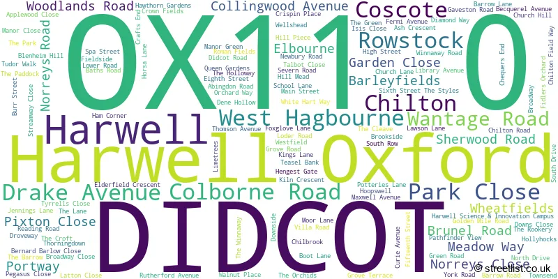
The largest settlement in the OX11 0 postal code is Harwell followed by Chilton, and DIDCOT.
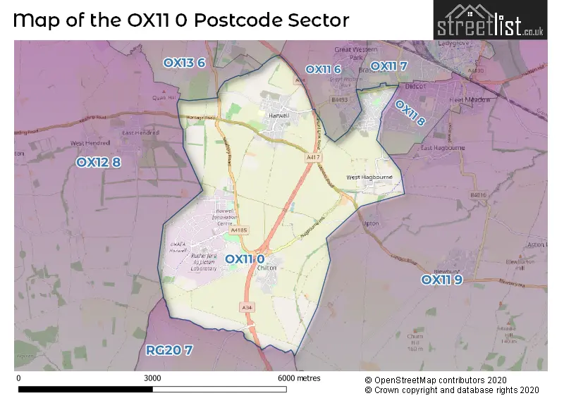
The OX11 0 Postcode shares a border with OX11 6 (DIDCOT, Harwell), OX13 6 (Steventon, Marcham, Wootton), OX11 8 (DIDCOT), OX12 8 (WANTAGE, East Hendred, Ardington), OX11 7 (DIDCOT), OX11 9 (DIDCOT, Blewbury, East Hagbourne), OX14 4 (Sutton Courtenay, Drayton, Milton) and RG20 7 (East Ilsley, Chaddleworth, Brightwalton).
The sector is within the post town of DIDCOT.
OX11 0 is a postcode sector within the OX11 postcode district which is within the OX Oxford postcode area.
The Royal Mail delivery office for the OX11 0 postal sector is the Didcot Delivery Office.
The area of the OX11 0 postcode sector is 8.52 square miles which is 22.07 square kilometres or 5,453.59 square acres.
The OX11 0 postcode sector is crossed by the A34 Major A road.

Map of the OX11 0 Postcode Sector
Explore the OX11 0 postcode sector by using our free interactive map.
| O | X | 1 | 1 | - | 0 | X | X |
| O | X | 1 | 1 | Space | 0 | Letter | Letter |
Official List of Streets
Harwell (58 Streets)
DIDCOT (18 Streets)
Chilton (36 Streets)
Harwell Oxford (12 Streets)
West Hagbourne (7 Streets)
Unofficial Streets or Alternative Spellings
DIDCOT
BUCKTHORN CRESCENT CHAMOMILE WAY DIAMOND DRIVE MANOR CRESCENT MARJORAM WAY OXFORD CRESCENT PARK ROAD REDWING END REED STREET SCOTS PINE WAY SLADE ROAD SORREL CRESCENT WAGTAIL HAVEN WINTERGREEN CLOSE YELLOWHAMMER PLACE ABINGDON TERRACE ASPEN WAY AVOCET CLOSE AVON ROAD BARGEWAY BECQUEREL AVENUE BUS TERMINUS BEECH LANE BIRCH CLOSE BLUEBELL LANE BOX TREE LANE BROOK LANE BURDOCK SPUR BUTTERCUP MEWS BUZZARD RISE CEDAR CLOSE CHILLBROOK CHILTON JUNCTION CLOVER FIELDS COLN ROAD COSCOTE COW LANE COWSLIP GATE CROWBERRY PLACE DALTON AVENUE DIDCOT, NEWBURY AND SOUTHAMPTON RAILWAY PATH DIDO ROAD DOWNS LANE DOWNS WAY DREWITTS CORNER DROVE WAY DYER STRAITS EIDER WAY ELDER CLOSE ELEVENTH STREET FALCON DRIVE FARADAY AVENUE FIRST STREET FOURTEENTH STREET FOURTH STREET FROME ROAD GOLDCREST GARDENS GUELDER ROSE HAGBOURNE HILL HARWELL LINK ROAD HILLSIDE HONEYSUCKLE WAY HUNGERFORD ROAD ICKNIELD WAY JUBILEE BRIDGE LARCH DRIVE LIDO ROAD LIME TREE FARM LINDEN GATE LINNET GROVE LYNCHWAY MEASHILL WAY NEWBURY ROAD CYCLE PATH NINETEENTH STREET NINTH STREET NUTHATCH END ORCHARD MEWS PARK LANE PERIMETER ROAD PILLWORT LANE PLANTATION ROAD PLUTO ROAD ROAD EIGHT ROAD EIGHTEEN ROAD ELEVEN ROAD FIFTEEN ROAD FIVE ROAD FOUR ROAD NINE ROAD NINETEEN ROAD ONE ROAD SEVEN ROAD SIX ROAD TEN ROAD THIRTEEN ROAD TWELVE ROAD TWO ROENTGEN AVENUE SEVENTEENTH STREET SNOWDROP DRIVE STILEWAY ROAD SUNDEW CLOSE SYCAMORE WAY TEAL CLOSE TENTH STREET THAMES ROAD THE DRIFTWAY THE GALLOPS THIRTEENTH STREET TWENTIETH STREET UPPER FARM ROAD VALE ROAD WELLSHEAD LANE WEST DRIVE WEST ILSLEY INTERCHANGE WHITE ROAD WILLOW ENDHarwell
HAZEL GARDENS HOLLY LANE THE POPLARSEast Hagbourne
MAIN ROADUpton
CHILTON ROAD READING ROADBlewbury
LONDON ROADWest Ilsley
BURY LANEWeather Forecast for OX11 0
Press Button to Show Forecast for Didcot
| Time Period | Icon | Description | Temperature | Rain Probability | Wind |
|---|---|---|---|---|---|
| 18:00 to 21:00 | Cloudy | 10.0°C (feels like 9.0°C) | 12.00% | E 7 mph | |
| 21:00 to 00:00 | Cloudy | 8.0°C (feels like 6.0°C) | 12.00% | ENE 7 mph |
Press Button to Show Forecast for Didcot
| Time Period | Icon | Description | Temperature | Rain Probability | Wind |
|---|---|---|---|---|---|
| 00:00 to 03:00 | Light rain | 7.0°C (feels like 4.0°C) | 46.00% | ENE 7 mph | |
| 03:00 to 06:00 | Light rain | 6.0°C (feels like 3.0°C) | 58.00% | NE 9 mph | |
| 06:00 to 09:00 | Light rain | 6.0°C (feels like 3.0°C) | 57.00% | NE 9 mph | |
| 09:00 to 12:00 | Light rain | 6.0°C (feels like 3.0°C) | 53.00% | NE 9 mph | |
| 12:00 to 15:00 | Overcast | 8.0°C (feels like 6.0°C) | 14.00% | NE 9 mph | |
| 15:00 to 18:00 | Cloudy | 10.0°C (feels like 8.0°C) | 11.00% | NE 9 mph | |
| 18:00 to 21:00 | Cloudy | 9.0°C (feels like 7.0°C) | 13.00% | NNE 11 mph | |
| 21:00 to 00:00 | Heavy rain | 8.0°C (feels like 5.0°C) | 82.00% | NNE 11 mph |
Press Button to Show Forecast for Didcot
| Time Period | Icon | Description | Temperature | Rain Probability | Wind |
|---|---|---|---|---|---|
| 00:00 to 03:00 | Heavy rain | 7.0°C (feels like 4.0°C) | 84.00% | NNE 11 mph | |
| 03:00 to 06:00 | Heavy rain | 7.0°C (feels like 3.0°C) | 83.00% | N 13 mph | |
| 06:00 to 09:00 | Heavy rain | 6.0°C (feels like 3.0°C) | 87.00% | N 11 mph | |
| 09:00 to 12:00 | Heavy rain | 7.0°C (feels like 4.0°C) | 82.00% | NW 11 mph | |
| 12:00 to 15:00 | Light rain | 9.0°C (feels like 6.0°C) | 56.00% | NW 11 mph | |
| 15:00 to 18:00 | Light rain | 10.0°C (feels like 8.0°C) | 42.00% | W 9 mph | |
| 18:00 to 21:00 | Partly cloudy (day) | 10.0°C (feels like 8.0°C) | 4.00% | WSW 7 mph | |
| 21:00 to 00:00 | Partly cloudy (night) | 7.0°C (feels like 5.0°C) | 4.00% | SW 7 mph |
Press Button to Show Forecast for Didcot
| Time Period | Icon | Description | Temperature | Rain Probability | Wind |
|---|---|---|---|---|---|
| 00:00 to 03:00 | Clear night | 5.0°C (feels like 3.0°C) | 1.00% | SW 7 mph | |
| 03:00 to 06:00 | Clear night | 4.0°C (feels like 2.0°C) | 1.00% | SSW 4 mph | |
| 06:00 to 09:00 | Sunny day | 5.0°C (feels like 3.0°C) | 1.00% | S 7 mph | |
| 09:00 to 12:00 | Partly cloudy (day) | 11.0°C (feels like 9.0°C) | 1.00% | S 11 mph | |
| 12:00 to 15:00 | Partly cloudy (day) | 13.0°C (feels like 10.0°C) | 3.00% | S 13 mph | |
| 15:00 to 18:00 | Partly cloudy (day) | 14.0°C (feels like 11.0°C) | 2.00% | S 13 mph | |
| 18:00 to 21:00 | Sunny day | 12.0°C (feels like 10.0°C) | 2.00% | S 9 mph | |
| 21:00 to 00:00 | Clear night | 8.0°C (feels like 6.0°C) | 3.00% | SSE 7 mph |
Press Button to Show Forecast for Didcot
| Time Period | Icon | Description | Temperature | Rain Probability | Wind |
|---|---|---|---|---|---|
| 00:00 to 03:00 | Clear night | 7.0°C (feels like 5.0°C) | 3.00% | SE 7 mph | |
| 03:00 to 06:00 | Partly cloudy (night) | 7.0°C (feels like 5.0°C) | 3.00% | SE 9 mph | |
| 06:00 to 09:00 | Sunny day | 8.0°C (feels like 6.0°C) | 4.00% | SE 9 mph | |
| 09:00 to 12:00 | Partly cloudy (day) | 13.0°C (feels like 11.0°C) | 6.00% | SE 11 mph | |
| 12:00 to 15:00 | Partly cloudy (day) | 15.0°C (feels like 13.0°C) | 9.00% | SE 13 mph | |
| 15:00 to 18:00 | Cloudy | 16.0°C (feels like 14.0°C) | 8.00% | SSE 11 mph | |
| 18:00 to 21:00 | Partly cloudy (day) | 14.0°C (feels like 13.0°C) | 5.00% | SE 7 mph | |
| 21:00 to 00:00 | Partly cloudy (night) | 11.0°C (feels like 10.0°C) | 5.00% | ESE 7 mph |
Schools and Places of Education Within the OX11 0 Postcode Sector
Chilton County Primary School
Community school
Downside, Didcot, Oxfordshire, OX11 0PQ
Head: Miss Rebecca Vousden
Ofsted Rating: Good
Inspection: 2019-02-14 (1898 days ago)
Website: Visit Chilton County Primary School Website
Phone: 01235834263
Number of Pupils: 312
Harwell Primary School
Community school
The Styles, Didcot, , OX11 0HX
Head: Mr Bryn Gibson
Ofsted Rating: Good
Inspection: 2022-09-14 (590 days ago)
Website: Visit Harwell Primary School Website
Phone: 01235835337
Number of Pupils: 206
House Prices in the OX11 0 Postcode Sector
| Type of Property | 2018 Average | 2018 Sales | 2017 Average | 2017 Sales | 2016 Average | 2016 Sales | 2015 Average | 2015 Sales |
|---|---|---|---|---|---|---|---|---|
| Detached | £522,323 | 83 | £523,493 | 58 | £512,976 | 48 | £444,918 | 71 |
| Semi-Detached | £321,734 | 40 | £328,451 | 46 | £314,388 | 45 | £293,158 | 44 |
| Terraced | £270,477 | 22 | £309,780 | 25 | £262,761 | 19 | £256,411 | 27 |
| Flats | £219,188 | 8 | £205,400 | 5 | £0 | 0 | £213,000 | 3 |
Important Postcodes OX11 0 in the Postcode Sector
OX11 0AF is the postcode for Ridgeway Day Hospital, 99 Wantage Road
OX11 0AG is the postcode for Oxfordshire PCT, Didcot Hospital, DIDCOT HOSPITAL, WANTAGE ROAD, DIDCOT, and Didcot Hospital, Wantage Road
OX11 0BB is the postcode for Woodlands Medical Centre, Woodlands Road
OX11 0HX is the postcode for Harwell Cp School, The Styles, Harwell, and Harwell Cp School, The Styles
OX11 0LH is the postcode for Harwell Cp School, Orchard Way
OX11 0PQ is the postcode for Chilton Cp School, Downside
OX11 0QX is the postcode for BUILDING R18, STFC, Rutherford Appleton Laboratory Harwell Science & Innovation Campus, and BUILDING R97, STFC, Rutherford Appleton Laboratory Harwell Science & Innovation Campus
OX11 0RH is the postcode for N D A, Curie Avenue
OX11 0RQ is the postcode for UKHSA, Chilton, Harwell Campus, UKHSA, F Block, Chilton, and Public Health England, Chilton
| The OX11 0 Sector is within these Local Authorities |
|
|---|---|
| The OX11 0 Sector is within these Counties |
|
| The OX11 0 Sector is within these Water Company Areas |
|