The OX12 8 postcode sector stands on the Berkshire and Oxfordshire border.
Did you know? According to the 2021 Census, the OX12 8 postcode sector is home to a bustling 6,126 residents!
Given that each sector allows for 400 unique postcode combinations. Letters C, I, K, M, O and V are not allowed in the last two letters of a postcode. With 229 postcodes already in use, this leaves 171 units available.
The largest settlement in the OX12 8 postal code is WANTAGE followed by East Hendred, and Ardington.
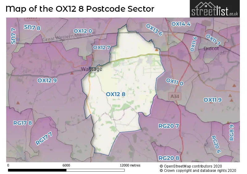
The OX12 8 Postcode shares a border with OX13 6 (Steventon, Marcham, Wootton), OX11 0 (Harwell, Chilton, DIDCOT), OX12 7 (WANTAGE, Grove, Charlton), OX12 9 (WANTAGE, East Challow, Letcombe Regis), OX12 0 (Grove, East Hanney, West Hanney) and RG20 7 (East Ilsley, Chaddleworth, Brightwalton).
The sector is within the post town of WANTAGE.
OX12 8 is a postcode sector within the OX12 postcode district which is within the OX Oxford postcode area.
The Royal Mail delivery office for the OX12 8 postal sector is the Wantage Delivery Office.
The area of the OX12 8 postcode sector is 25.47 square miles which is 65.97 square kilometres or 16,302.09 square acres.
Waterways within the OX12 8 postcode sector include the Ginge Brook, Wilts & Berks Canal.

Map of the OX12 8 Postcode Sector
Explore the OX12 8 postcode sector by using our free interactive map.
| O | X | 1 | 2 | - | 8 | X | X |
| O | X | 1 | 2 | Space | 8 | Letter | Letter |
Official List of Streets
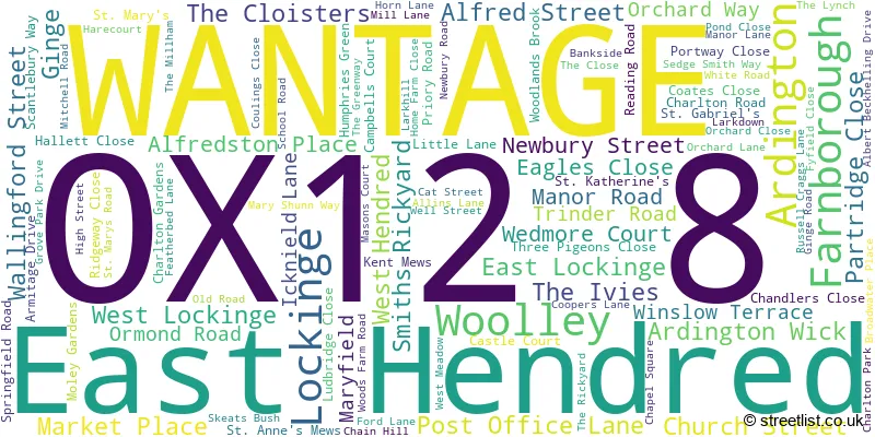
WANTAGE (53 Streets)
East Hendred (25 Streets)
West Hendred (7 Streets)
Ardington (7 Streets)
Lockinge (1 Streets)
Woolley (1 Streets)
Farnborough (2 Streets)
Unofficial Streets or Alternative Spellings
Rowstock
WANTAGE ROADWANTAGE
GROVE STREET MILL STREET PALMERS PORTWAY WILLOW LANECharlton
CHARLTON VILLAGE ROADGrove Park
GROVE PARK DRIVEGreat Shefford
WANTAGE ROADWeather Forecast for OX12 8
Press Button to Show Forecast for West Ginge
| Time Period | Icon | Description | Temperature | Rain Probability | Wind |
|---|---|---|---|---|---|
| 09:00 to 12:00 | Sunny day | 14.0°C (feels like 13.0°C) | 1.00% | SE 4 mph | |
| 12:00 to 15:00 | Cloudy | 16.0°C (feels like 15.0°C) | 5.00% | SE 7 mph | |
| 15:00 to 18:00 | Cloudy | 16.0°C (feels like 14.0°C) | 5.00% | S 9 mph | |
| 18:00 to 21:00 | Cloudy | 13.0°C (feels like 12.0°C) | 6.00% | S 7 mph | |
| 21:00 to 00:00 | Cloudy | 11.0°C (feels like 11.0°C) | 14.00% | S 2 mph |
Press Button to Show Forecast for West Ginge
| Time Period | Icon | Description | Temperature | Rain Probability | Wind |
|---|---|---|---|---|---|
| 00:00 to 03:00 | Cloudy | 10.0°C (feels like 9.0°C) | 14.00% | SSE 2 mph | |
| 03:00 to 06:00 | Cloudy | 9.0°C (feels like 9.0°C) | 18.00% | NE 2 mph | |
| 06:00 to 09:00 | Cloudy | 10.0°C (feels like 10.0°C) | 11.00% | NNE 4 mph | |
| 09:00 to 12:00 | Cloudy | 13.0°C (feels like 12.0°C) | 10.00% | N 4 mph | |
| 12:00 to 15:00 | Cloudy | 15.0°C (feels like 13.0°C) | 12.00% | NE 9 mph | |
| 15:00 to 18:00 | Cloudy | 15.0°C (feels like 14.0°C) | 12.00% | NE 7 mph | |
| 18:00 to 21:00 | Light rain shower (day) | 14.0°C (feels like 13.0°C) | 28.00% | N 7 mph | |
| 21:00 to 00:00 | Cloudy | 12.0°C (feels like 11.0°C) | 7.00% | NW 4 mph |
Press Button to Show Forecast for West Ginge
| Time Period | Icon | Description | Temperature | Rain Probability | Wind |
|---|---|---|---|---|---|
| 00:00 to 03:00 | Partly cloudy (night) | 10.0°C (feels like 9.0°C) | 4.00% | NW 4 mph | |
| 03:00 to 06:00 | Partly cloudy (night) | 9.0°C (feels like 8.0°C) | 3.00% | NW 7 mph | |
| 06:00 to 09:00 | Cloudy | 10.0°C (feels like 8.0°C) | 6.00% | NW 7 mph | |
| 09:00 to 12:00 | Partly cloudy (day) | 13.0°C (feels like 12.0°C) | 2.00% | N 7 mph | |
| 12:00 to 15:00 | Partly cloudy (day) | 17.0°C (feels like 16.0°C) | 3.00% | N 7 mph | |
| 15:00 to 18:00 | Partly cloudy (day) | 18.0°C (feels like 17.0°C) | 3.00% | NNW 7 mph | |
| 18:00 to 21:00 | Partly cloudy (day) | 17.0°C (feels like 16.0°C) | 3.00% | N 7 mph | |
| 21:00 to 00:00 | Clear night | 12.0°C (feels like 12.0°C) | 0.00% | N 4 mph |
Press Button to Show Forecast for West Ginge
| Time Period | Icon | Description | Temperature | Rain Probability | Wind |
|---|---|---|---|---|---|
| 00:00 to 03:00 | Partly cloudy (night) | 10.0°C (feels like 9.0°C) | 1.00% | NNE 4 mph | |
| 03:00 to 06:00 | Partly cloudy (night) | 8.0°C (feels like 7.0°C) | 1.00% | NNE 4 mph | |
| 06:00 to 09:00 | Cloudy | 9.0°C (feels like 9.0°C) | 5.00% | NE 4 mph | |
| 09:00 to 12:00 | Cloudy | 13.0°C (feels like 13.0°C) | 4.00% | NE 4 mph | |
| 12:00 to 15:00 | Cloudy | 17.0°C (feels like 17.0°C) | 4.00% | NE 4 mph | |
| 15:00 to 18:00 | Cloudy | 18.0°C (feels like 18.0°C) | 4.00% | NE 4 mph | |
| 18:00 to 21:00 | Cloudy | 18.0°C (feels like 17.0°C) | 4.00% | NE 4 mph | |
| 21:00 to 00:00 | Cloudy | 13.0°C (feels like 12.0°C) | 3.00% | NE 4 mph |
Schools and Places of Education Within the OX12 8 Postcode Sector
Huckleberry Therapeutic School
Other independent special school
Manor Road, , , OX12 8NE
Head: Mrs Louisa Skinner
Ofsted Rating: Inadequate
Inspection: 2022-06-09 (696 days ago)
Website: Visit Huckleberry Therapeutic School Website
Phone: 01235639511
Number of Pupils: 8
St Amand's Catholic Primary School
Voluntary aided school
St Mary's Road, Wantage, Oxfordshire, OX12 8LF
Head: Mrs Helen Ellery
Ofsted Rating: Good
Inspection: 2019-09-25 (1684 days ago)
Website: Visit St Amand's Catholic Primary School Website
Phone: 01235833342
Number of Pupils: 115
The Hendreds Church of England School
Academy converter
Ford Lane, Wantage, Oxfordshire, OX12 8JX
Head: Mrs Lisa Rees
Ofsted Rating: Good
Inspection: 2023-11-22 (165 days ago)
Website: Visit The Hendreds Church of England School Website
Phone: 01235833379
Number of Pupils: 139
Wantage Church of England Primary School
Academy converter
Newbury Street, Wantage, Oxfordshire, OX12 8DJ
Head: Mr Andrew Browne
Ofsted Rating: Good
Inspection: 2019-07-02 (1769 days ago)
Website: Visit Wantage Church of England Primary School Website
Phone: 01235762396
Number of Pupils: 431
House Prices in the OX12 8 Postcode Sector
| Type of Property | 2018 Average | 2018 Sales | 2017 Average | 2017 Sales | 2016 Average | 2016 Sales | 2015 Average | 2015 Sales |
|---|---|---|---|---|---|---|---|---|
| Detached | £580,869 | 26 | £534,947 | 35 | £499,679 | 33 | £513,941 | 27 |
| Semi-Detached | £348,003 | 29 | £361,440 | 21 | £370,188 | 25 | £344,363 | 28 |
| Terraced | £309,274 | 21 | £286,960 | 25 | £288,579 | 24 | £296,444 | 27 |
| Flats | £229,958 | 36 | £197,929 | 60 | £149,467 | 21 | £148,532 | 25 |
Important Postcodes OX12 8 in the Postcode Sector
OX12 8DJ is the postcode for Wantage C of E Primary School, Old School, Newbury Street
OX12 8ET is the postcode for King Alfreds Academy East, Springfield Road, N BLOCK - MAIN BUILDING, King Alfreds Academy East, Springfield Road, and CREATIVE ARTS & LSB, King Alfreds Academy East, Springfield Road
OX12 8JX is the postcode for The Hendreds Primary School, Ford Lane
OX12 8LF is the postcode for St. Amands RC Primary School, St. Marys Road, and St. Amands RC Primary School, St. Marys Road, East Hendred
| The OX12 8 Sector is within these Local Authorities |
|
|---|---|
| The OX12 8 Sector is within these Counties |
|
| The OX12 8 Sector is within these Water Company Areas |
|