The OX18 1 postcode sector is within the county of Oxfordshire.
Did you know? According to the 2021 Census, the OX18 1 postcode sector is home to a bustling 8,028 residents!
Given that each sector allows for 400 unique postcode combinations. Letters C, I, K, M, O and V are not allowed in the last two letters of a postcode. With 202 postcodes already in use, this leaves 198 units available.
The largest settlements in the OX18 1 postal code are CARTERTON and Brize Norton.
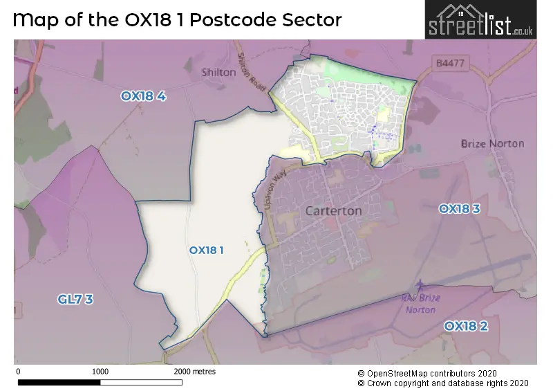
The OX18 1 Postcode shares a border with OX18 2 (BAMPTON, Aston, Clanfield), OX18 3 (CARTERTON, Brize Norton), OX18 4 (BURFORD, Fulbrook, Shilton) and GL7 3 (LECHLADE, Filkins, Eastleach).
The sector is within the post town of CARTERTON.
OX18 1 is a postcode sector within the OX18 postcode district which is within the OX Oxford postcode area.
The Royal Mail delivery office for the OX18 1 postal sector is the Carterton Delivery Office.
The area of the OX18 1 postcode sector is 1.89 square miles which is 4.89 square kilometres or 1,208.73 square acres.

Map of the OX18 1 Postcode Sector
Explore the OX18 1 postcode sector by using our free interactive map.
| O | X | 1 | 8 | - | 1 | X | X |
| O | X | 1 | 8 | Space | 1 | Letter | Letter |
Official List of Streets
CARTERTON (117 Streets)
Brize Norton (21 Streets)
Unofficial Streets or Alternative Spellings
CARTERTON
STANMORE CRESCENT CARTERTON LEISURE CENTRE COLOMBINE ROAD DOVE COURT FP 340/5/10 HEALD COURT KILKENNY LANE COUNTRY PARK NORTHWOOD CRESCENT OAKS MEAD ODIHAM CLOSE PITREAVIE AVENUE PRICE WAY RAYNHAM CLOSE SHILL BRIDGE SWINBROOK ROAD ALLOTMENTS TANGMERE AVENUE TRINDER PLACE UPWOOD DRIVE YATESBURY ROADBrize Norton
BURFORD ROAD KILKENNY LANE MONAHAN WAY NORTON WAYBURFORD,
SHILTON ROADWeather Forecast for OX18 1
Press Button to Show Forecast for Brize Norton
| Time Period | Icon | Description | Temperature | Rain Probability | Wind |
|---|---|---|---|---|---|
| 03:00 to 06:00 | Light rain | 6.0°C (feels like 3.0°C) | 77.00% | ENE 7 mph | |
| 06:00 to 09:00 | Light rain | 5.0°C (feels like 2.0°C) | 51.00% | NE 7 mph | |
| 09:00 to 12:00 | Heavy rain | 6.0°C (feels like 3.0°C) | 78.00% | NE 9 mph | |
| 12:00 to 15:00 | Light rain | 9.0°C (feels like 6.0°C) | 53.00% | ENE 9 mph | |
| 15:00 to 18:00 | Overcast | 10.0°C (feels like 8.0°C) | 14.00% | NE 11 mph | |
| 18:00 to 21:00 | Cloudy | 10.0°C (feels like 7.0°C) | 16.00% | NE 11 mph | |
| 21:00 to 00:00 | Heavy rain | 8.0°C (feels like 5.0°C) | 76.00% | NNE 9 mph |
Press Button to Show Forecast for Brize Norton
| Time Period | Icon | Description | Temperature | Rain Probability | Wind |
|---|---|---|---|---|---|
| 00:00 to 03:00 | Heavy rain | 7.0°C (feels like 4.0°C) | 85.00% | NNE 9 mph | |
| 03:00 to 06:00 | Heavy rain | 7.0°C (feels like 3.0°C) | 86.00% | N 9 mph | |
| 06:00 to 09:00 | Heavy rain | 6.0°C (feels like 2.0°C) | 92.00% | N 9 mph | |
| 09:00 to 12:00 | Heavy rain | 7.0°C (feels like 3.0°C) | 88.00% | NNW 9 mph | |
| 12:00 to 15:00 | Light rain | 9.0°C (feels like 6.0°C) | 47.00% | NW 11 mph | |
| 15:00 to 18:00 | Cloudy | 11.0°C (feels like 9.0°C) | 12.00% | WNW 9 mph | |
| 18:00 to 21:00 | Cloudy | 11.0°C (feels like 9.0°C) | 6.00% | W 7 mph | |
| 21:00 to 00:00 | Partly cloudy (night) | 8.0°C (feels like 6.0°C) | 2.00% | SW 4 mph |
Press Button to Show Forecast for Brize Norton
| Time Period | Icon | Description | Temperature | Rain Probability | Wind |
|---|---|---|---|---|---|
| 00:00 to 03:00 | Clear night | 5.0°C (feels like 3.0°C) | 1.00% | SW 4 mph | |
| 03:00 to 06:00 | Clear night | 4.0°C (feels like 2.0°C) | 1.00% | SSW 2 mph | |
| 06:00 to 09:00 | Sunny day | 5.0°C (feels like 3.0°C) | 1.00% | S 4 mph | |
| 09:00 to 12:00 | Partly cloudy (day) | 11.0°C (feels like 9.0°C) | 1.00% | S 9 mph | |
| 12:00 to 15:00 | Cloudy | 14.0°C (feels like 11.0°C) | 6.00% | S 11 mph | |
| 15:00 to 18:00 | Partly cloudy (day) | 14.0°C (feels like 11.0°C) | 2.00% | S 11 mph | |
| 18:00 to 21:00 | Sunny day | 13.0°C (feels like 11.0°C) | 2.00% | S 9 mph | |
| 21:00 to 00:00 | Clear night | 9.0°C (feels like 7.0°C) | 2.00% | SSE 7 mph |
Press Button to Show Forecast for Brize Norton
| Time Period | Icon | Description | Temperature | Rain Probability | Wind |
|---|---|---|---|---|---|
| 00:00 to 03:00 | Clear night | 8.0°C (feels like 5.0°C) | 2.00% | SE 7 mph | |
| 03:00 to 06:00 | Clear night | 7.0°C (feels like 5.0°C) | 2.00% | ESE 4 mph | |
| 06:00 to 09:00 | Partly cloudy (day) | 8.0°C (feels like 6.0°C) | 4.00% | ESE 7 mph | |
| 09:00 to 12:00 | Sunny day | 13.0°C (feels like 11.0°C) | 5.00% | SE 9 mph | |
| 12:00 to 15:00 | Partly cloudy (day) | 16.0°C (feels like 13.0°C) | 8.00% | SE 11 mph | |
| 15:00 to 18:00 | Cloudy | 16.0°C (feels like 14.0°C) | 9.00% | SE 11 mph | |
| 18:00 to 21:00 | Partly cloudy (day) | 15.0°C (feels like 13.0°C) | 5.00% | SE 7 mph | |
| 21:00 to 00:00 | Cloudy | 11.0°C (feels like 10.0°C) | 7.00% | SE 4 mph |
Schools and Places of Education Within the OX18 1 Postcode Sector
Carterton Community College
Community school
Upavon Way, Carterton, Oxfordshire, OX18 1BU
Head: Mr Chris Hart
Ofsted Rating: Good
Inspection: 2022-03-03 (786 days ago)
Website: Visit Carterton Community College Website
Phone: 01993841611
Number of Pupils: 639
St John the Evangelist CofE VA Primary School
Voluntary aided school
Bluebell Way, Carterton, Oxfordshire, OX18 1JF
Head: Mrs Marie Wargent
Ofsted Rating: Outstanding
Inspection: 2020-01-29 (1550 days ago)
Website: Visit St John the Evangelist CofE VA Primary School Website
Phone: 01993843124
Number of Pupils: 455
House Prices in the OX18 1 Postcode Sector
| Type of Property | 2018 Average | 2018 Sales | 2017 Average | 2017 Sales | 2016 Average | 2016 Sales | 2015 Average | 2015 Sales |
|---|---|---|---|---|---|---|---|---|
| Detached | £422,228 | 45 | £406,645 | 63 | £379,320 | 41 | £348,055 | 41 |
| Semi-Detached | £276,461 | 65 | £287,681 | 55 | £276,079 | 56 | £249,833 | 44 |
| Terraced | £261,026 | 38 | £250,819 | 47 | £236,316 | 82 | £231,827 | 67 |
| Flats | £161,352 | 27 | £175,594 | 28 | £174,155 | 42 | £157,584 | 52 |
Important Postcodes OX18 1 in the Postcode Sector
OX18 1AA is the postcode for Carterton Leisure Centre, Broadshires Way, and CARTERTON LEISURE CENTRE, BROADSHIRES WAY, CARTERTON
OX18 1BU is the postcode for Block D, Carterton Community College, Upavon Way, B BLOCK, Oxfordshire County Council, Carterton Community College, Upavon Way, MATHS AND IT BLOCK, Oxfordshire County Council, Carterton Community College, Upavon Way, A BLOCK, Oxfordshire County Council, Carterton Community College, Upavon Way, and C BLOCK, Oxfordshire County Council, Carterton Community College, Upavon Way
OX18 1JA is the postcode for The Broadshires Health Centre, Broadshires Way
OX18 1JF is the postcode for St. John the Evangelist C of E Primary School, Bluebell Way
| The OX18 1 Sector is within these Local Authorities |
|
|---|---|
| The OX18 1 Sector is within these Counties |
|
| The OX18 1 Sector is within these Water Company Areas |
|