The PA14 postcode district is a postal district located in the PA Paisley postcode area with a population of 16,503 residents according to the 2011 Scotland Census.
The area of the PA14 postcode district is 7.82 square miles which is 20.24 square kilometres or 5,001.71 acres.
Currently, the PA14 district has about 408 postcode units spread across 2 geographic postcode sectors.
Given that each sector allows for 400 unique postcode combinations, the district has a capacity of 800 postcodes. With 408 postcodes already in use, this leaves 392 units available.
The largest settlements in the PA14 postal code are PORT GLASGOW and Langbank.
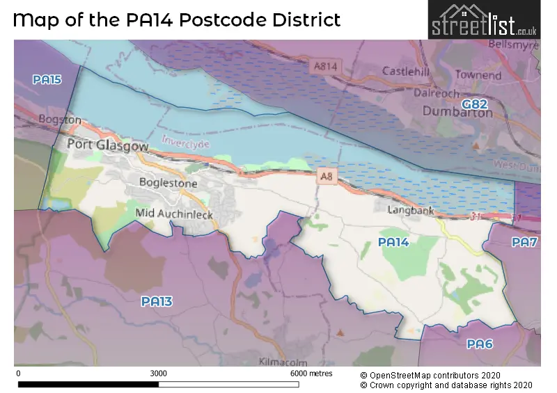
The postcode area has a boundary with Firth of Clyde.
The PA14 Postcode shares a border with PA15 (GREENOCK), PA13 (KILMACOLM), PA7 (BISHOPTON, Erskine Hospital) and PA6 (Houston, Crosslee).
The primary settlement in the PA14 postcode district is Port Glasgow, located in the county of Renfrewshire, Scotland. Additionally, Langbank is another significant settlement in the district. The most significant post town in the district is Port Glasgow.
For the district PA14, we have data on 2 postcode sectors. Here's a breakdown: The sector PA14 5, covers Port Glasgow in Renfrewshire. The sector PA14 6, covers Port Glasgow and Langbank in Renfrewshire.

Map of the PA14 Postcode District
Explore the PA14 postcode district by using our free interactive map.
When it comes to local government, postal geography often disregards political borders. However, for a breakdown in the PA14 District: the district mostly encompasses the Inverclyde (377 postcodes), and finally, the Renfrewshire area (38 postcodes).
Weather Forecast for PA14
Press Button to Show Forecast for Langbank
| Time Period | Icon | Description | Temperature | Rain Probability | Wind |
|---|---|---|---|---|---|
| 00:00 to 03:00 | Clear night | 5.0°C (feels like 4.0°C) | 0.00% | E 2 mph | |
| 03:00 to 06:00 | Partly cloudy (night) | 3.0°C (feels like 2.0°C) | 0.00% | E 2 mph | |
| 06:00 to 09:00 | Sunny day | 4.0°C (feels like 3.0°C) | 0.00% | ESE 2 mph | |
| 09:00 to 12:00 | Partly cloudy (day) | 7.0°C (feels like 6.0°C) | 1.00% | ESE 4 mph | |
| 12:00 to 15:00 | Cloudy | 9.0°C (feels like 9.0°C) | 11.00% | SSE 4 mph | |
| 15:00 to 18:00 | Light rain | 10.0°C (feels like 8.0°C) | 47.00% | WNW 7 mph | |
| 18:00 to 21:00 | Cloudy | 9.0°C (feels like 8.0°C) | 53.00% | S 4 mph | |
| 21:00 to 00:00 | Partly cloudy (night) | 7.0°C (feels like 6.0°C) | 1.00% | ENE 4 mph |
Press Button to Show Forecast for Langbank
| Time Period | Icon | Description | Temperature | Rain Probability | Wind |
|---|---|---|---|---|---|
| 00:00 to 03:00 | Clear night | 6.0°C (feels like 4.0°C) | 1.00% | NE 7 mph | |
| 03:00 to 06:00 | Partly cloudy (night) | 4.0°C (feels like 2.0°C) | 0.00% | NE 7 mph | |
| 06:00 to 09:00 | Sunny day | 5.0°C (feels like 2.0°C) | 1.00% | NE 7 mph | |
| 09:00 to 12:00 | Partly cloudy (day) | 8.0°C (feels like 6.0°C) | 1.00% | NE 7 mph | |
| 12:00 to 15:00 | Cloudy | 10.0°C (feels like 10.0°C) | 5.00% | WNW 4 mph | |
| 15:00 to 18:00 | Partly cloudy (day) | 11.0°C (feels like 9.0°C) | 3.00% | W 9 mph | |
| 18:00 to 21:00 | Sunny day | 10.0°C (feels like 8.0°C) | 2.00% | W 11 mph | |
| 21:00 to 00:00 | Clear night | 6.0°C (feels like 4.0°C) | 4.00% | WSW 7 mph |
Press Button to Show Forecast for Langbank
| Time Period | Icon | Description | Temperature | Rain Probability | Wind |
|---|---|---|---|---|---|
| 00:00 to 03:00 | Partly cloudy (night) | 5.0°C (feels like 4.0°C) | 5.00% | S 4 mph | |
| 03:00 to 06:00 | Cloudy | 6.0°C (feels like 4.0°C) | 10.00% | SSE 7 mph | |
| 06:00 to 09:00 | Cloudy | 7.0°C (feels like 5.0°C) | 11.00% | SSE 9 mph | |
| 09:00 to 12:00 | Light rain shower (day) | 10.0°C (feels like 8.0°C) | 35.00% | S 11 mph | |
| 12:00 to 15:00 | Light rain shower (day) | 11.0°C (feels like 8.0°C) | 50.00% | S 13 mph | |
| 15:00 to 18:00 | Light rain shower (day) | 12.0°C (feels like 9.0°C) | 35.00% | S 16 mph | |
| 18:00 to 21:00 | Light rain | 11.0°C (feels like 9.0°C) | 44.00% | SSE 13 mph | |
| 21:00 to 00:00 | Cloudy | 10.0°C (feels like 8.0°C) | 14.00% | SE 11 mph |
Press Button to Show Forecast for Langbank
| Time Period | Icon | Description | Temperature | Rain Probability | Wind |
|---|---|---|---|---|---|
| 00:00 to 03:00 | Partly cloudy (night) | 9.0°C (feels like 7.0°C) | 8.00% | SE 9 mph | |
| 03:00 to 06:00 | Cloudy | 9.0°C (feels like 6.0°C) | 12.00% | ESE 9 mph | |
| 06:00 to 09:00 | Cloudy | 9.0°C (feels like 7.0°C) | 10.00% | ESE 9 mph | |
| 09:00 to 12:00 | Partly cloudy (day) | 11.0°C (feels like 9.0°C) | 7.00% | ESE 11 mph | |
| 12:00 to 15:00 | Cloudy | 14.0°C (feels like 12.0°C) | 10.00% | ESE 13 mph | |
| 15:00 to 18:00 | Partly cloudy (day) | 14.0°C (feels like 12.0°C) | 6.00% | ESE 11 mph | |
| 18:00 to 21:00 | Partly cloudy (day) | 13.0°C (feels like 11.0°C) | 6.00% | SSW 11 mph | |
| 21:00 to 00:00 | Cloudy | 11.0°C (feels like 8.0°C) | 15.00% | E 11 mph |
Where is the PA14 Postcode District?
The postcode district PA14 is located in the town of Port Glasgow. It is situated near several towns including Stirling to the West, Kilmacolm to the Southwest, Bridge of Weir to the South, Bishopton to the East, Glenrothes to the North, and Edinburgh to the Northwest. The district is approximately 356.4 miles away from the center of London.
The district is within the post town of PORT GLASGOW.
The sector has postcodes within the nation of Scotland.
The PA14 Postcode District is in the Inverclyde, East Renfrewshire and Renfrewshire region of West Central Scotland within the Scotland.
| Postcode Sector | Delivery Office |
|---|---|
| PA14 5 | Greenock Delivery Office |
| PA14 6 | Greenock Delivery Office |
| P | A | 1 | 4 | - | X | X | X |
| P | A | 1 | 4 | Space | Numeric | Letter | Letter |
Current Monthly Rental Prices
| # Bedrooms | Min Price | Max Price | Avg Price |
|---|---|---|---|
| 1 | £420 | £420 | £420 |
| 2 | £495 | £800 | £648 |
Current House Prices
| # Bedrooms | Min Price | Max Price | Avg Price |
|---|---|---|---|
| £95,000 | £95,000 | £95,000 | |
| 1 | £6,000 | £50,000 | £27,500 |
| 2 | £35,000 | £115,500 | £71,625 |
| 3 | £94,000 | £310,000 | £231,800 |
| 4 | £230,000 | £400,000 | £315,000 |
| 5 | £345,000 | £398,000 | £371,500 |
Estate Agents who Operate in the PA14 District
| Logo | Name | Brand Name | Address | Contact Number | Total Properties |
|---|---|---|---|---|---|
 | covering Paisley | Purplebricks | Suite 7 First Floor Cranmore Drive Shirley Solihull B90 4RZ | 020 3909 9868 | 3 |
 | Port Glasgow | Brian Harkins | 18 John Wood Street, Port Glasgow, PA14 5HU | 01475 603714 | 3 |
 | Glasgow | Future Property Auctions | 241 Kilmarnock Road Glasgow G41 3JF | 0141 632 6599 | 3 |
 | Gourock | McArthur Scott | 11 John Street, Gourock, PA19 1PR | 01475 603703 | 2 |
 | Greenock | Slater Hogg & Howison | 55 West Blackhall Street Greenock PA15 1UT | 01475 603717 | 2 |