The PA45 postcode district is a postal district located in the PA Paisley postcode area with a population of 122 residents according to the 2011 Scotland Census.
The area of the PA45 postcode district is 15.20 square miles which is 39.37 square kilometres or 9,727.97 acres.
Currently, the PA45 district has about 7 postcode units spread across 0 geographic postcode sectors.
Given that each sector allows for 400 unique postcode combinations, the district has a capacity of 0 postcodes. With 7 postcodes already in use, this leaves -7 units available.
The PA45 postal code covers the settlement of Ballygrant.
The postcode area has a boundary with The North Atlantic Ocean.
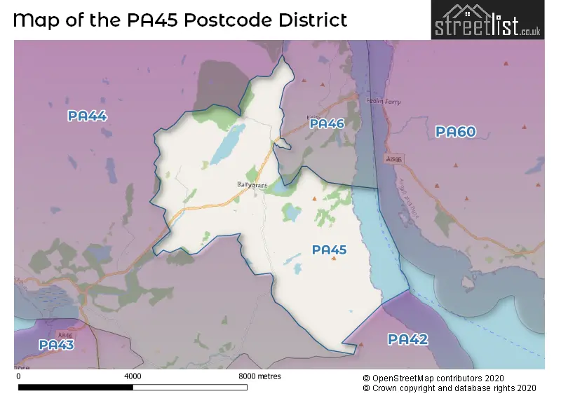
The PA45 Postcode shares a border with PA44 (Bridgend, Gruinart) and PA46 (Port Askaig, Keills, Bunnahabhain).
The primary settlement in the PA45 postcode district is Ballygrant, located in the county of Argyll and Bute in Scotland. Additionally, there are other significant settlements within this postcode district.
For the district PA45, we have data on 1 postcode sectors. Here's a breakdown: The sector PA45 7 is non-geographic. It's often designated for PO Boxes, large organisations, or special services.
PA45 Postcode Sectors


Map of the PA45 Postcode District
Explore the PA45 postcode district by using our free interactive map.
When it comes to local government, postal geography often disregards political borders. However, for a breakdown in the PA45 District: the district mostly encompasses the Argyll and Bute area with a total of 6 postcodes.
Where is the PA45 Postcode District?
The data shows that the postcode district PA45 is located in the town of Isle of Islay. Isle of Islay is situated in close proximity to several nearby towns, including Isle of Colonsay to the North, Isle of Gigha to the South East, Tarbert to the East, and Lochgilphead to the North East. Additionally, the distance from Isle of Islay to the center of London is approximately 386.71 miles.
The district is within the post town of ISLE OF ISLAY.
The sector has postcodes within the nation of Scotland.
The PA45 Postcode District is covers the following regions.
- Lochaber, Skye & Lochalsh, Arran & Cumbrae and Argyll & Bute - Highlands and Islands - Scotland
- East Dunbartonshire, West Dunbartonshire and Helensburgh & Lomond - West Central Scotland - Scotland
Weather Forecast for PA45
Press Button to Show Forecast for Ballygrant
| Time Period | Icon | Description | Temperature | Rain Probability | Wind |
|---|---|---|---|---|---|
| 15:00 to 18:00 | Partly cloudy (day) | 20.0°C (feels like 17.0°C) | 0.00% | SSE 13 mph | |
| 18:00 to 21:00 | Sunny day | 18.0°C (feels like 15.0°C) | 0.00% | SE 13 mph | |
| 21:00 to 00:00 | Clear night | 15.0°C (feels like 13.0°C) | 0.00% | SSE 11 mph |
Press Button to Show Forecast for Ballygrant
| Time Period | Icon | Description | Temperature | Rain Probability | Wind |
|---|---|---|---|---|---|
| 00:00 to 03:00 | Partly cloudy (night) | 14.0°C (feels like 12.0°C) | 0.00% | SE 11 mph | |
| 03:00 to 06:00 | Partly cloudy (night) | 14.0°C (feels like 12.0°C) | 1.00% | SE 11 mph | |
| 06:00 to 09:00 | Cloudy | 14.0°C (feels like 12.0°C) | 6.00% | SE 11 mph | |
| 09:00 to 12:00 | Cloudy | 15.0°C (feels like 12.0°C) | 6.00% | SE 13 mph | |
| 12:00 to 15:00 | Cloudy | 17.0°C (feels like 14.0°C) | 7.00% | SE 13 mph | |
| 15:00 to 18:00 | Cloudy | 17.0°C (feels like 14.0°C) | 10.00% | SSE 13 mph | |
| 18:00 to 21:00 | Cloudy | 15.0°C (feels like 14.0°C) | 15.00% | SSE 7 mph | |
| 21:00 to 00:00 | Light rain shower (night) | 13.0°C (feels like 12.0°C) | 36.00% | ESE 7 mph |
Press Button to Show Forecast for Ballygrant
| Time Period | Icon | Description | Temperature | Rain Probability | Wind |
|---|---|---|---|---|---|
| 00:00 to 03:00 | Light rain | 12.0°C (feels like 11.0°C) | 57.00% | ESE 7 mph | |
| 03:00 to 06:00 | Cloudy | 12.0°C (feels like 10.0°C) | 18.00% | ESE 7 mph | |
| 06:00 to 09:00 | Overcast | 12.0°C (feels like 10.0°C) | 21.00% | ESE 9 mph | |
| 09:00 to 12:00 | Overcast | 13.0°C (feels like 11.0°C) | 15.00% | ESE 11 mph | |
| 12:00 to 15:00 | Cloudy | 13.0°C (feels like 11.0°C) | 18.00% | SE 11 mph | |
| 15:00 to 18:00 | Cloudy | 14.0°C (feels like 12.0°C) | 19.00% | SE 11 mph | |
| 18:00 to 21:00 | Cloudy | 13.0°C (feels like 12.0°C) | 21.00% | SE 7 mph | |
| 21:00 to 00:00 | Light rain | 12.0°C (feels like 11.0°C) | 52.00% | ENE 7 mph |
Press Button to Show Forecast for Ballygrant
| Time Period | Icon | Description | Temperature | Rain Probability | Wind |
|---|---|---|---|---|---|
| 00:00 to 03:00 | Light rain | 12.0°C (feels like 11.0°C) | 59.00% | E 9 mph | |
| 03:00 to 06:00 | Heavy rain | 12.0°C (feels like 10.0°C) | 76.00% | E 9 mph | |
| 06:00 to 09:00 | Light rain | 12.0°C (feels like 10.0°C) | 53.00% | E 9 mph | |
| 09:00 to 12:00 | Light rain | 13.0°C (feels like 11.0°C) | 53.00% | ESE 11 mph | |
| 12:00 to 15:00 | Cloudy | 14.0°C (feels like 12.0°C) | 21.00% | ESE 11 mph | |
| 15:00 to 18:00 | Light rain shower (day) | 14.0°C (feels like 13.0°C) | 38.00% | S 11 mph | |
| 18:00 to 21:00 | Light rain shower (day) | 14.0°C (feels like 12.0°C) | 37.00% | SSW 9 mph | |
| 21:00 to 00:00 | Clear night | 12.0°C (feels like 11.0°C) | 13.00% | S 9 mph |
Press Button to Show Forecast for Ballygrant
| Time Period | Icon | Description | Temperature | Rain Probability | Wind |
|---|---|---|---|---|---|
| 00:00 to 03:00 | Cloudy | 11.0°C (feels like 10.0°C) | 13.00% | SE 9 mph | |
| 03:00 to 06:00 | Clear night | 11.0°C (feels like 9.0°C) | 11.00% | SSW 9 mph | |
| 06:00 to 09:00 | Partly cloudy (day) | 11.0°C (feels like 10.0°C) | 13.00% | SW 11 mph | |
| 09:00 to 12:00 | Partly cloudy (day) | 13.0°C (feels like 10.0°C) | 16.00% | E 11 mph | |
| 12:00 to 15:00 | Light rain shower (day) | 14.0°C (feels like 12.0°C) | 34.00% | SW 13 mph | |
| 15:00 to 18:00 | Partly cloudy (day) | 14.0°C (feels like 12.0°C) | 11.00% | SW 11 mph | |
| 18:00 to 21:00 | Sunny day | 14.0°C (feels like 12.0°C) | 9.00% | W 11 mph | |
| 21:00 to 00:00 | Clear night | 12.0°C (feels like 10.0°C) | 4.00% | W 9 mph |
Postcode Sectors within the PA45 District
| Postcode Sector | Delivery Office |
|---|---|
| PA45 7 | Ballygrant Scale Payment Delivery Office |
| P | A | 4 | 5 | - | X | X | X |
| P | A | 4 | 5 | Space | Numeric | Letter | Letter |
Current Monthly Rental Prices
| # Bedrooms | Min Price | Max Price | Avg Price |
|---|
Current House Prices
| # Bedrooms | Min Price | Max Price | Avg Price |
|---|
Estate Agents who Operate in the PA45 District
| Logo | Name | Brand Name | Address | Contact Number | Total Properties |
|---|