The PE12 9 postcode sector stands on the Lincolnshire and Norfolk border.
Did you know? According to the 2021 Census, the PE12 9 postcode sector is home to a bustling 11,622 residents!
Given that each sector allows for 400 unique postcode combinations. Letters C, I, K, M, O and V are not allowed in the last two letters of a postcode. With 296 postcodes already in use, this leaves 104 units available.
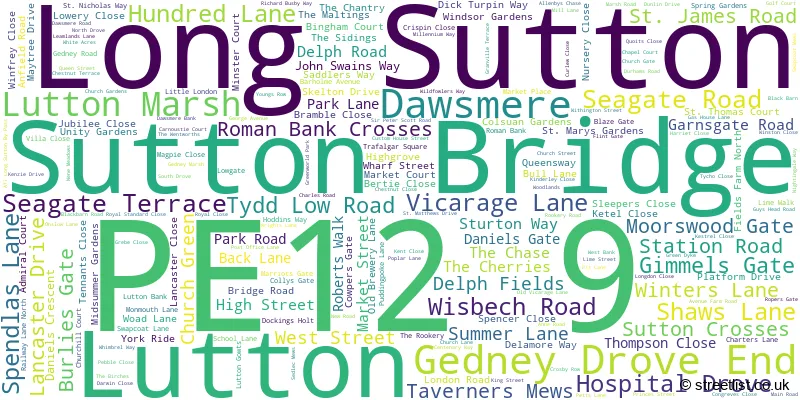
The largest settlement in the PE12 9 postal code is Long Sutton followed by Sutton Bridge, and Lutton.
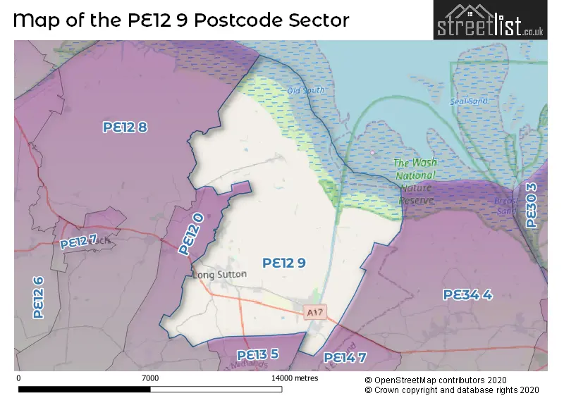
The PE12 9 Postcode shares a border with PE13 5 (Leverington, Tydd St. Giles, Newton-in-the-Isle), PE34 4 (Terrington St. Clement, Clenchwarton, Tilney St. Lawrence), PE12 0 (Sutton St. James, Gedney, Gedney Hill), PE12 8 (Holbeach, Holbeach St. Matthews) and PE14 7 (Walpole St. Andrew, WISBECH, Walton Highway).
The sector is within the post town of SPALDING.
PE12 9 is a postcode sector within the PE12 postcode district which is within the PE Peterborough postcode area.
The Royal Mail delivery office for the PE12 9 postal sector is the Holbeach Delivery Office and Spalding Delivery Office and Long Sutton Scale Payment Delivery Office and Sutton Bridge Scale Payment Delivery Office.
The area of the PE12 9 postcode sector is 37.97 square miles which is 98.35 square kilometres or 24,302.85 square acres.
Waterways within the PE12 9 postcode sector include the River Nene, South Holland Main Drain.

Map of the PE12 9 Postcode Sector
Explore the PE12 9 postcode sector by using our free interactive map.
| P | E | 1 | 2 | - | 9 | X | X |
| P | E | 1 | 2 | Space | 9 | Letter | Letter |
Official List of Streets
Long Sutton (100 Streets)
Sutton Bridge (65 Streets)
Lutton (29 Streets)
Gedney Drove End (10 Streets)
Dawsmere (4 Streets)
Unofficial Streets or Alternative Spellings
Gedney
BLAZEGATE GREEN DYKE MAIN ROAD MIDDLE DROVE ROPERS GATEHolbeach St. Matthews
SOTS HOLE BANKWeather Forecast for PE12 9
Press Button to Show Forecast for Long Sutton
| Time Period | Icon | Description | Temperature | Rain Probability | Wind |
|---|---|---|---|---|---|
| 06:00 to 09:00 | Cloudy | 7.0°C (feels like 4.0°C) | 9.00% | ENE 9 mph | |
| 09:00 to 12:00 | Cloudy | 9.0°C (feels like 6.0°C) | 17.00% | ENE 11 mph | |
| 12:00 to 15:00 | Cloudy | 9.0°C (feels like 6.0°C) | 49.00% | NE 13 mph | |
| 15:00 to 18:00 | Overcast | 9.0°C (feels like 5.0°C) | 12.00% | NE 13 mph | |
| 18:00 to 21:00 | Overcast | 8.0°C (feels like 4.0°C) | 12.00% | NE 16 mph | |
| 21:00 to 00:00 | Overcast | 8.0°C (feels like 4.0°C) | 11.00% | NE 13 mph |
Press Button to Show Forecast for Long Sutton
| Time Period | Icon | Description | Temperature | Rain Probability | Wind |
|---|---|---|---|---|---|
| 00:00 to 03:00 | Heavy rain | 8.0°C (feels like 4.0°C) | 81.00% | NNE 16 mph | |
| 03:00 to 06:00 | Heavy rain | 8.0°C (feels like 4.0°C) | 90.00% | NNE 18 mph | |
| 06:00 to 09:00 | Heavy rain | 8.0°C (feels like 5.0°C) | 93.00% | NNE 16 mph | |
| 09:00 to 12:00 | Heavy rain | 9.0°C (feels like 6.0°C) | 81.00% | NW 11 mph | |
| 12:00 to 15:00 | Heavy rain | 9.0°C (feels like 5.0°C) | 79.00% | WNW 13 mph | |
| 15:00 to 18:00 | Overcast | 9.0°C (feels like 6.0°C) | 22.00% | WNW 13 mph | |
| 18:00 to 21:00 | Cloudy | 9.0°C (feels like 7.0°C) | 11.00% | WSW 9 mph | |
| 21:00 to 00:00 | Partly cloudy (night) | 7.0°C (feels like 5.0°C) | 2.00% | SW 9 mph |
Press Button to Show Forecast for Long Sutton
| Time Period | Icon | Description | Temperature | Rain Probability | Wind |
|---|---|---|---|---|---|
| 00:00 to 03:00 | Clear night | 6.0°C (feels like 4.0°C) | 2.00% | SW 9 mph | |
| 03:00 to 06:00 | Clear night | 5.0°C (feels like 2.0°C) | 1.00% | SSW 7 mph | |
| 06:00 to 09:00 | Sunny day | 6.0°C (feels like 3.0°C) | 1.00% | S 9 mph | |
| 09:00 to 12:00 | Sunny day | 11.0°C (feels like 9.0°C) | 1.00% | S 11 mph | |
| 12:00 to 15:00 | Cloudy | 13.0°C (feels like 11.0°C) | 6.00% | S 13 mph | |
| 15:00 to 18:00 | Cloudy | 14.0°C (feels like 12.0°C) | 6.00% | S 11 mph | |
| 18:00 to 21:00 | Sunny day | 13.0°C (feels like 11.0°C) | 1.00% | SSE 11 mph | |
| 21:00 to 00:00 | Clear night | 10.0°C (feels like 7.0°C) | 1.00% | SE 9 mph |
Press Button to Show Forecast for Long Sutton
| Time Period | Icon | Description | Temperature | Rain Probability | Wind |
|---|---|---|---|---|---|
| 00:00 to 03:00 | Clear night | 8.0°C (feels like 6.0°C) | 1.00% | SE 9 mph | |
| 03:00 to 06:00 | Clear night | 7.0°C (feels like 5.0°C) | 2.00% | SE 9 mph | |
| 06:00 to 09:00 | Partly cloudy (day) | 8.0°C (feels like 6.0°C) | 5.00% | ESE 9 mph | |
| 09:00 to 12:00 | Cloudy | 13.0°C (feels like 11.0°C) | 7.00% | ESE 9 mph | |
| 12:00 to 15:00 | Cloudy | 15.0°C (feels like 13.0°C) | 9.00% | ESE 11 mph | |
| 15:00 to 18:00 | Cloudy | 14.0°C (feels like 12.0°C) | 8.00% | E 11 mph | |
| 18:00 to 21:00 | Cloudy | 13.0°C (feels like 12.0°C) | 7.00% | E 9 mph | |
| 21:00 to 00:00 | Cloudy | 12.0°C (feels like 10.0°C) | 15.00% | E 9 mph |
Schools and Places of Education Within the PE12 9 Postcode Sector
Gedney Drove End Primary School
Community school
Main Road, Spalding, Lincolnshire, PE12 9PD
Head: Miss Karyn Wiles
Ofsted Rating: Requires improvement
Inspection: 2022-05-25 (703 days ago)
Website: Visit Gedney Drove End Primary School Website
Phone: 01406550242
Number of Pupils: 37
Lutton St Nicholas Primary Academy
Academy converter
Lutton, Spalding, Lincolnshire, PE12 9HN
Head: Mr Jacob Perrin
Ofsted Rating: Good
Inspection: 2023-07-04 (298 days ago)
Website: Visit Lutton St Nicholas Primary Academy Website
Phone: 01406363392
Number of Pupils: 99
Sutton Bridge Westmere Community Primary School
Community school
Anne Road, Spalding, Lincolnshire, PE12 9TB
Head: Mrs Karyn Herd
Ofsted Rating: Good
Inspection: 2021-11-24 (885 days ago)
Website: Visit Sutton Bridge Westmere Community Primary School Website
Phone: 01406350205
Number of Pupils: 236
University Academy Long Sutton
Academy sponsor led
84 Little London, Spalding, Lincolnshire, PE12 9LF
Head: Mr Liam Dav�
Ofsted Rating: Requires improvement
Inspection: 2023-09-27 (213 days ago)
Website: Visit University Academy Long Sutton Website
Phone: 01406362120
Number of Pupils: 703
House Prices in the PE12 9 Postcode Sector
| Type of Property | 2018 Average | 2018 Sales | 2017 Average | 2017 Sales | 2016 Average | 2016 Sales | 2015 Average | 2015 Sales |
|---|---|---|---|---|---|---|---|---|
| Detached | £218,897 | 137 | £215,336 | 115 | £188,524 | 116 | £184,588 | 122 |
| Semi-Detached | £146,489 | 51 | £141,195 | 65 | £132,691 | 59 | £128,299 | 65 |
| Terraced | £118,000 | 42 | £121,124 | 63 | £112,882 | 39 | £105,695 | 41 |
| Flats | £86,167 | 3 | £75,510 | 5 | £83,579 | 7 | £69,333 | 6 |
Important Postcodes PE12 9 in the Postcode Sector
PE12 9BP is the postcode for Lincolnshire Fire & Rescue Service, Fire Station, Station Road
PE12 9EP is the postcode for Long Sutton Primary School, Dick Turpin Way
PE12 9HB is the postcode for Long Sutton Medical Centre, Trafalgar Square, Long Sutton, and Long Sutton Medical Centre, Trafalgar Square
PE12 9HD is the postcode for Lincolnshire County Council, Long Sutton Library, Swapcoat Lane
PE12 9HN is the postcode for Lutton St. Nicholas Primary School, Marriots Gate
PE12 9LF is the postcode for Peele Leisure Centre, Little London, UNIVERSITY ACADEMY LONG SUTTON, 84 LITTLE LONDON, LONG SUTTON, and The Peele Community College, 84 Little London
PE12 9PD is the postcode for G D E Primary School, Main Road
PE12 9TB is the postcode for SUTTON BRIDGE WESTMERE COMMUNITY PRIMARY SCHOOL, ANNE ROAD, SUTTON BRIDGE, Sunbeams Playgroup, Anne Road, Sutton Bridge Westmere Primary School, Anne Road, Sutton Bridge, and Sutton Bridge Westmere Primary School, Anne Road
PE12 9UZ is the postcode for Sutton Bridge Medical Centre, Railway Lane
| The PE12 9 Sector is within these Local Authorities |
|
|---|---|
| The PE12 9 Sector is within these Counties |
|
| The PE12 9 Sector is within these Water Company Areas |
|