The PE8 5 postcode sector stands on the Northamptonshire and Cambridgeshire border.
Did you know? According to the 2021 Census, the PE8 5 postcode sector is home to a bustling 3,930 residents!
Given that each sector allows for 400 unique postcode combinations. Letters C, I, K, M, O and V are not allowed in the last two letters of a postcode. With 175 postcodes already in use, this leaves 225 units available.
The largest settlement in the PE8 5 postal code is Barnwell followed by Oundle, and Polebrook.
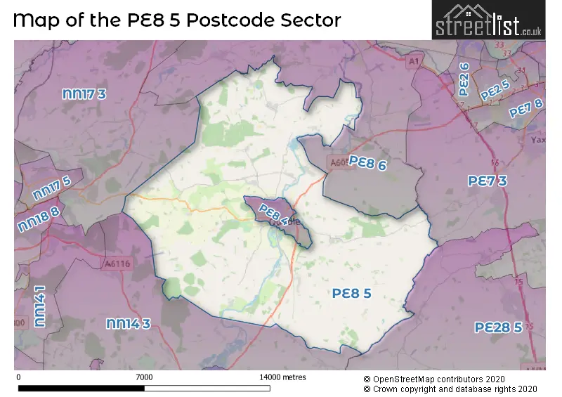
The PE8 5 Postcode shares a border with PE7 3 (Yaxley, Farcet, Stilton), PE28 5 (Sawtry, Glatton, Woodwalton), NN14 3 (Brigstock, Islip, Titchmarsh), NN17 3 (Weldon, Gretton, Harringworth), PE8 4 (Oundle) and PE8 6 (Wittering, Kings Cliffe, Warmington).
The sector is within the post town of PETERBOROUGH.
PE8 5 is a postcode sector within the PE8 postcode district which is within the PE Peterborough postcode area.
The Royal Mail delivery office for the PE8 5 postal sector is the Oundle Delivery Office.
The area of the PE8 5 postcode sector is 60.25 square miles which is 156.04 square kilometres or 38,557.81 square acres.
Waterways within the PE8 5 postcode sector include the River Nene.

Map of the PE8 5 Postcode Sector
Explore the PE8 5 postcode sector by using our free interactive map.
| P | E | 8 | - | 5 | X | X |
| P | E | 8 | Space | 5 | Letter | Letter |
Official List of Streets
Barnwell (9 Streets)
Upper Benefield (7 Streets)
Ashton (1 Streets)
Oundle (9 Streets)
Thurning (5 Streets)
Glapthorn (5 Streets)
Apethorpe (5 Streets)
Southwick (4 Streets)
Stoke Doyle (2 Streets)
Polebrook (13 Streets)
Wadenhoe (6 Streets)
Fotheringhay (2 Streets)
Tansor (3 Streets)
Elmington (1 Streets)
Lutton (2 Streets)
Woodnewton (13 Streets)
Hemington (1 Streets)
Cotterstock (2 Streets)
Lower Benefield (1 Streets)
Luddington (1 Streets)
Unofficial Streets or Alternative Spellings
Great Gidding
HEMINGTON LODGE ROAD LUDDINGTON ROADWinwick
THURNING ROADOundle
MILL ROAD STATION ROADThorpe Waterville
LILFORD ROADAldwincle
WADENHOE ROADBrigstock
HARLEY WAYNassington
APETHORPE ROAD WOODNEWTON ROADWeldon
OUNDLE ROADWeather Forecast for PE8 5
Press Button to Show Forecast for Oundle
| Time Period | Icon | Description | Temperature | Rain Probability | Wind |
|---|---|---|---|---|---|
| 03:00 to 06:00 | Cloudy | 4.0°C (feels like 2.0°C) | 8.00% | NE 4 mph | |
| 06:00 to 09:00 | Cloudy | 5.0°C (feels like 3.0°C) | 11.00% | NE 7 mph | |
| 09:00 to 12:00 | Cloudy | 8.0°C (feels like 5.0°C) | 15.00% | ENE 11 mph | |
| 12:00 to 15:00 | Overcast | 9.0°C (feels like 6.0°C) | 17.00% | NE 11 mph | |
| 15:00 to 18:00 | Overcast | 9.0°C (feels like 6.0°C) | 14.00% | NE 13 mph | |
| 18:00 to 21:00 | Overcast | 8.0°C (feels like 5.0°C) | 12.00% | NE 11 mph | |
| 21:00 to 00:00 | Overcast | 7.0°C (feels like 4.0°C) | 21.00% | NNE 11 mph |
Press Button to Show Forecast for Oundle
| Time Period | Icon | Description | Temperature | Rain Probability | Wind |
|---|---|---|---|---|---|
| 00:00 to 03:00 | Heavy rain | 7.0°C (feels like 4.0°C) | 80.00% | NNE 13 mph | |
| 03:00 to 06:00 | Heavy rain | 7.0°C (feels like 3.0°C) | 90.00% | NNE 13 mph | |
| 06:00 to 09:00 | Heavy rain | 7.0°C (feels like 4.0°C) | 92.00% | N 13 mph | |
| 09:00 to 12:00 | Heavy rain | 8.0°C (feels like 5.0°C) | 81.00% | NNW 11 mph | |
| 12:00 to 15:00 | Light rain | 8.0°C (feels like 5.0°C) | 58.00% | NW 13 mph | |
| 15:00 to 18:00 | Cloudy | 9.0°C (feels like 7.0°C) | 16.00% | WNW 9 mph | |
| 18:00 to 21:00 | Partly cloudy (day) | 10.0°C (feels like 8.0°C) | 6.00% | WSW 7 mph | |
| 21:00 to 00:00 | Partly cloudy (night) | 7.0°C (feels like 5.0°C) | 3.00% | SW 7 mph |
Press Button to Show Forecast for Oundle
| Time Period | Icon | Description | Temperature | Rain Probability | Wind |
|---|---|---|---|---|---|
| 00:00 to 03:00 | Clear night | 6.0°C (feels like 3.0°C) | 2.00% | SW 7 mph | |
| 03:00 to 06:00 | Clear night | 4.0°C (feels like 2.0°C) | 1.00% | SSW 7 mph | |
| 06:00 to 09:00 | Sunny day | 5.0°C (feels like 3.0°C) | 1.00% | S 7 mph | |
| 09:00 to 12:00 | Partly cloudy (day) | 11.0°C (feels like 9.0°C) | 1.00% | SSW 11 mph | |
| 12:00 to 15:00 | Overcast | 14.0°C (feels like 11.0°C) | 8.00% | S 13 mph | |
| 15:00 to 18:00 | Partly cloudy (day) | 15.0°C (feels like 12.0°C) | 1.00% | S 11 mph | |
| 18:00 to 21:00 | Sunny day | 13.0°C (feels like 11.0°C) | 1.00% | S 9 mph | |
| 21:00 to 00:00 | Clear night | 9.0°C (feels like 7.0°C) | 1.00% | SSE 9 mph |
Press Button to Show Forecast for Oundle
| Time Period | Icon | Description | Temperature | Rain Probability | Wind |
|---|---|---|---|---|---|
| 00:00 to 03:00 | Clear night | 7.0°C (feels like 5.0°C) | 2.00% | SE 7 mph | |
| 03:00 to 06:00 | Clear night | 6.0°C (feels like 4.0°C) | 3.00% | ESE 7 mph | |
| 06:00 to 09:00 | Sunny day | 8.0°C (feels like 6.0°C) | 5.00% | ESE 7 mph | |
| 09:00 to 12:00 | Partly cloudy (day) | 13.0°C (feels like 11.0°C) | 3.00% | ESE 9 mph | |
| 12:00 to 15:00 | Partly cloudy (day) | 16.0°C (feels like 13.0°C) | 6.00% | SE 11 mph | |
| 15:00 to 18:00 | Cloudy | 16.0°C (feels like 14.0°C) | 14.00% | ESE 9 mph | |
| 18:00 to 21:00 | Cloudy | 15.0°C (feels like 13.0°C) | 9.00% | ESE 9 mph | |
| 21:00 to 00:00 | Cloudy | 11.0°C (feels like 10.0°C) | 11.00% | E 7 mph |
Schools and Places of Education Within the PE8 5 Postcode Sector
Glapthorn Church of England Primary School
Academy converter
Glapthorn, Peterborough, Northamptonshire, PE8 5BQ
Head: Mrs Lou Coulthard
Ofsted Rating: Good
Inspection: 2023-03-14 (410 days ago)
Website: Visit Glapthorn Church of England Primary School Website
Phone: 01832273452
Number of Pupils: 75
Oundle Church of England Primary School
Academy converter
Cotterstock Road, Peterborough, Northamptonshire, PE8 5HA
Head: Mrs Joanne Griffin
Ofsted Rating: Good
Inspection: 2023-11-29 (150 days ago)
Website: Visit Oundle Church of England Primary School Website
Phone: 01832272392
Number of Pupils: 366
Polebrook Church of England Primary School
Academy converter
Main Street, Peterborough, Cambridgeshire, PE8 5LN
Head: Mrs Lou Coulthard
Ofsted Rating: Good
Inspection: 2023-09-20 (220 days ago)
Website: Visit Polebrook Church of England Primary School Website
Phone: 01832272319
Number of Pupils: 89
House Prices in the PE8 5 Postcode Sector
| Type of Property | 2018 Average | 2018 Sales | 2017 Average | 2017 Sales | 2016 Average | 2016 Sales | 2015 Average | 2015 Sales |
|---|---|---|---|---|---|---|---|---|
| Detached | £550,167 | 32 | £549,171 | 38 | £449,277 | 37 | £456,585 | 23 |
| Semi-Detached | £374,288 | 13 | £311,786 | 7 | £356,833 | 9 | £310,787 | 19 |
| Terraced | £331,167 | 6 | £357,923 | 13 | £209,211 | 14 | £237,682 | 11 |
| Flats | £0 | 0 | £0 | 0 | £78,350 | 2 | £0 | 0 |
Important Postcodes PE8 5 in the Postcode Sector
PE8 5BQ is the postcode for Glapthorn C of E Primary School, Glapthorn
PE8 5HA is the postcode for Oundle & Kings Cliffe Middle School, Cotterstock Road, Oundle C of E Primary School, Cotterstock Road, and Oundle C of E Primary School, Cotterstock Road, Oundle
PE8 5LN is the postcode for Polebrook School, Main Street
| The PE8 5 Sector is within these Local Authorities |
|
|---|---|
| The PE8 5 Sector is within these Counties |
|
| The PE8 5 Sector is within these Water Company Areas |
|
Tourist Attractions within the PE8 5 Postcode Area
We found 2 visitor attractions within the PE8 postcode area
| Lyveden New Bield |
|---|
| Historic Properties |
| Historic House / House and Garden / Palace |
| View Lyveden New Bield on Google Maps |
| Apethorpe Hall |
| Historic Properties |
| Historic House / House and Garden / Palace |
| View Apethorpe Hall on Google Maps |