The PL7 5 postcode sector is within the county of Devon.
Did you know? According to the 2021 Census, the PL7 5 postcode sector is home to a bustling 2,665 residents!
Given that each sector allows for 400 unique postcode combinations. Letters C, I, K, M, O and V are not allowed in the last two letters of a postcode. With 122 postcodes already in use, this leaves 278 units available.
The largest settlement in the PL7 5 postal code is Plympton followed by PLYMOUTH, and Sparkwell.
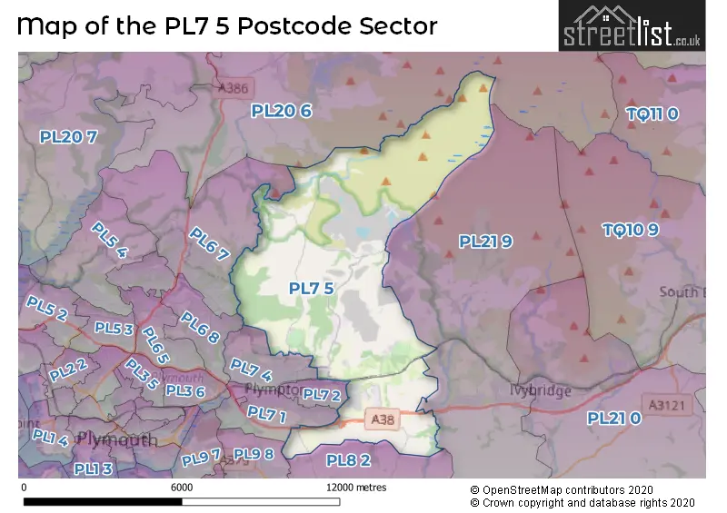
The PL7 5 Postcode shares a border with PL21 9 (IVYBRIDGE, Cornwood, Woodlands), PL6 7 (PLYMOUTH, Roborough, Glenholt Park), PL6 8 (PLYMOUTH, Derriford), PL9 8 (PLYMOUTH, Sherford, Plymstock), PL7 1 (PLYMOUTH, Plympton), PL7 2 (PLYMOUTH, Plympton, Chaddlewood), PL7 4 (PLYMOUTH, Plympton), PL8 2 (Yealmpton, Brixton) and PL20 6 (YELVERTON, Princetown, Dousland).
The sector is within the post town of PLYMOUTH.
PL7 5 is a postcode sector within the PL21 postcode district which is within the PL Plymouth postcode area.
The Royal Mail delivery office for the PL7 5 postal sector is the unknown.
The area of the PL7 5 postcode sector is 25.93 square miles which is 67.15 square kilometres or 16,593.47 square acres.
The PL7 5 postcode sector is crossed by the A38 Major A road.
Waterways within the PL7 5 postcode sector include the River Plym, River Yealm, River Meavy, Tory Brook.


Map of the PL7 5 Postcode Sector
Explore the PL7 5 postcode sector by using our free interactive map.
| P | L | 7 | - | 5 | X | X |
| P | L | 7 | Space | 5 | Letter | Letter |
Official List of Streets
Plympton (14 Streets)
Sparkwell (8 Streets)
PLYMOUTH (9 Streets)
Lee Moor (9 Streets)
Wotter (3 Streets)
Smithaleigh (2 Streets)
Hemerdon (1 Streets)
Unofficial Streets or Alternative Spellings
Lee Mill Bridge
NEW PARK ROADPlympton
RIDGE ROAD RIDGEWAY VINERY LANEPLYMOUTH
BORINGDON HILL NEWNHAM ROAD STOGGY LANESherford
ARIES LANE HERCULES ROAD LYNX LANESchools and Places of Education Within the PL7 5 Postcode Sector
Shaugh Prior Primary School
Community school
Shaugh Prior, Plymouth, Devon, PL7 5HA
Head: Mrs Sara-Jane Baker
Ofsted Rating: Requires improvement
Inspection: 2022-07-13 (695 days ago)
Website: Visit Shaugh Prior Primary School Website
Phone: 01752839373
Number of Pupils: 28
Sparkwell All Saints Primary School
Free schools
, Plymouth, Devon, PL7 5DD
Head: Mrs Francesca McLoughlin
Ofsted Rating: Good
Inspection: 2019-01-22 (1963 days ago)
Website: Visit Sparkwell All Saints Primary School Website
Phone: 01752878855
Number of Pupils: 97
House Prices in the PL7 5 Postcode Sector
| Type of Property | 2018 Average | 2018 Sales | 2017 Average | 2017 Sales | 2016 Average | 2016 Sales | 2015 Average | 2015 Sales |
|---|---|---|---|---|---|---|---|---|
| Detached | £355,313 | 16 | £330,791 | 17 | £354,577 | 13 | £303,967 | 15 |
| Semi-Detached | £203,718 | 11 | £208,714 | 7 | £198,500 | 6 | £202,143 | 7 |
| Terraced | £190,050 | 10 | £183,093 | 12 | £164,586 | 11 | £172,736 | 21 |
| Flats | £142,333 | 3 | £130,000 | 1 | £0 | 0 | £0 | 0 |
| The PL7 5 Sector is within these Local Authorities |
|
|---|---|
| The PL7 5 Sector is within these Counties |
|
| The PL7 5 Sector is within these Water Company Areas |
|