The PL32 9 postcode sector is within the county of Cornwall.
Did you know? According to the 2021 Census, the PL32 9 postcode sector is home to a bustling 4,588 residents!
Given that each sector allows for 400 unique postcode combinations. Letters C, I, K, M, O and V are not allowed in the last two letters of a postcode. With 166 postcodes already in use, this leaves 234 units available.
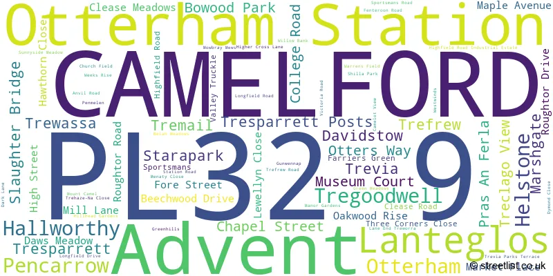
The largest settlement in the PL32 9 postal code is CAMELFORD followed by Davidstow, and Advent.
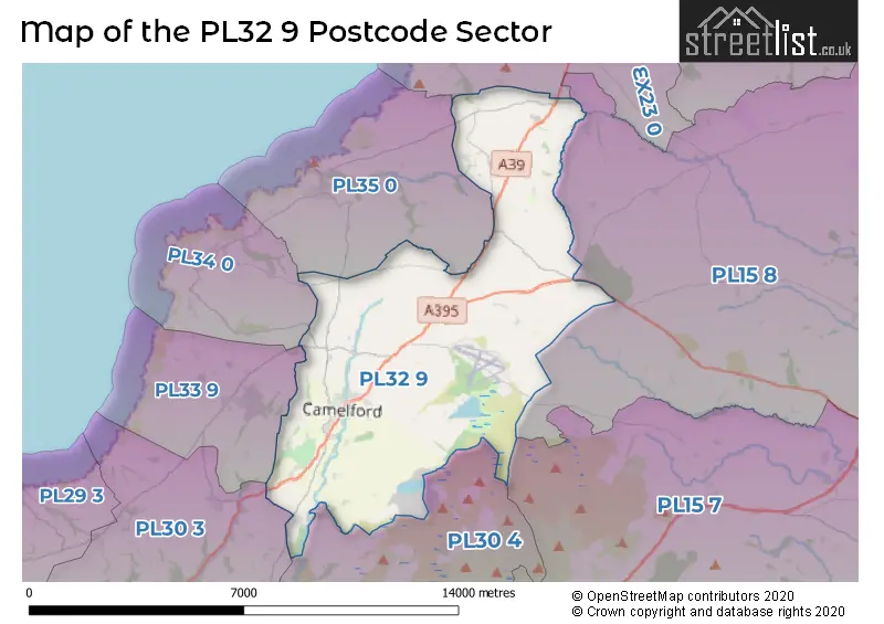
The PL32 9 Postcode shares a border with PL30 3 (St. Teath, St. Tudy, St. Mabyn), PL30 4 (St. Breward, Blisland, Cardinham), PL33 9 (DELABOLE, West Downs, Treligga), PL34 0 (TINTAGEL, Treknow, Trethevy), PL35 0 (BOSCASTLE, St. Juliot, Minster), PL15 7 (LAUNCESTON, Altarnun, South Petherwin), PL15 8 (LAUNCESTON, Egloskerry, North Petherwin) and EX23 0 (Marhamchurch, Poundstock, Widemouth Bay).
The sector is within the post town of CAMELFORD.
PL32 9 is a postcode sector within the PL3 postcode district which is within the PL Plymouth postcode area.
The Royal Mail delivery office for the PL32 9 postal sector is the unknown.
The area of the PL32 9 postcode sector is 31.23 square miles which is 80.89 square kilometres or 19,988.95 square acres.
Waterways within the PL32 9 postcode sector include the River Camel.

Map of the PL32 9 Postcode Sector
Explore the PL32 9 postcode sector by using our free interactive map.
| P | L | 3 | 2 | - | 9 | X | X |
| P | L | 3 | 2 | Space | 9 | Letter | Letter |
Official List of Streets
CAMELFORD (47 Streets)
Otterham (2 Streets)
Lanteglos (1 Streets)
Tresparrett (2 Streets)
Davidstow (1 Streets)
Otterham Station (1 Streets)
Tregoodwell (1 Streets)
Helstone (1 Streets)
Unofficial Streets or Alternative Spellings
Weather Forecast for PL32 9
Press Button to Show Forecast for Camelford
| Time Period | Icon | Description | Temperature | Rain Probability | Wind |
|---|---|---|---|---|---|
| 03:00 to 06:00 | Heavy rain | 9.0°C (feels like 6.0°C) | 90.00% | S 20 mph | |
| 06:00 to 09:00 | Heavy rain | 9.0°C (feels like 5.0°C) | 92.00% | SSE 20 mph | |
| 09:00 to 12:00 | Heavy rain | 9.0°C (feels like 6.0°C) | 90.00% | S 13 mph | |
| 12:00 to 15:00 | Heavy rain | 10.0°C (feels like 7.0°C) | 81.00% | S 11 mph | |
| 15:00 to 18:00 | Light rain | 10.0°C (feels like 7.0°C) | 53.00% | S 11 mph | |
| 18:00 to 21:00 | Partly cloudy (day) | 9.0°C (feels like 7.0°C) | 9.00% | S 9 mph | |
| 21:00 to 00:00 | Partly cloudy (night) | 7.0°C (feels like 4.0°C) | 4.00% | SSE 9 mph |
Press Button to Show Forecast for Camelford
| Time Period | Icon | Description | Temperature | Rain Probability | Wind |
|---|---|---|---|---|---|
| 00:00 to 03:00 | Partly cloudy (night) | 7.0°C (feels like 4.0°C) | 2.00% | SSE 9 mph | |
| 03:00 to 06:00 | Partly cloudy (night) | 6.0°C (feels like 3.0°C) | 1.00% | SSE 9 mph | |
| 06:00 to 09:00 | Cloudy | 7.0°C (feels like 5.0°C) | 5.00% | SE 7 mph | |
| 09:00 to 12:00 | Cloudy | 10.0°C (feels like 8.0°C) | 6.00% | SSE 9 mph | |
| 12:00 to 15:00 | Cloudy | 11.0°C (feels like 9.0°C) | 6.00% | SSE 9 mph | |
| 15:00 to 18:00 | Cloudy | 11.0°C (feels like 10.0°C) | 11.00% | SW 7 mph | |
| 18:00 to 21:00 | Cloudy | 10.0°C (feels like 9.0°C) | 11.00% | W 4 mph | |
| 21:00 to 00:00 | Cloudy | 7.0°C (feels like 5.0°C) | 13.00% | NNE 4 mph |
Press Button to Show Forecast for Camelford
| Time Period | Icon | Description | Temperature | Rain Probability | Wind |
|---|---|---|---|---|---|
| 00:00 to 03:00 | Partly cloudy (night) | 6.0°C (feels like 4.0°C) | 15.00% | N 4 mph | |
| 03:00 to 06:00 | Cloudy | 5.0°C (feels like 3.0°C) | 19.00% | N 7 mph | |
| 06:00 to 09:00 | Cloudy | 6.0°C (feels like 4.0°C) | 20.00% | NNW 7 mph | |
| 09:00 to 12:00 | Cloudy | 10.0°C (feels like 8.0°C) | 22.00% | NW 9 mph | |
| 12:00 to 15:00 | Light rain | 11.0°C (feels like 9.0°C) | 47.00% | NW 11 mph | |
| 15:00 to 18:00 | Partly cloudy (day) | 12.0°C (feels like 10.0°C) | 14.00% | NW 11 mph | |
| 18:00 to 21:00 | Cloudy | 11.0°C (feels like 9.0°C) | 13.00% | NW 9 mph | |
| 21:00 to 00:00 | Cloudy | 9.0°C (feels like 7.0°C) | 12.00% | NW 9 mph |
Schools and Places of Education Within the PL32 9 Postcode Sector
Camelford Community Primary School
Academy converter
Station Road, Camelford, Cornwall, PL32 9UE
Head: Mrs Anne Howard
Ofsted Rating: Good
Inspection: 2023-12-07 (145 days ago)
Website: Visit Camelford Community Primary School Website
Phone: 01840212376
Number of Pupils: 304
Otterham Community Primary School
Academy converter
Marshgate, Camelford, Cornwall, PL32 9YW
Head: Mrs H Ward
Ofsted Rating: Good
Inspection: 2023-02-02 (453 days ago)
Website: Visit Otterham Community Primary School Website
Phone: 01840261344
Number of Pupils: 70
Sir James Smith's School
Academy converter
Dark Lane, Camelford, Cornwall, PL32 9UJ
Head: Mr Marc Cooper
Ofsted Rating: Good
Inspection: 2022-10-12 (566 days ago)
Website: Visit Sir James Smith's School Website
Phone: 01840213274
Number of Pupils: 601
House Prices in the PL32 9 Postcode Sector
| Type of Property | 2018 Average | 2018 Sales | 2017 Average | 2017 Sales | 2016 Average | 2016 Sales | 2015 Average | 2015 Sales |
|---|---|---|---|---|---|---|---|---|
| Detached | £270,045 | 44 | £283,506 | 45 | £300,224 | 40 | £242,641 | 28 |
| Semi-Detached | £190,622 | 19 | £168,097 | 18 | £202,897 | 17 | £186,294 | 17 |
| Terraced | £167,128 | 23 | £155,933 | 15 | £143,593 | 21 | £142,223 | 23 |
| Flats | £86,000 | 2 | £75,000 | 1 | £78,500 | 4 | £130,000 | 2 |
Important Postcodes PL32 9 in the Postcode Sector
PL32 9QZ is the postcode for Camelford Primary School, Highfield Road
PL32 9UE is the postcode for CAMELFORD JUNIOR AND INFANT SCHOOL, STATION ROAD, CAMELFORD, Camelford Leisure Centre, Sportsmans Road, Camelford Community Primary School, Station Road, and Camelford Leisure Centre, Sportsmans
PL32 9UJ is the postcode for Sir James Smiths Community School, Dark Lane, OLD SIXTH FORM BLOCK, Sir James Smiths Community School, Dark Lane, MATHS BLOCK, Sir James Smiths Community School, Dark Lane, TECHNOLOGY BLOCK, Sir James Smiths Community School, Dark Lane, and ADULT EDUCATION BLOCK, Sir James Smiths Community School, Dark Lane
PL32 9YW is the postcode for Otterham Cp School, Marshgate
| The PL32 9 Sector is within these Local Authorities |
|
|---|---|
| The PL32 9 Sector is within these Counties |
|
| The PL32 9 Sector is within these Water Company Areas |
|