The PO15 5 postcode sector is within the county of Hampshire.
Did you know? According to the 2021 Census, the PO15 5 postcode sector is home to a bustling 7,023 residents!
Given that each sector allows for 400 unique postcode combinations. Letters C, I, K, M, O and V are not allowed in the last two letters of a postcode. With 234 postcodes already in use, this leaves 166 units available.
The largest settlements in the PO15 5 postal code are FAREHAM and Titchfield.
The PO15 5 Postcode shares a border with PO14 1 (FAREHAM), PO15 6 (FAREHAM, Titchfield), PO16 0 (FAREHAM), PO16 7 (FAREHAM), PO14 3 (FAREHAM, Stubbington), PO14 4 (FAREHAM, Titchfield), PO15 7 (Whiteley), SO31 1 (Park Gate, Bursledon, Burridge) and SO31 6 (Locks Heath, Park Gate).
The sector is within the post town of FAREHAM.
PO15 5 is a postcode sector within the PO14 postcode district which is within the PO Portsmouth postcode area.
The Royal Mail delivery office for the PO15 5 postal sector is the unknown.
The area of the PO15 5 postcode sector is 1.71 square miles which is 4.44 square kilometres or 1,097.06 square acres.
The PO15 5 postcode sector is crossed by the M27 motorway.
Waterways within the PO15 5 postcode sector include the Meon.

Map of the PO15 5 Postcode Sector
Explore the PO15 5 postcode sector by using our free interactive map.
| P | O | 1 | 5 | - | 5 | X | X |
| P | O | 1 | 5 | Space | 5 | Letter | Letter |
Official List of Streets
FAREHAM (105 Streets)
Segensworth West (1 Streets)
Unofficial Streets or Alternative Spellings
FAREHAM
BLACKBROOK HOUSE DRIVE FARM ROAD PEAK LANE SANDRINGHAM ROAD WHITELEY LANE WITHERBED LANE ADAMS WAY BARRATT INDUSTRIAL ESTATE BLACKBROOK BUSINESS PARK BRABAZON ROAD DRUMMOND ROAD FIRENZE FUNTLEY HILL GLOSTER COURT GRACEFIELDS MERE CROFT MILFORD RISE OAK COURT PARK GATE INTERCHANGE SEGENSWORTH LINK SEGENSWORTH ROAD EAST SEGENSWORTH ROUNDABOUT STONY BRIDGE WILDFLOWER DRIVETitchfield
FONTLEY ROAD THE AVENUEPark Gate
SOUTHAMPTON ROAD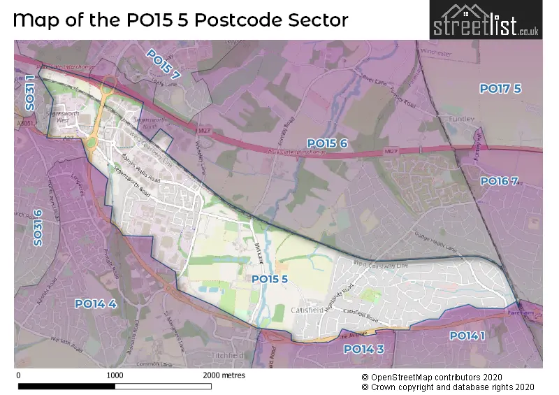
House Prices in the PO15 5 Postcode Sector
| Type of Property | 2018 Average | 2018 Sales | 2017 Average | 2017 Sales | 2016 Average | 2016 Sales | 2015 Average | 2015 Sales |
|---|---|---|---|---|---|---|---|---|
| Detached | £387,139 | 45 | £379,526 | 65 | £346,851 | 61 | £336,421 | 78 |
| Semi-Detached | £269,211 | 64 | £268,883 | 74 | £249,328 | 48 | £232,426 | 75 |
| Terraced | £275,000 | 13 | £263,661 | 9 | £241,639 | 14 | £241,994 | 8 |
| Flats | £179,667 | 6 | £177,563 | 16 | £180,042 | 12 | £164,000 | 15 |
Important Postcodes PO15 5 in the Postcode Sector
PO15 5TD is the postcode for Skills Funding Agency, Eagle Point, Little Park Farm Road
| The PO15 5 Sector is within these Local Authorities |
|
|---|---|
| The PO15 5 Sector is within these Counties |
|
| The PO15 5 Sector is within these Water Company Areas |
|