The PO30 4 postcode sector is within the county of Isle of Wight.
Did you know? According to the 2021 Census, the PO30 4 postcode sector is home to a bustling 2,897 residents!
Given that each sector allows for 400 unique postcode combinations. Letters C, I, K, M, O and V are not allowed in the last two letters of a postcode. With 165 postcodes already in use, this leaves 235 units available.
The largest settlement in the PO30 4 postal code is Brighstone followed by Shalfleet, and Calbourne.
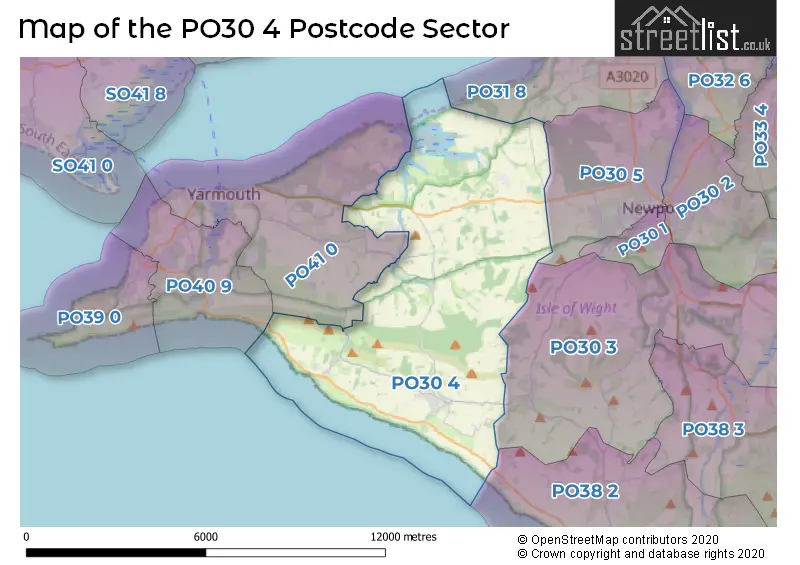
The PO30 4 Postcode shares a border with PO30 3 (NEWPORT, Shorwell, Arreton), PO30 5 (NEWPORT, Camp Hill), PO31 8 (COWES, Gurnard), PO38 2 (Niton, Whitwell, Chale Green), PO40 9 (FRESHWATER) and PO41 0 (YARMOUTH, Norton, Bouldnor).
The sector is within the post town of NEWPORT.
PO30 4 is a postcode sector within the PO3 postcode district which is within the PO Portsmouth postcode area.
The Royal Mail delivery office for the PO30 4 postal sector is the unknown.
The area of the PO30 4 postcode sector is 23.06 square miles which is 59.72 square kilometres or 14,755.97 square acres.
Waterways within the PO30 4 postcode sector include the Grange Chine, Chilton Chine.

Map of the PO30 4 Postcode Sector
Explore the PO30 4 postcode sector by using our free interactive map.
| P | O | 3 | 0 | - | 4 | X | X |
| P | O | 3 | 0 | Space | 4 | Letter | Letter |
Official List of Streets
Brighstone (38 Streets)
Brook (5 Streets)
NEWPORT (4 Streets)
Mottistone (3 Streets)
Shalfleet (12 Streets)
Porchfield (7 Streets)
Calbourne (17 Streets)
Ningwood (4 Streets)
Limerstone (2 Streets)
Newtown (4 Streets)
Rowridge (1 Streets)
Unofficial Streets or Alternative Spellings
Atherfield
MILITARY ROADNewbridge
CAULBOURNE LANE MAIN ROADHamstead
HAMSTEAD DRIVECranmore
NINGWOOD HILLSchools and Places of Education Within the PO30 4 Postcode Sector
Brighstone Church of England Aided Primary School
Voluntary aided school
New Road, Newport, Isle of Wight, PO30 4BB
Head: Mrs Rebecca Lennon
Ofsted Rating: Requires improvement
Inspection: 2021-11-25 (910 days ago)
Website: Visit Brighstone Church of England Aided Primary School Website
Phone: 01983740285
Number of Pupils: 86
Shalfleet Church of England Primary School
Voluntary controlled school
Station Road, Newport, Isle of Wight, PO30 4NN
Head: Mrs Elizabeth Grainger
Ofsted Rating: Good
Inspection: 2018-11-27 (2004 days ago)
Website: Visit Shalfleet Church of England Primary School Website
Phone: 01983760269
Number of Pupils: 191
House Prices in the PO30 4 Postcode Sector
| Type of Property | 2018 Average | 2018 Sales | 2017 Average | 2017 Sales | 2016 Average | 2016 Sales | 2015 Average | 2015 Sales |
|---|---|---|---|---|---|---|---|---|
| Detached | £351,461 | 38 | £370,549 | 42 | £358,833 | 66 | £325,521 | 48 |
| Semi-Detached | £296,681 | 8 | £228,500 | 6 | £253,469 | 16 | £274,682 | 11 |
| Terraced | £200,000 | 5 | £203,000 | 2 | £170,000 | 2 | £202,992 | 6 |
| Flats | £500,000 | 1 | £585,000 | 2 | £0 | 0 | £0 | 0 |
Important Postcodes PO30 4 in the Postcode Sector
PO30 4NN is the postcode for Shalfleet C of E Primary School, Station Road, Ningwood
| The PO30 4 Sector is within these Local Authorities |
|
|---|---|
| The PO30 4 Sector is within these Counties |
|
| The PO30 4 Sector is within these Water Company Areas |
|
Tourist Attractions within the PO30 4 Postcode Area
We found 2 visitor attractions within the PO3 postcode area
| Mottistone Manor Garden |
|---|
| Gardens |
| Garden |
| View Mottistone Manor Garden on Google Maps |
| Brighstone Village Museum |
| Museums & Art Galleries |
| Museum and / or Art Gallery |
| View Brighstone Village Museum on Google Maps |