The PO38 2 postcode sector is within the county of Isle of Wight.
Did you know? According to the 2021 Census, the PO38 2 postcode sector is home to a bustling 2,937 residents!
Given that each sector allows for 400 unique postcode combinations. Letters C, I, K, M, O and V are not allowed in the last two letters of a postcode. With 167 postcodes already in use, this leaves 233 units available.
The largest settlement in the PO38 2 postal code is Niton followed by Whitwell, and Chale Green.
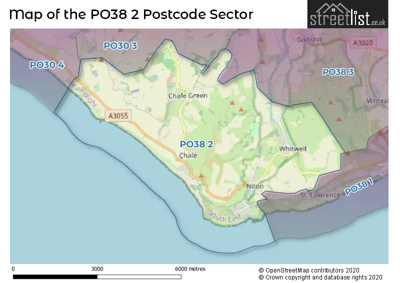
The PO38 2 Postcode shares a border with PO30 3 (NEWPORT, Shorwell, Arreton), PO30 4 (Brighstone, Shalfleet, Calbourne), PO38 1 (VENTNOR, St. Lawrence, Bonchurch) and PO38 3 (Wroxall, Godshill, Rookley).
The sector is within the post town of VENTNOR.
PO38 2 is a postcode sector within the PO3 postcode district which is within the PO Portsmouth postcode area.
The Royal Mail delivery office for the PO38 2 postal sector is the unknown.
The area of the PO38 2 postcode sector is 12.59 square miles which is 32.61 square kilometres or 8,058.20 square acres.
Waterways within the PO38 2 postcode sector include the Whale Chine, River Yar.

Map of the PO38 2 Postcode Sector
Explore the PO38 2 postcode sector by using our free interactive map.
| P | O | 3 | 8 | - | 2 | X | X |
| P | O | 3 | 8 | Space | 2 | Letter | Letter |
Official List of Streets
Whitwell (23 Streets)
Niton (27 Streets)
Chale Green (11 Streets)
Kingston (2 Streets)
Atherfield (3 Streets)
Chale (12 Streets)
Niton Undercliff (6 Streets)
VENTNOR (2 Streets)
Unofficial Streets or Alternative Spellings
Godshill
BEACON ALLEY WHITWELL ROADRookley
NITON ROADSt. Lawrence
UNDERCLIFF DRIVEShorwell
CHINE LANE DUNGEWOOD LANESchools and Places of Education Within the PO38 2 Postcode Sector
Niton Primary School
Community school
School Lane, Ventnor, Isle of Wight, PO38 2BP
Head: Mr Duncan Mills
Ofsted Rating: Good
Inspection: 2023-06-22 (348 days ago)
Website: Visit Niton Primary School Website
Phone: 01983730209
Number of Pupils: 204
House Prices in the PO38 2 Postcode Sector
| Type of Property | 2018 Average | 2018 Sales | 2017 Average | 2017 Sales | 2016 Average | 2016 Sales | 2015 Average | 2015 Sales |
|---|---|---|---|---|---|---|---|---|
| Detached | £395,000 | 26 | £323,887 | 27 | £330,589 | 31 | £291,744 | 29 |
| Semi-Detached | £273,009 | 22 | £255,154 | 13 | £255,725 | 20 | £213,759 | 23 |
| Terraced | £272,500 | 4 | £257,875 | 4 | £174,500 | 2 | £199,389 | 9 |
| Flats | £50,000 | 1 | £0 | 0 | £120,000 | 1 | £156,000 | 2 |
Important Postcodes PO38 2 in the Postcode Sector
PO38 2BP is the postcode for Niton Cp School, School Lane
| The PO38 2 Sector is within these Local Authorities |
|
|---|---|
| The PO38 2 Sector is within these Counties |
|
| The PO38 2 Sector is within these Water Company Areas |
|