The PO35 5 postcode sector is within the county of Isle of Wight.
Did you know? According to the 2021 Census, the PO35 5 postcode sector is home to a bustling 3,534 residents!
Given that each sector allows for 400 unique postcode combinations. Letters C, I, K, M, O and V are not allowed in the last two letters of a postcode. With 162 postcodes already in use, this leaves 238 units available.
The PO35 5 postal code covers the settlement of BEMBRIDGE.
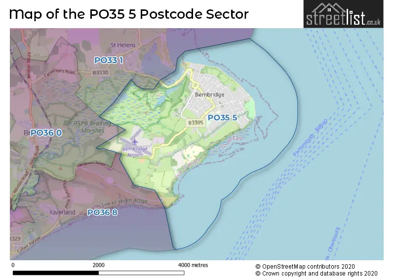
The PO35 5 Postcode shares a border with PO33 1 (RYDE, St. Helens, Oakfield), PO36 0 (Brading, Apse Heath, Newchurch) and PO36 8 (SANDOWN).
The sector is within the post town of BEMBRIDGE.
PO35 5 is a postcode sector within the PO35 postcode district which is within the PO Portsmouth postcode area.
The Royal Mail delivery office for the PO35 5 postal sector is the Ryde Delivery Office and Bembridge Scale Payment Delivery Office.
The area of the PO35 5 postcode sector is 2.55 square miles which is 6.60 square kilometres or 1,631.80 square acres.
Waterways within the PO35 5 postcode sector include the River Yar.

Map of the PO35 5 Postcode Sector
Explore the PO35 5 postcode sector by using our free interactive map.
| P | O | 3 | 5 | - | 5 | X | X |
| P | O | 3 | 5 | Space | 5 | Letter | Letter |
Official List of Streets
BEMBRIDGE (82 Streets)
Unofficial Streets or Alternative Spellings
Weather Forecast for PO35 5
Press Button to Show Forecast for Whitecliff Bay (Beach)
| Time Period | Icon | Description | Temperature | Rain Probability | Wind |
|---|---|---|---|---|---|
| 09:00 to 12:00 | Cloudy | 10.0°C (feels like 8.0°C) | 39.00% | ENE 11 mph | |
| 12:00 to 15:00 | Cloudy | 12.0°C (feels like 10.0°C) | 6.00% | E 11 mph | |
| 15:00 to 18:00 | Cloudy | 11.0°C (feels like 10.0°C) | 19.00% | E 9 mph | |
| 18:00 to 21:00 | Heavy rain | 11.0°C (feels like 9.0°C) | 88.00% | NE 11 mph | |
| 21:00 to 00:00 | Heavy rain | 10.0°C (feels like 7.0°C) | 87.00% | NE 13 mph |
Press Button to Show Forecast for Whitecliff Bay (Beach)
| Time Period | Icon | Description | Temperature | Rain Probability | Wind |
|---|---|---|---|---|---|
| 00:00 to 03:00 | Heavy rain | 10.0°C (feels like 7.0°C) | 90.00% | NE 13 mph | |
| 03:00 to 06:00 | Heavy rain | 9.0°C (feels like 7.0°C) | 93.00% | NE 11 mph | |
| 06:00 to 09:00 | Heavy rain | 8.0°C (feels like 5.0°C) | 89.00% | NNW 13 mph | |
| 09:00 to 12:00 | Heavy rain | 8.0°C (feels like 5.0°C) | 81.00% | NW 13 mph | |
| 12:00 to 15:00 | Overcast | 10.0°C (feels like 7.0°C) | 20.00% | WNW 13 mph | |
| 15:00 to 18:00 | Cloudy | 11.0°C (feels like 8.0°C) | 9.00% | W 13 mph | |
| 18:00 to 21:00 | Cloudy | 11.0°C (feels like 8.0°C) | 5.00% | WSW 11 mph | |
| 21:00 to 00:00 | Partly cloudy (night) | 9.0°C (feels like 7.0°C) | 2.00% | WSW 9 mph |
Press Button to Show Forecast for Whitecliff Bay (Beach)
| Time Period | Icon | Description | Temperature | Rain Probability | Wind |
|---|---|---|---|---|---|
| 00:00 to 03:00 | Clear night | 9.0°C (feels like 7.0°C) | 1.00% | WSW 9 mph | |
| 03:00 to 06:00 | Clear night | 8.0°C (feels like 6.0°C) | 1.00% | WSW 7 mph | |
| 06:00 to 09:00 | Sunny day | 9.0°C (feels like 8.0°C) | 1.00% | S 7 mph | |
| 09:00 to 12:00 | Partly cloudy (day) | 11.0°C (feels like 9.0°C) | 1.00% | S 11 mph | |
| 12:00 to 15:00 | Partly cloudy (day) | 12.0°C (feels like 10.0°C) | 1.00% | S 13 mph | |
| 15:00 to 18:00 | Sunny day | 12.0°C (feels like 10.0°C) | 1.00% | SSE 11 mph | |
| 18:00 to 21:00 | Sunny day | 12.0°C (feels like 10.0°C) | 1.00% | SE 9 mph | |
| 21:00 to 00:00 | Clear night | 11.0°C (feels like 9.0°C) | 2.00% | SE 11 mph |
Press Button to Show Forecast for Whitecliff Bay (Beach)
| Time Period | Icon | Description | Temperature | Rain Probability | Wind |
|---|---|---|---|---|---|
| 00:00 to 03:00 | Clear night | 11.0°C (feels like 9.0°C) | 1.00% | SE 13 mph | |
| 03:00 to 06:00 | Clear night | 11.0°C (feels like 9.0°C) | 2.00% | SE 11 mph | |
| 06:00 to 09:00 | Sunny day | 11.0°C (feels like 9.0°C) | 3.00% | SE 11 mph | |
| 09:00 to 12:00 | Sunny day | 12.0°C (feels like 10.0°C) | 5.00% | SE 13 mph | |
| 12:00 to 15:00 | Sunny day | 13.0°C (feels like 10.0°C) | 5.00% | SE 13 mph | |
| 15:00 to 18:00 | Sunny day | 13.0°C (feels like 10.0°C) | 5.00% | ESE 13 mph | |
| 18:00 to 21:00 | Cloudy | 13.0°C (feels like 11.0°C) | 10.00% | SE 11 mph | |
| 21:00 to 00:00 | Partly cloudy (night) | 12.0°C (feels like 10.0°C) | 5.00% | ESE 11 mph |
Schools and Places of Education Within the PO35 5 Postcode Sector
Bembridge Church of England Primary School
Voluntary controlled school
Walls Road, Bembridge, Isle of Wight, PO35 5RH
Head: Mrs Elizabeth Chambers
Ofsted Rating: Good
Inspection: 2019-12-18 (1592 days ago)
Website: Visit Bembridge Church of England Primary School Website
Phone: 01983872668
Number of Pupils: 195
House Prices in the PO35 5 Postcode Sector
| Type of Property | 2018 Average | 2018 Sales | 2017 Average | 2017 Sales | 2016 Average | 2016 Sales | 2015 Average | 2015 Sales |
|---|---|---|---|---|---|---|---|---|
| Detached | £445,048 | 60 | £420,069 | 62 | £430,330 | 50 | £393,970 | 56 |
| Semi-Detached | £298,125 | 16 | £293,352 | 24 | £262,091 | 11 | £288,831 | 18 |
| Terraced | £233,750 | 4 | £258,417 | 6 | £245,625 | 12 | £222,788 | 20 |
| Flats | £184,243 | 14 | £218,175 | 22 | £204,861 | 26 | £219,126 | 57 |
Important Postcodes PO35 5 in the Postcode Sector
PO35 5RH is the postcode for BEMBRIDGE CHURCH OF ENGLAND PRIMARY SCHOOL, WALLS ROAD, BEMBRIDGE, Bembridge Church Of England Primary School, Walls Road, and Bembridge C of E School, Walls Road
PO35 5UH is the postcode for Bembridge C of E Primary School, Steyne Road
| The PO35 5 Sector is within these Local Authorities |
|
|---|---|
| The PO35 5 Sector is within these Counties |
|
| The PO35 5 Sector is within these Water Company Areas |
|
Tourist Attractions within the PO35 5 Postcode Area
We found 1 visitor attractions within the PO35 postcode area
| Bembridge Windmill |
|---|
| Historic Properties |
| Other Historic Property |
| View Bembridge Windmill on Google Maps |