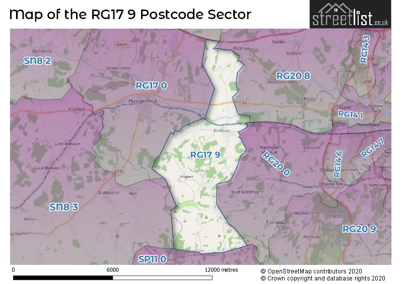
The RG17 9 postcode sector lies where the three counties of Berkshire, Hampshire, and Wiltshire meet.
Did you know? According to the 2021 Census, the RG17 9 postcode sector is home to a bustling 3,243 residents!
Given that each sector allows for 400 unique postcode combinations. Letters C, I, K, M, O and V are not allowed in the last two letters of a postcode. With 132 postcodes already in use, this leaves 268 units available.
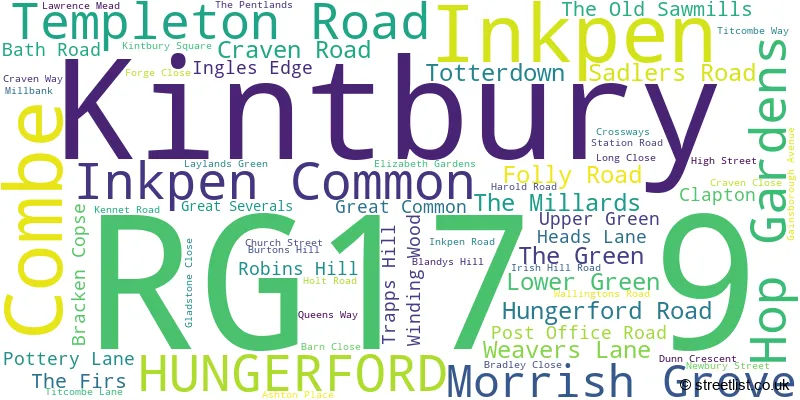
The largest settlement in the RG17 9 postal code is Kintbury followed by Inkpen, and Combe.
The RG17 9 Postcode shares a border with RG20 0 (Hamstead Marshall, Ball Hill, Enborne), RG17 0 (HUNGERFORD, Chilton Foliat, Eddington), RG17 7 (Great Shefford, Lambourn Woodlands, Lambourn), RG20 8 (Chieveley, Beedon, Stockcross), SN8 3 (Burbage, Great Bedwyn, Collingbourne Ducis) and SP11 0 (Weyhill, Hurstbourne Tarrant, Vernham Dean).
The sector is within the post town of HUNGERFORD.
RG17 9 is a postcode sector within the RG17 postcode district which is within the RG Reading postcode area.
The Royal Mail delivery office for the RG17 9 postal sector is the Hungerford Delivery Office.
The area of the RG17 9 postcode sector is 15.07 square miles which is 39.02 square kilometres or 9,641.75 square acres.
The RG17 9 postcode sector is crossed by the M4 motorway.
Waterways within the RG17 9 postcode sector include the Kennet & Avon Canal.

Map of the RG17 9 Postcode Sector
Explore the RG17 9 postcode sector by using our free interactive map.
| R | G | 1 | 7 | - | 9 | X | X |
| R | G | 1 | 7 | Space | 9 | Letter | Letter |
Official List of Streets
Kintbury (42 Streets)
Inkpen (18 Streets)
Inkpen Common (1 Streets)
Unofficial Streets or Alternative Spellings
HUNGERFORD
ANVILLESWeather Forecast for RG17 9
Press Button to Show Forecast for Hungerford
| Time Period | Icon | Description | Temperature | Rain Probability | Wind |
|---|---|---|---|---|---|
| 09:00 to 12:00 | Overcast | 6.0°C (feels like 3.0°C) | 18.00% | NE 11 mph | |
| 12:00 to 15:00 | Overcast | 8.0°C (feels like 6.0°C) | 14.00% | ENE 9 mph | |
| 15:00 to 18:00 | Cloudy | 10.0°C (feels like 8.0°C) | 13.00% | NE 11 mph | |
| 18:00 to 21:00 | Cloudy | 9.0°C (feels like 6.0°C) | 15.00% | NNE 11 mph | |
| 21:00 to 00:00 | Heavy rain | 7.0°C (feels like 4.0°C) | 82.00% | NNE 11 mph |
Press Button to Show Forecast for Hungerford
| Time Period | Icon | Description | Temperature | Rain Probability | Wind |
|---|---|---|---|---|---|
| 00:00 to 03:00 | Heavy rain | 7.0°C (feels like 3.0°C) | 87.00% | NNE 13 mph | |
| 03:00 to 06:00 | Heavy rain | 6.0°C (feels like 3.0°C) | 87.00% | N 13 mph | |
| 06:00 to 09:00 | Heavy rain | 6.0°C (feels like 2.0°C) | 89.00% | NNW 11 mph | |
| 09:00 to 12:00 | Heavy rain | 6.0°C (feels like 3.0°C) | 81.00% | NW 11 mph | |
| 12:00 to 15:00 | Light rain | 8.0°C (feels like 5.0°C) | 52.00% | WNW 11 mph | |
| 15:00 to 18:00 | Cloudy | 10.0°C (feels like 7.0°C) | 13.00% | WNW 9 mph | |
| 18:00 to 21:00 | Cloudy | 9.0°C (feels like 7.0°C) | 8.00% | WSW 7 mph | |
| 21:00 to 00:00 | Partly cloudy (night) | 6.0°C (feels like 4.0°C) | 3.00% | SW 7 mph |
Press Button to Show Forecast for Hungerford
| Time Period | Icon | Description | Temperature | Rain Probability | Wind |
|---|---|---|---|---|---|
| 00:00 to 03:00 | Clear night | 4.0°C (feels like 2.0°C) | 1.00% | SW 7 mph | |
| 03:00 to 06:00 | Clear night | 3.0°C (feels like 1.0°C) | 1.00% | SSW 4 mph | |
| 06:00 to 09:00 | Sunny day | 5.0°C (feels like 3.0°C) | 1.00% | S 7 mph | |
| 09:00 to 12:00 | Sunny day | 10.0°C (feels like 8.0°C) | 2.00% | S 11 mph | |
| 12:00 to 15:00 | Cloudy | 12.0°C (feels like 10.0°C) | 7.00% | S 13 mph | |
| 15:00 to 18:00 | Partly cloudy (day) | 13.0°C (feels like 10.0°C) | 3.00% | S 13 mph | |
| 18:00 to 21:00 | Sunny day | 11.0°C (feels like 9.0°C) | 3.00% | S 11 mph | |
| 21:00 to 00:00 | Clear night | 8.0°C (feels like 5.0°C) | 3.00% | SSE 9 mph |
Press Button to Show Forecast for Hungerford
| Time Period | Icon | Description | Temperature | Rain Probability | Wind |
|---|---|---|---|---|---|
| 00:00 to 03:00 | Clear night | 7.0°C (feels like 5.0°C) | 2.00% | SE 9 mph | |
| 03:00 to 06:00 | Clear night | 7.0°C (feels like 4.0°C) | 3.00% | SE 9 mph | |
| 06:00 to 09:00 | Sunny day | 8.0°C (feels like 6.0°C) | 5.00% | SE 9 mph | |
| 09:00 to 12:00 | Sunny day | 13.0°C (feels like 10.0°C) | 9.00% | SE 11 mph | |
| 12:00 to 15:00 | Sunny day | 15.0°C (feels like 12.0°C) | 10.00% | SE 13 mph | |
| 15:00 to 18:00 | Cloudy | 15.0°C (feels like 12.0°C) | 11.00% | SSE 11 mph | |
| 18:00 to 21:00 | Sunny day | 13.0°C (feels like 12.0°C) | 7.00% | SSE 9 mph | |
| 21:00 to 00:00 | Partly cloudy (night) | 10.0°C (feels like 9.0°C) | 6.00% | SE 7 mph |
Schools and Places of Education Within the RG17 9 Postcode Sector
Inkpen Primary School
Community school
Weavers Lane, Hungerford, Berkshire, RG17 9QE
Head: Miss Frances Buck
Ofsted Rating: Requires improvement
Inspection: 2023-06-22 (310 days ago)
Website: Visit Inkpen Primary School Website
Phone: 01488668219
Number of Pupils: 52
Kintbury St Mary's C.E. Primary School
Voluntary controlled school
Gainsborough Avenue, Hungerford, Berkshire, RG17 9XN
Head: Mrs Alison McDonald
Ofsted Rating: Good
Inspection: 2023-05-04 (359 days ago)
Website: Visit Kintbury St Mary's C.E. Primary School Website
Phone: 01488658336
Number of Pupils: 137
House Prices in the RG17 9 Postcode Sector
| Type of Property | 2018 Average | 2018 Sales | 2017 Average | 2017 Sales | 2016 Average | 2016 Sales | 2015 Average | 2015 Sales |
|---|---|---|---|---|---|---|---|---|
| Detached | £719,311 | 14 | £728,341 | 27 | £736,950 | 13 | £814,273 | 11 |
| Semi-Detached | £410,247 | 16 | £377,650 | 13 | £426,559 | 11 | £317,913 | 12 |
| Terraced | £339,300 | 8 | £255,850 | 10 | £329,968 | 11 | £262,173 | 17 |
| Flats | £468,520 | 10 | £545,143 | 10 | £516,624 | 37 | £424,920 | 5 |
Important Postcodes RG17 9 in the Postcode Sector
RG17 9TW is the postcode for Notrees Residential Care Home, 10 High Street
| The RG17 9 Sector is within these Local Authorities |
|
|---|---|
| The RG17 9 Sector is within these Counties |
|
| The RG17 9 Sector is within these Water Company Areas |
|