The RG5 postcode district is a postal district located in the RG Reading postcode area with a population of 27,826 residents according to the 2021 England and Wales Census.
The area of the RG5 postcode district is 3.11 square miles which is 8.07 square kilometres or 1,993.23 acres.
Currently, the RG5 district has about 502 postcode units spread across 2 geographic postcode sectors.
Given that each sector allows for 400 unique postcode combinations, the district has a capacity of 800 postcodes. With 502 postcodes already in use, this leaves 298 units available.
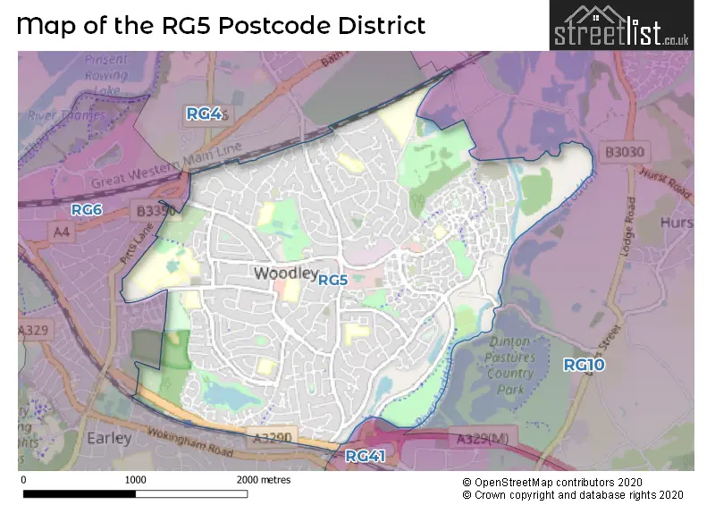
The RG5 postal code covers the settlement of Woodley.
The RG5 Postcode shares a border with RG10 (Twyford, Wargrave, Charvil), RG4 (Caversham, Emmer Green, Sonning Common), RG6 (Earley, Lower Earley, READING) and RG41 (WOKINGHAM, Winnersh, Sindlesham).
The primary settlement in the RG5 postcode district is Woodley, located in the county of Berkshire. Woodley is the most populous settlement within the district. The significant post town for the data is Reading, which is also located in Berkshire.
For the district RG5, we have data on 2 postcode sectors. Here's a breakdown: The sector RG5 3, covers Woodley in Berkshire. The sector RG5 4, covers Woodley in Berkshire.


Map of the RG5 Postcode District
Explore the RG5 postcode district by using our free interactive map.
When it comes to local government, postal geography often disregards political borders. However, for a breakdown in the RG5 District: the district mostly encompasses the Wokingham (B) area with a total of 503 postcodes.
Recent House Sales in RG5
| Date | Price | Address |
|---|---|---|
| 18/10/2023 | £500,000 | Lavenham Drive, Woodley, Reading, RG5 4PP |
| 11/10/2023 | £375,000 | Pitford Road, Woodley, Reading, RG5 4QF |
| 08/09/2023 | £490,000 | Blanchard Close, Woodley, Reading, RG5 4XQ |
| 05/09/2023 | £840,000 | Copse Mead, Woodley, Reading, RG5 4RP |
| 01/09/2023 | £500,000 | Malvern Close, Woodley, Reading, RG5 4HL |
| 01/09/2023 | £460,000 | Quentin Road, Woodley, Reading, RG5 3NE |
| 01/09/2023 | £300,000 | Ravensbourne Drive, Woodley, Reading, RG5 4LJ |
| 31/08/2023 | £408,000 | Cottesmore Road, Woodley, Reading, RG5 3NX |
| 31/08/2023 | £530,000 | Haddon Drive, Woodley, Reading, RG5 4LT |
| 29/08/2023 | £230,000 | Southlake Court, Woodley, Reading, RG5 3SQ |
Weather Forecast for RG5
Press Button to Show Forecast for Reading University
| Time Period | Icon | Description | Temperature | Rain Probability | Wind |
|---|---|---|---|---|---|
| 06:00 to 09:00 | Cloudy | 5.0°C (feels like 2.0°C) | 6.00% | ENE 7 mph | |
| 09:00 to 12:00 | Cloudy | 7.0°C (feels like 5.0°C) | 6.00% | ENE 9 mph | |
| 12:00 to 15:00 | Cloudy | 10.0°C (feels like 8.0°C) | 14.00% | ENE 7 mph | |
| 15:00 to 18:00 | Overcast | 10.0°C (feels like 9.0°C) | 16.00% | ENE 4 mph | |
| 18:00 to 21:00 | Cloudy | 10.0°C (feels like 8.0°C) | 14.00% | ENE 4 mph | |
| 21:00 to 00:00 | Cloudy | 7.0°C (feels like 4.0°C) | 13.00% | ENE 7 mph |
Press Button to Show Forecast for Reading University
| Time Period | Icon | Description | Temperature | Rain Probability | Wind |
|---|---|---|---|---|---|
| 00:00 to 03:00 | Cloudy | 5.0°C (feels like 3.0°C) | 12.00% | E 7 mph | |
| 03:00 to 06:00 | Light rain | 5.0°C (feels like 2.0°C) | 48.00% | ENE 7 mph | |
| 06:00 to 09:00 | Light rain | 5.0°C (feels like 3.0°C) | 51.00% | ENE 7 mph | |
| 09:00 to 12:00 | Overcast | 8.0°C (feels like 6.0°C) | 22.00% | ENE 9 mph | |
| 12:00 to 15:00 | Overcast | 11.0°C (feels like 9.0°C) | 19.00% | E 9 mph | |
| 15:00 to 18:00 | Overcast | 12.0°C (feels like 10.0°C) | 26.00% | ENE 11 mph | |
| 18:00 to 21:00 | Light rain | 10.0°C (feels like 8.0°C) | 53.00% | ENE 9 mph | |
| 21:00 to 00:00 | Light rain | 9.0°C (feels like 6.0°C) | 54.00% | NE 11 mph |
Press Button to Show Forecast for Reading University
| Time Period | Icon | Description | Temperature | Rain Probability | Wind |
|---|---|---|---|---|---|
| 00:00 to 03:00 | Heavy rain | 8.0°C (feels like 5.0°C) | 75.00% | NE 11 mph | |
| 03:00 to 06:00 | Heavy rain | 8.0°C (feels like 6.0°C) | 75.00% | NE 9 mph | |
| 06:00 to 09:00 | Light rain | 8.0°C (feels like 7.0°C) | 55.00% | ENE 4 mph | |
| 09:00 to 12:00 | Heavy rain shower (day) | 10.0°C (feels like 9.0°C) | 61.00% | E 7 mph | |
| 12:00 to 15:00 | Light rain shower (day) | 12.0°C (feels like 10.0°C) | 40.00% | SSW 9 mph | |
| 15:00 to 18:00 | Light rain shower (day) | 12.0°C (feels like 10.0°C) | 42.00% | W 11 mph | |
| 18:00 to 21:00 | Cloudy | 11.0°C (feels like 8.0°C) | 15.00% | W 9 mph | |
| 21:00 to 00:00 | Cloudy | 9.0°C (feels like 7.0°C) | 10.00% | W 7 mph |
Where is the RG5 Postcode District?
The postcode district for RG5 is located in the town of Reading. It is situated near various towns, including Wokingham to the South East (4.56 miles away), Henley-on-Thames to the North (5.75 miles away), Bracknell to the East (7.07 miles away), Maidenhead to the North East (8.05 miles away), and Yateley to the South (9.98 miles away). Additionally, RG5 is approximately 33.46 miles away from the center of London.
The district is within the post town of READING.
The sector has postcodes within the nation of England.
The RG5 Postcode District is in the Berkshire region of Berkshire, Buckinghamshire and Oxfordshire within the South East (England).
| Postcode Sector | Delivery Office |
|---|---|
| RG5 3 | East Reading Delivery Office |
| RG5 4 | East Reading Delivery Office |
| R | G | 5 | - | X | X | X |
| R | G | 5 | Space | Numeric | Letter | Letter |
Current Monthly Rental Prices
| # Bedrooms | Min Price | Max Price | Avg Price |
|---|---|---|---|
| 1 | £925 | £925 | £925 |
| 2 | £1,200 | £1,550 | £1,382 |
| 3 | £1,650 | £2,000 | £1,797 |
| 4 | £1,900 | £1,900 | £1,900 |
Current House Prices
| # Bedrooms | Min Price | Max Price | Avg Price |
|---|---|---|---|
| 1 | £130,000 | £325,000 | £208,800 |
| 2 | £225,000 | £600,000 | £367,893 |
| 3 | £365,000 | £785,000 | £472,813 |
| 4 | £435,000 | £940,000 | £631,169 |
| 5 | £519,400 | £1,050,000 | £748,960 |
Estate Agents who Operate in the RG5 District
| Logo | Name | Brand Name | Address | Contact Number | Total Properties |
|---|---|---|---|---|---|
 | Woodley | Parkers Estate Agents | 43 Crockhamwell Road Woodley Reading RG5 3JZ | 0118 969 3999 | 38 |
 | Reading | Whiteknights Estate Agents | Unit 5 Chalfont Court, Lower Earley District Centre, Lower Earley, RG6 5SY | 0118 230 0230 | 16 |
 | Reading | Woodleys Estate Agents | 132 Loddon Bridge Road, Woodley, RG5 4AW | 0118 230 2638 | 16 |
 | Woodley, Earley & Lower Earley | Davis Tate | 60a Headley Road, Woodley, Reading, RG5 4JE | 0118 969 3969 | 9 |
 | Woodley | Romans | 301 Loddon Bridge Road, Woodley, RG5 4BE | 0118 230 0943 | 7 |
| Type of Property | 2018 Average | 2018 Sales | 2017 Average | 2017 Sales | 2016 Average | 2016 Sales | 2015 Average | 2015 Sales |
|---|---|---|---|---|---|---|---|---|
| Detached | £547,322 | 83 | £510,007 | 104 | £513,634 | 111 | £473,705 | 155 |
| Semi-Detached | £397,801 | 155 | £396,491 | 182 | £378,499 | 158 | £352,257 | 184 |
| Terraced | £357,088 | 96 | £344,961 | 111 | £334,488 | 95 | £291,377 | 97 |
| Flats | £245,777 | 65 | £236,663 | 58 | £231,743 | 72 | £202,872 | 65 |