The RH16 1 postcode sector is within the county of West Sussex.
Did you know? According to the 2021 Census, the RH16 1 postcode sector is home to a bustling 7,613 residents!
Given that each sector allows for 400 unique postcode combinations. Letters C, I, K, M, O and V are not allowed in the last two letters of a postcode. With 224 postcodes already in use, this leaves 176 units available.
The largest settlements in the RH16 1 postal code are HAYWARDS HEATH and Lindfield.
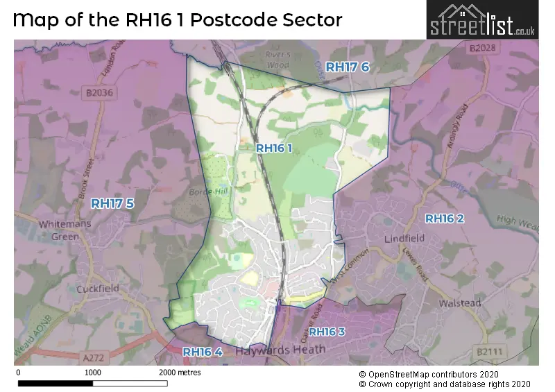
The RH16 1 Postcode shares a border with RH16 4 (HAYWARDS HEATH), RH16 2 (Lindfield, HAYWARDS HEATH), RH16 3 (HAYWARDS HEATH), RH17 5 (Cuckfield, Bolney, Warninglid) and RH17 6 (Balcombe, Ardingly, Handcross).
The sector is within the post town of HAYWARDS HEATH.
RH16 1 is a postcode sector within the RH1 postcode district which is within the RH Redhill postcode area.
The Royal Mail delivery office for the RH16 1 postal sector is the Redhill Delivery Office.
The area of the RH16 1 postcode sector is 2.81 square miles which is 7.28 square kilometres or 1,798.52 square acres.

Map of the RH16 1 Postcode Sector
Explore the RH16 1 postcode sector by using our free interactive map.
| R | H | 1 | 6 | - | 1 | X | X |
| R | H | 1 | 6 | Space | 1 | Letter | Letter |
Official List of Streets
HAYWARDS HEATH (76 Streets)
Unofficial Streets or Alternative Spellings
Ardingly
COLLEGE ROADLindfield
BY SUNTE SUNTE AVENUE WEST COMMON ASTER WAY BADER WAY BALCOME ROAD BARNARD GATE BLUEBIRD GROVE BORDEHILL LANE BRIDGERSMILL BULLNOSE CLOSE CAMPBELL MEAD CHAMPIONS PLACE CONISTON AVENUE COPYHOLD BRIDGE DOLPHIN ROAD GOLF CLUB DRIVE HEATHER BANK KINGS GATE LUCASTES MEWS MALLARD GARDENS MILL GREEN BUSINESS ESTATE NORRIS LANE OAKHURST LANE PARK VIEW PRINCESS COURT RIVERS ROAD SHEFFIELD MEWS SOUTH LODGE ROUNDABOUT TIMBERGATE DRIVE WINNALS PARKHAYWARDS HEATH
CALBOURNE MUSTER GREEN NORTH OATHALL ROAD QUEENS COURT THE ANCHORHOLDCuckfield
HANLYE LANEWeather Forecast for RH16 1
Press Button to Show Forecast for Borde Hill Garden
| Time Period | Icon | Description | Temperature | Rain Probability | Wind |
|---|---|---|---|---|---|
| 06:00 to 09:00 | Partly cloudy (day) | 7.0°C (feels like 7.0°C) | 4.00% | ESE 2 mph | |
| 09:00 to 12:00 | Partly cloudy (day) | 14.0°C (feels like 13.0°C) | 2.00% | SE 4 mph | |
| 12:00 to 15:00 | Cloudy | 16.0°C (feels like 14.0°C) | 6.00% | SSE 9 mph | |
| 15:00 to 18:00 | Cloudy | 15.0°C (feels like 13.0°C) | 6.00% | SSE 9 mph | |
| 18:00 to 21:00 | Cloudy | 13.0°C (feels like 12.0°C) | 9.00% | SSE 7 mph | |
| 21:00 to 00:00 | Cloudy | 11.0°C (feels like 11.0°C) | 14.00% | ESE 4 mph |
Press Button to Show Forecast for Borde Hill Garden
| Time Period | Icon | Description | Temperature | Rain Probability | Wind |
|---|---|---|---|---|---|
| 00:00 to 03:00 | Light rain | 11.0°C (feels like 10.0°C) | 49.00% | ENE 4 mph | |
| 03:00 to 06:00 | Light rain | 10.0°C (feels like 9.0°C) | 50.00% | NE 4 mph | |
| 06:00 to 09:00 | Cloudy | 11.0°C (feels like 10.0°C) | 49.00% | ENE 4 mph | |
| 09:00 to 12:00 | Light rain | 13.0°C (feels like 12.0°C) | 51.00% | E 7 mph | |
| 12:00 to 15:00 | Light rain | 14.0°C (feels like 13.0°C) | 51.00% | W 7 mph | |
| 15:00 to 18:00 | Light rain shower (day) | 15.0°C (feels like 14.0°C) | 40.00% | W 7 mph | |
| 18:00 to 21:00 | Cloudy | 14.0°C (feels like 13.0°C) | 15.00% | NNE 7 mph | |
| 21:00 to 00:00 | Cloudy | 11.0°C (feels like 10.0°C) | 8.00% | NE 4 mph |
Press Button to Show Forecast for Borde Hill Garden
| Time Period | Icon | Description | Temperature | Rain Probability | Wind |
|---|---|---|---|---|---|
| 00:00 to 03:00 | Cloudy | 10.0°C (feels like 9.0°C) | 6.00% | ENE 4 mph | |
| 03:00 to 06:00 | Partly cloudy (night) | 9.0°C (feels like 8.0°C) | 3.00% | NW 7 mph | |
| 06:00 to 09:00 | Sunny day | 11.0°C (feels like 9.0°C) | 3.00% | N 7 mph | |
| 09:00 to 12:00 | Sunny day | 14.0°C (feels like 13.0°C) | 2.00% | NNE 9 mph | |
| 12:00 to 15:00 | Partly cloudy (day) | 17.0°C (feels like 15.0°C) | 4.00% | NNE 9 mph | |
| 15:00 to 18:00 | Cloudy | 18.0°C (feels like 17.0°C) | 7.00% | NW 7 mph | |
| 18:00 to 21:00 | Partly cloudy (day) | 17.0°C (feels like 16.0°C) | 3.00% | NNE 7 mph | |
| 21:00 to 00:00 | Clear night | 12.0°C (feels like 12.0°C) | 2.00% | ENE 4 mph |
Press Button to Show Forecast for Borde Hill Garden
| Time Period | Icon | Description | Temperature | Rain Probability | Wind |
|---|---|---|---|---|---|
| 00:00 to 03:00 | Clear night | 10.0°C (feels like 9.0°C) | 1.00% | E 4 mph | |
| 03:00 to 06:00 | Clear night | 8.0°C (feels like 7.0°C) | 2.00% | NNE 4 mph | |
| 06:00 to 09:00 | Cloudy | 10.0°C (feels like 9.0°C) | 4.00% | NNE 4 mph | |
| 09:00 to 12:00 | Cloudy | 14.0°C (feels like 13.0°C) | 4.00% | NNE 4 mph | |
| 12:00 to 15:00 | Cloudy | 17.0°C (feels like 16.0°C) | 4.00% | N 4 mph | |
| 15:00 to 18:00 | Cloudy | 18.0°C (feels like 17.0°C) | 4.00% | N 4 mph | |
| 18:00 to 21:00 | Cloudy | 17.0°C (feels like 17.0°C) | 4.00% | NNW 4 mph | |
| 21:00 to 00:00 | Cloudy | 13.0°C (feels like 12.0°C) | 4.00% | SSE 4 mph |
Schools and Places of Education Within the RH16 1 Postcode Sector
Harlands Primary School
Academy converter
Penland Road, Haywards Heath, West Sussex, RH16 1PJ
Head: Mr David McKeown-Webster
Ofsted Rating: Good
Inspection: 2023-01-11 (480 days ago)
Website: Visit Harlands Primary School Website
Phone: 01444450782
Number of Pupils: 418
House Prices in the RH16 1 Postcode Sector
| Type of Property | 2018 Average | 2018 Sales | 2017 Average | 2017 Sales | 2016 Average | 2016 Sales | 2015 Average | 2015 Sales |
|---|---|---|---|---|---|---|---|---|
| Detached | £687,806 | 43 | £710,624 | 38 | £652,208 | 39 | £618,327 | 80 |
| Semi-Detached | £451,481 | 26 | £475,995 | 23 | £420,063 | 27 | £409,078 | 25 |
| Terraced | £371,083 | 12 | £334,204 | 12 | £344,039 | 14 | £356,477 | 17 |
| Flats | £258,750 | 50 | £239,301 | 97 | £233,284 | 61 | £220,263 | 67 |
Important Postcodes RH16 1 in the Postcode Sector
RH16 1AA is the postcode for Royal Mail, Haywards Heath Delivery Office, Mill Green Road
RH16 1BN is the postcode for SOCIAL SERVICES OFFICE OAKLANDS, Benefits Agency, Oaklands, 36 Boltro Road, and West Sussex County Council, Library, 34 Boltro Road
RH16 1BP is the postcode for Kingsley House, 31 Boltro Road
RH16 1LT is the postcode for Haywards Heath College, Harlands Road, NEW BUILDING, Central Sussex College Sixth Form, Harlands Road, MAIN BUILDING, Central Sussex College Sixth Form, Harlands Road, and Central Sussex College Sixth Form, Harlands Road
RH16 1LY is the postcode for The Dolphin, Pasture Hill Road
RH16 1PJ is the postcode for Harlands Primary School, Penland Road
RH16 1SS is the postcode for Mid Sussex District Council, Leisure and Sustainability Building, Mid Sussex District Council, Oaklands, Oaklands Road, and Mid Sussex District Council, Environment Building
RH16 1UD is the postcode for Nuffield Hospital, Burrell Road
RH16 1XQ is the postcode for Haywards Heath Fire & Ambulance Station, Mill Green Road, and West Sussex Fire & Rescue Service, Fire Station, Mill Green Road
| The RH16 1 Sector is within these Local Authorities |
|
|---|---|
| The RH16 1 Sector is within these Counties |
|
| The RH16 1 Sector is within these Water Company Areas |
|