The S60 1 postcode sector is within the county of South Yorkshire.
Did you know? According to the 2021 Census, the S60 1 postcode sector is home to a bustling 1,516 residents!
Given that each sector allows for 400 unique postcode combinations. Letters C, I, K, M, O and V are not allowed in the last two letters of a postcode. With 150 postcodes already in use, this leaves 250 units available.
The largest settlements in the S60 1 postal code are ROTHERHAM and Parkgate.
The S60 1 Postcode shares a border with S60 2 (ROTHERHAM), S61 1 (ROTHERHAM, Kimberworth), S62 6 (Parkgate, Rawmarsh), S9 1 (SHEFFIELD, Tinsley), S60 5 (Brinsworth, Treeton, Catcliffe), S61 4 (ROTHERHAM, Greasbrough), S65 1 (ROTHERHAM, Eastwood Trading Estate) and S65 3 (ROTHERHAM, Dalton).
The sector is within the post town of ROTHERHAM.
S60 1 is a postcode sector within the S6 postcode district which is within the S Sheffield postcode area.
The Royal Mail delivery office for the S60 1 postal sector is the Sheffield Npostal Delivery Office.
The area of the S60 1 postcode sector is 1.56 square miles which is 4.04 square kilometres or 998.19 square acres.
Waterways within the S60 1 postcode sector include the River Don, Sheffield and South Yorkshire Navigation, River Rother.

Map of the S60 1 Postcode Sector
Explore the S60 1 postcode sector by using our free interactive map.
| S | 6 | 0 | - | 1 | X | X |
| S | 6 | 0 | Space | 1 | Letter | Letter |
Official List of Streets
ROTHERHAM (80 Streets)
Unofficial Streets or Alternative Spellings
ROTHERHAM
ALMA ROAD ARMER STREET CANKLOW ROAD COKE HILL COKE LANE COLLEGE STREET DONCASTER GATE DRUMMOND STREET EFFINGHAM STREET MIDLAND ROAD MOORGATE STREET RODGER STREET SHIP HILL SNAIL HILL VICARAGE LANE WELLGATE WILFRED STREET AMEN CORNER ASPEN WAY BADEN STREET BRADMARSH BURRELL STREET CENTENARY WAY CENTURION STREET CHURCH STEPS CLAIRE COURT COGGIN MILL WAY COLLEGE ROAD ROUNDABOUT CORONATION BRIDGE CUPOLA YARD DEADMANS HOLE LANE DON STREET EKIN STREET FORGE LANE GARDEN LANE GEORGE STREET GRANGE LANE GREASEBROUGH ROAD HALL STREET HOPE STREET EXTENSION ICKLES ROUNDABOUT MARKET PLACE MARY STREET MILTON STREET NEVILLE STREET NEW WORTLEY ROAD PHOENIX ROAD ROTHERHAM BRIDGE SHEFFIELD ROAD;BRADMARSH;SHEFFIELD ROAD ST ANNS ROAD STONEROW WAY THE STATUTES WATER LANE WHEATHILL STREETTinsley
SHEFFIELD ROAD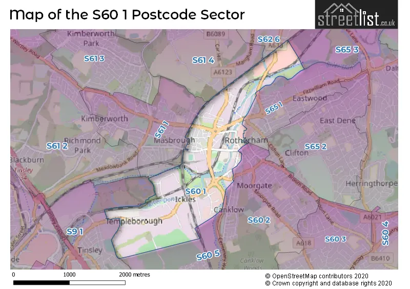
House Prices in the S60 1 Postcode Sector
| Type of Property | 2018 Average | 2018 Sales | 2017 Average | 2017 Sales | 2016 Average | 2016 Sales | 2015 Average | 2015 Sales |
|---|---|---|---|---|---|---|---|---|
| Detached | £126,400 | 1 | £0 | 0 | £0 | 0 | £0 | 0 |
| Semi-Detached | £0 | 0 | £0 | 0 | £60,000 | 1 | £0 | 0 |
| Terraced | £62,875 | 4 | £55,857 | 7 | £60,333 | 3 | £48,875 | 4 |
| Flats | £0 | 0 | £50,000 | 1 | £82,333 | 3 | £52,000 | 1 |
Important Postcodes S60 1 in the Postcode Sector
S60 1AA is the postcode for Royal Mail, Rotherham Delivery Office, Main Street
S60 1AE is the postcode for Rotherham Metropolitain Borough Council, Riverside House, Main Street, and ROTHERHAM METROPOLITAN BOROUGH COUNCIL, RIVERSIDE HOUSE, MAIN STREET
S60 1AJ is the postcode for South Yorkshire Probation Service, 12 Main Street
S60 1BY is the postcode for Environment Agency, Bow Bridge Close, Rotherham Metropolitan Borough Council, Reseby House, Bow Bridge Close, and Rotherham Metropolitan Borough Council, Reresby House, Bow Bridge Close
S60 1DX is the postcode for Parcelforce Worldwide, Magna Centre, Sheffield Road
S60 1HG is the postcode for Rotherham Metropolitan Borough Council, Orchard View, St. Bedes Road
S60 1QY is the postcode for South Yorkshire Police, Main Street
S60 1RU is the postcode for National Probation Service, Unit 2-3, Ashley Industrial Estate, Rawmarsh Road
S60 1RY is the postcode for Rotherham Community Health Centre, Greasbrough Road
S60 1TD is the postcode for Rotherham Metropolitan Borough Council, Bailey House, Rawmarsh Road
S60 1YW is the postcode for Rotherham Magistrates Court
| The S60 1 Sector is within these Local Authorities |
|
|---|---|
| The S60 1 Sector is within these Counties |
|
| The S60 1 Sector is within these Water Company Areas |
|