The S60 5 postcode sector is within the county of South Yorkshire.
Did you know? According to the 2021 Census, the S60 5 postcode sector is home to a bustling 15,219 residents!
Given that each sector allows for 400 unique postcode combinations. Letters C, I, K, M, O and V are not allowed in the last two letters of a postcode. With 270 postcodes already in use, this leaves 130 units available.
The largest settlement in the S60 5 postal code is Brinsworth followed by Treeton, and Catcliffe.
The S60 5 Postcode shares a border with S60 1 (ROTHERHAM, Parkgate), S60 2 (ROTHERHAM), S9 4 (SHEFFIELD), S26 3 (Aughton, Swallownest, Ulley), S9 1 (SHEFFIELD, Tinsley), S13 9 (SHEFFIELD, Handsworth, Woodhouse Mill) and S60 4 (Whiston, ROTHERHAM).
The sector is within the post town of ROTHERHAM.
S60 5 is a postcode sector within the S6 postcode district which is within the S Sheffield postcode area.
The Royal Mail delivery office for the S60 5 postal sector is the Sheffield Npostal Delivery Office.
The area of the S60 5 postcode sector is 4.27 square miles which is 11.05 square kilometres or 2,731.05 square acres.
The S60 5 postcode sector is crossed by the M1 motorway.
Waterways within the S60 5 postcode sector include the River Rother.

Map of the S60 5 Postcode Sector
Explore the S60 5 postcode sector by using our free interactive map.
| S | 6 | 0 | - | 5 | X | X |
| S | 6 | 0 | Space | 5 | Letter | Letter |
Official List of Streets
Treeton (54 Streets)
Brinsworth (121 Streets)
Catcliffe (48 Streets)
Unofficial Streets or Alternative Spellings
Aughton
TREETON LANE ARMISTEAD WAY ARUNDEL COTTAGES ASHOVER CROFT ASKHAM WAY AUTUMN FIELDS BALK LANE BAMFORD WALK BASLOW PLACE BRADFIELD WAY BROOMHILL AVENUE CATCLIFFE ROUNDABOUT CENTENARY WAY CHAPEL WALK CHERRY WOOD WAY CRESSBROOK ROAD CRESWELL DRIVE EYAM WAY FREDRICK STREET GREEN FINCH CLOSE GREEN LANE HARLINGTON WAY HASSOP COURT HAWES WAY HAWORTH LANE HIGH HAZEL ROAD HIGHFIELD DRIVE HIGHFIELD SPRING HOLMESFIELD GROVE LESCAR ROAD LETWELL WAY LONG LANE MATLOCK WAY MAYFIELD DRIVE MITCHELL WAY OWLTHORPE LANE PARKSIDE WAY PEAK DALE DRIVE PETT WALK QUARRY ROAD ROTHERFIELDS ROTHERHAM GATEWAY ROTHERHAM ROUNDWALK ROTHERWAY ROWSLEY DRIVE SORBY ROW SPRINGFIELDS STEPHENSON WAY THE BUNGALOWS THE CRESCENT THE TWENTY LANDS TIDESWELL WALK TREETON LANE TREETON NO 10 TREETON NO 11 TREETON NO 19 TREETON NO 9 WAVERLEY WALK WENSLEY ROAD WOODHOUSE DRIVE WOODHOUSE VIEW WOODLANDS FARMSHEFFIELD
EUROPA LINK HIGHFIELD LANEROTHERHAM
CANKLOW ROAD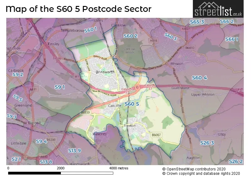
House Prices in the S60 5 Postcode Sector
| Type of Property | 2018 Average | 2018 Sales | 2017 Average | 2017 Sales | 2016 Average | 2016 Sales | 2015 Average | 2015 Sales |
|---|---|---|---|---|---|---|---|---|
| Detached | £215,391 | 47 | £218,733 | 44 | £181,491 | 42 | £195,470 | 54 |
| Semi-Detached | £128,448 | 125 | £125,830 | 124 | £119,730 | 118 | £117,251 | 127 |
| Terraced | £100,870 | 47 | £94,159 | 46 | £116,390 | 43 | £113,534 | 37 |
| Flats | £91,688 | 4 | £84,429 | 7 | £94,250 | 12 | £93,399 | 5 |
Important Postcodes S60 5 in the Postcode Sector
S60 5BL is the postcode for AMRC Training Centre, Advanced Manufacturing Park
S60 5BX is the postcode for Brinsworth Manor Junior School, Brinsworth Lane, Brinsworth Manor Infants School, Brinsworth Lane, BRINSWORTH MANOR JUNIOR SCHOOL, BRINSWORTH LANE, BRINSWORTH, Brinsworth Manor J&I School, Brinsworth Lane, BRINSWORTH MANOR INFANT SCHOOL, BRINSWORTH LANE, BRINSWORTH, Howarth House, Brinsworth Lane, and MAIN BUILDING, Brinsworth Manor J&I School, Brinsworth Lane
S60 5EJ is the postcode for BLOCK S, Brinsworth Comprehensive School Academy Trust, Brinsworth Road, Brinsworth Academy (Part of LEAP MAT (co. 07361021), Brinsworth Road, IAN BURTON SPORTS CENTRE, Brinsworth Academy (Part of LEAP MAT (co. 07361021), Brinsworth Road, BLOCK C, Brinsworth Academy (Part of LEAP MAT (co. 07361021), Brinsworth Road, BLOCK E/F, Brinsworth Academy (Part of LEAP MAT (co. 07361021), Brinsworth Road, BLOCK J, Brinsworth Academy (Part of LEAP MAT (co. 07361021), Brinsworth Road, IAN BURTON SPORTS CENTRE, Brinsworth Comprehensive School Academy Trust, Brinsworth Road, BLOCK J, Brinsworth Comprehensive School Academy Trust, Brinsworth Road, BLOCK A, Brinsworth Academy (Part of LEAP MAT (co. 07361021), Brinsworth Road, SPORTS HALL, Brinsworth Academy (Part of LEAP MAT (co. 07361021), Brinsworth Road, BLOCK E/F, Brinsworth Comprehensive School Academy Trust, Brinsworth Road, Block G, Brinsworth Comprehensive School Academy Trust, Brinsworth Road, BLOCK D, Brinsworth Academy (Part of LEAP MAT (co. 07361021), Brinsworth Road, BLOCK G, Brinsworth Academy (Part of LEAP MAT (co. 07361021), Brinsworth Road, BLOCK C, Brinsworth Comprehensive School Academy Trust, Brinsworth Road, and BLOCK S, Brinsworth Academy (Part of LEAP MAT (co. 07361021), Brinsworth Road
S60 5HT is the postcode for Brinsworth Whitehill Primary School, Howlett Drive, Brinsworth Whitehill Primary School, Howlett Drive, Brinsworth, and Brinsworth Whitehill J M School, Howlett Drive
S60 5JR is the postcode for Howarth Junior & Infant School, Whitehill Lane, Brinsworth, and Howarth Junior & Infant School, Whitehill Lane
S60 5ND is the postcode for Brinsworth Medical Centre, 171 Bawtry Road
S60 5QS is the postcode for MAIN BUILDING, Treeton C of E Junior & Infant School, Wood Lane, and Treeton C of E Junior & Infant School, Wood Lane
S60 5SW is the postcode for Catcliffe Primary School, Rotherham Road, Catcliffe, KEY STAGE 2 BUILDING, Catcliffe Primary School, Rotherham Road, and Catcliffe Primary School, Rotherham Road
S60 5TR is the postcode for Boundary Mill Stores, Poplar Way, Kieran Wilshaw, Poplar Way, Catcliffe, and Foers Unit C1, Poplar Way, Catcliffe
S60 5TZ is the postcode for Foers Unit C2, Poplar Way, Catcliffe, Advanced Manufacturing Research Centre, Wallis Way, WAVERLEY, AMRC DPTC, Wallis Way, and AMRC DPTC, Wallis Way
S60 5WG is the postcode for AMRC CTI2, University of Sheffield, Brunel Way, AMRC CTI1, University of Sheffield, Brunel Way, Knowledge Transfer Centre, Brunel Way, Nuclear Advanced Manufacturing Centre, Brunel Way, WAVERLEY 1, University of Sheffield, Brunel Way, and AMRC 4 (KTC) KNOWLEDGE TRANSFER CENTRE, Nuclear Advanced Manufacturing Centre & Knowledge Transfer Centre, Brunel Way
| The S60 5 Sector is within these Local Authorities |
|
|---|---|
| The S60 5 Sector is within these Counties |
|
| The S60 5 Sector is within these Water Company Areas |
|