The S61 1 postcode sector is within the county of South Yorkshire.
Did you know? According to the 2021 Census, the S61 1 postcode sector is home to a bustling 7,106 residents!
Given that each sector allows for 400 unique postcode combinations. Letters C, I, K, M, O and V are not allowed in the last two letters of a postcode. With 173 postcodes already in use, this leaves 227 units available.
The largest settlements in the S61 1 postal code are ROTHERHAM and Kimberworth.
The S61 1 Postcode shares a border with S60 1 (ROTHERHAM, Parkgate), S61 3 (ROTHERHAM, Kimberworth), S9 1 (SHEFFIELD, Tinsley), S61 2 (ROTHERHAM, Thorpe Hesley, Scholes) and S61 4 (ROTHERHAM, Greasbrough).
The sector is within the post town of ROTHERHAM.
S61 1 is a postcode sector within the S6 postcode district which is within the S Sheffield postcode area.
The Royal Mail delivery office for the S61 1 postal sector is the Sheffield Npostal Delivery Office.
The area of the S61 1 postcode sector is 0.82 square miles which is 2.13 square kilometres or 525.59 square acres.
Waterways within the S61 1 postcode sector include the River Don.

Map of the S61 1 Postcode Sector
Explore the S61 1 postcode sector by using our free interactive map.
| S | 6 | 1 | - | 1 | X | X |
| S | 6 | 1 | Space | 1 | Letter | Letter |
Official List of Streets
ROTHERHAM (79 Streets)
Unofficial Streets or Alternative Spellings
ROTHERHAM
CAINE GARDENS CLAREMONT STREET COLLEGE ROAD EILAM CLOSE MASBROUGH STREET MEADOW BANK ROAD PITT STREET PRINCES STREET WARREN HILL CLOUGH BANK CORONATION BRIDGE GARDEN STREET GREAVES ROAD HARTLEY LANE HENLEY LANE LOW LANE MEADOWBANK ROAD NEW WORTLEY ROAD POTTERY ROAD QUARRY LANE RHYMERS ROUNDABOUT WILTON GARDENS WILTON LANEKimberworth
HIGH STREETROTHERHAM,
MEADOWHALL ROADGreasbrough
FENTON ROAD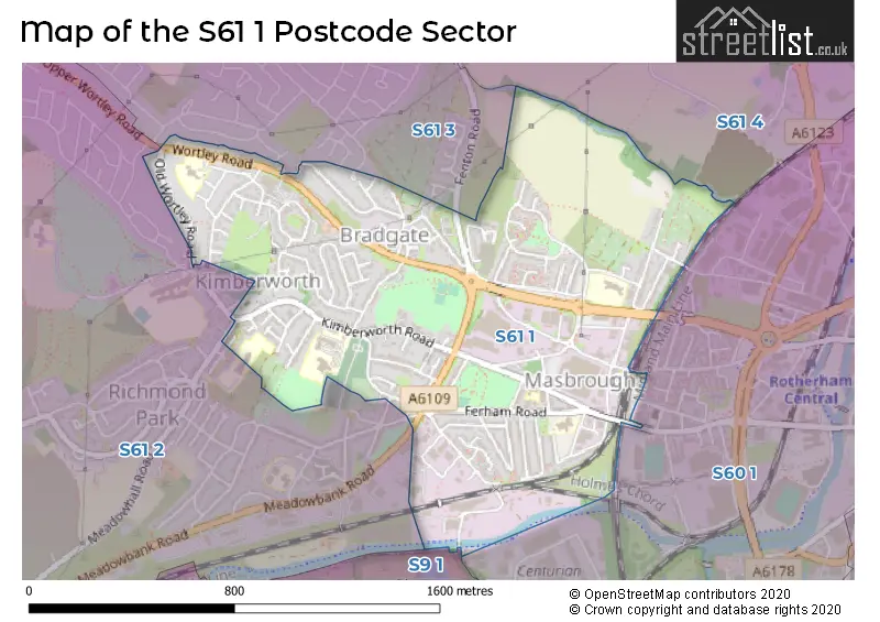
House Prices in the S61 1 Postcode Sector
| Type of Property | 2018 Average | 2018 Sales | 2017 Average | 2017 Sales | 2016 Average | 2016 Sales | 2015 Average | 2015 Sales |
|---|---|---|---|---|---|---|---|---|
| Detached | £168,250 | 20 | £145,617 | 6 | £136,845 | 10 | £161,438 | 8 |
| Semi-Detached | £126,697 | 30 | £130,624 | 43 | £122,445 | 33 | £112,607 | 28 |
| Terraced | £58,210 | 43 | £57,142 | 42 | £59,486 | 36 | £61,161 | 37 |
| Flats | £97,250 | 4 | £75,550 | 10 | £75,613 | 4 | £81,300 | 5 |
Important Postcodes S61 1 in the Postcode Sector
S61 1AH is the postcode for Woodstock Bower Group Practice, Kimberworth Road
S61 1AJ is the postcode for Rotherham Mental Health Care, Ferham House, Kimberworth Road
S61 1AP is the postcode for Ferham Primary School, Ferham Road
S61 1HE is the postcode for Kimberworth Place, Kimberworth Road, Bradgate, Rotherham Borough Council, Psalter's Lane Centre, Kimberworth Community Primary School & Childrens Centre, Kimberworth Road, and Rotherham Borough Council, Kimberworth Place, Kimberworth Road
S61 1PD is the postcode for St. Bedes Primary School, Wortley Road, and MAIN BUILDING, St. Bedes Primary School, Wortley Road
S61 1TD is the postcode for Thornhill Primary School, Clough Bank, Masbrough, Thornhill Primary School, Henley Rise, and Thornhill Primary School, Clough Bank, Thornhill
| The S61 1 Sector is within these Local Authorities |
|
|---|---|
| The S61 1 Sector is within these Counties |
|
| The S61 1 Sector is within these Water Company Areas |
|