The S63 8 postcode sector is within the county of South Yorkshire.
Did you know? According to the 2021 Census, the S63 8 postcode sector is home to a bustling 7,569 residents!
Given that each sector allows for 400 unique postcode combinations. Letters C, I, K, M, O and V are not allowed in the last two letters of a postcode. With 178 postcodes already in use, this leaves 222 units available.
The S63 8 postal code covers the settlement of Bolton-upon-Dearne.
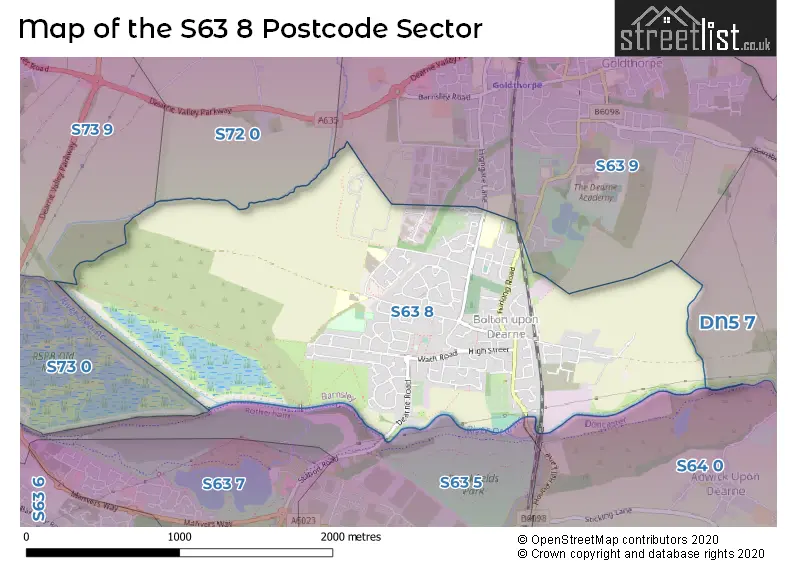
The S63 8 Postcode shares a border with S73 0 (Wombwell, Brampton, Hemingfield), S73 9 (Darfield), S63 5 (Manvers), S63 9 (Goldthorpe), S64 0 (MEXBOROUGH, Adwick-upon-Dearne), S72 0 (Great Houghton, Little Houghton, Billingley) and DN5 7 (Sprotbrough, Barnburgh, Scawthorpe).
The sector is within the post town of ROTHERHAM.
S63 8 is a postcode sector within the S6 postcode district which is within the S Sheffield postcode area.
The Royal Mail delivery office for the S63 8 postal sector is the unknown.
The area of the S63 8 postcode sector is 1.82 square miles which is 4.71 square kilometres or 1,164.28 square acres.
Waterways within the S63 8 postcode sector include the River Dearne.

Map of the S63 8 Postcode Sector
Explore the S63 8 postcode sector by using our free interactive map.
| S | 6 | 3 | - | 8 | X | X |
| S | 6 | 3 | Space | 8 | Letter | Letter |
Official List of Streets
Bolton-upon-Dearne (108 Streets)
Unofficial Streets or Alternative Spellings
House Prices in the S63 8 Postcode Sector
| Type of Property | 2018 Average | 2018 Sales | 2017 Average | 2017 Sales | 2016 Average | 2016 Sales | 2015 Average | 2015 Sales |
|---|---|---|---|---|---|---|---|---|
| Detached | £185,601 | 24 | £167,856 | 27 | £156,185 | 35 | £163,564 | 17 |
| Semi-Detached | £99,955 | 65 | £95,225 | 68 | £92,213 | 69 | £83,425 | 46 |
| Terraced | £74,727 | 48 | £74,493 | 37 | £73,994 | 33 | £70,853 | 29 |
| Flats | £0 | 0 | £53,500 | 2 | £37,000 | 1 | £52,500 | 1 |
Important Postcodes S63 8 in the Postcode Sector
S63 8AL is the postcode for DEARNE CARRFIELD PRIMARY ACADEMY, HIGHGATE LANE, GOLDTHORPE, Carrfield Primary Academy, Highgate Lane, Goldthorpe, and Carrfield Junior & Infant School, Highgate Lane
S63 8DA is the postcode for Lacewood Primary School, Carr Head Lane
S63 8ES is the postcode for Dearne Community Childrens Centre, Billingley View
| The S63 8 Sector is within these Local Authorities |
|
|---|---|
| The S63 8 Sector is within these Counties |
|
| The S63 8 Sector is within these Water Company Areas |
|