The S66 8 postcode sector is within the county of South Yorkshire.
Did you know? According to the 2021 Census, the S66 8 postcode sector is home to a bustling 9,227 residents!
Given that each sector allows for 400 unique postcode combinations. Letters C, I, K, M, O and V are not allowed in the last two letters of a postcode. With 228 postcodes already in use, this leaves 172 units available.
The largest settlement in the S66 8 postal code is Maltby followed by Hellaby, and Hooton Levitt.
The S66 8 Postcode shares a border with S66 1 (Wickersley, Bramley), S66 2 (Wickersley, Bramley, Flanderwell), S25 1 (Laughton), DN11 9 (Tickhill, Wadworth, Loversall), S66 7 (Maltby, Braithwell, Stainton), S66 9 (Thurcroft, Brampton-en-le-Morthen, Morthen), S65 4 (Thrybergh, Ravenfield, Dalton) and S81 8 (Shireoaks, Gateford, Blyth).
The sector is within the post town of ROTHERHAM.
S66 8 is a postcode sector within the S6 postcode district which is within the S Sheffield postcode area.
The Royal Mail delivery office for the S66 8 postal sector is the unknown.
The area of the S66 8 postcode sector is 7.91 square miles which is 20.48 square kilometres or 5,060.73 square acres.
The S66 8 postcode sector is crossed by the M18 motorway.
Waterways within the S66 8 postcode sector include the River Torne, Maltby Dike.

Map of the S66 8 Postcode Sector
Explore the S66 8 postcode sector by using our free interactive map.
| S | 6 | 6 | - | 8 | X | X |
| S | 6 | 6 | Space | 8 | Letter | Letter |
Official List of Streets
Maltby (144 Streets)
Hellaby (24 Streets)
Hooton Levitt (5 Streets)
Unofficial Streets or Alternative Spellings
Maltby
CARLYLE ROAD CHURCHILL AVENUE MANOR ROAD MEADOW LANE MILLICENT SQUARE MILLINDALE QUEEN AVENUE QUEEN MARY STREET TICKHILL ROAD VICTORIA STREETTickhill
SANDBECK LANELaughton
ABBEY LANE BIB LANE EAST FIELD LANEBramley
BAWTRY ROADStainton
SCOTCH SPRING LANE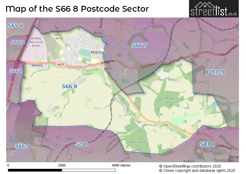
House Prices in the S66 8 Postcode Sector
| Type of Property | 2018 Average | 2018 Sales | 2017 Average | 2017 Sales | 2016 Average | 2016 Sales | 2015 Average | 2015 Sales |
|---|---|---|---|---|---|---|---|---|
| Detached | £193,952 | 44 | £202,618 | 65 | £183,598 | 49 | £166,321 | 57 |
| Semi-Detached | £127,931 | 75 | £120,601 | 86 | £122,233 | 58 | £112,353 | 58 |
| Terraced | £91,979 | 12 | £106,156 | 8 | £86,571 | 7 | £80,938 | 8 |
| Flats | £0 | 0 | £50,000 | 1 | £0 | 0 | £61,000 | 1 |
Important Postcodes S66 8 in the Postcode Sector
S66 8AB is the postcode for BLOCK 6, Maltby Academy, Braithwell Road, BLOCK 2, Maltby Academy, Braithwell Road, BLOCK 5, Maltby Academy, Braithwell Road, MAIN BUILDING, Maltby Academy, Braithwell Road, BLOCK 3, Maltby Academy, Braithwell Road, BLOCK 1&7, Maltby Academy, Braithwell Road, Maltby Comprehensive School, Braithwell Road, and BLOCK 4, Maltby Academy, Braithwell Road
S66 8AU is the postcode for INFANTS BLOCK, Lilly Hall Primary School, Cliff Hill, JUNIORS BLOCK, Lilly Hall Primary School, Cliff Hill, and Lilly Hall Primary School, Cliff Hill
S66 8AZ is the postcode for Hilltop Special School, Larch Road, Maltby, and Hilltop Special School, Larch Road
S66 8BE is the postcode for Linx Youth & Community Centre, Lilly Hall Road
S66 8DG is the postcode for MAIN BUILDING, Addison Day Centre, Addison Road, CRAFT BLOCK, Addison Day Centre, Addison Road, and Addison Day Centre, Addison Road
S66 8DL is the postcode for Maltby Redwood Jmi School, Redwood Drive, Maltby, Maltby Redwood Academy, Redwood Drive, and Maltby Redwood Jmi School, Redwood Drive
S66 8ER is the postcode for South Yorkshire Police, Maltby Police Station, Byford Road, Maltby Police Station, Byford Road, and South Yorkshire Police, Maltby Police Station, Byford Road, Maltby
S66 8JD is the postcode for Blyth Road Medical Centre, 8 Blyth Road
S66 8JE is the postcode for Places for People Leisure Management Ltd, Maltby Leisure Centre, High Street, Maltby Leisure Centre, High Street, and Maltby Sports Centre, Braithwell Road
S66 8JN is the postcode for Infants Building, Maltby Manor Primary School, Davy Drive, JUNIOR, Maltby Manor Primary School, Davy Drive, and INFANT, Maltby Manor Primary School, Davy Drive
S66 8LB is the postcode for South Yorkshire Police, Unit 3, Kea Park Close, Hellaby, and South Yorkshire Police, Unit 3, Kea Park Close
S66 8LD is the postcode for Rotherham Metropolitan Borough Council, Maltby Library, High Street
S66 8QL is the postcode for SANDBECK BUILDING, Rotherham Metropolitan Borough Council, Sandbeck Way
| The S66 8 Sector is within these Local Authorities |
|
|---|---|
| The S66 8 Sector is within these Counties |
|
| The S66 8 Sector is within these Water Company Areas |
|
Tourist Attractions within the S66 8 Postcode Area
We found 1 visitor attractions within the S6 postcode area
| Roche Abbey |
|---|
| Historic Properties |
| Historic Monument / Archaeological Site |
| View Roche Abbey on Google Maps |