The S66 9 postcode sector is within the county of South Yorkshire.
Did you know? According to the 2021 Census, the S66 9 postcode sector is home to a bustling 6,360 residents!
Given that each sector allows for 400 unique postcode combinations. Letters C, I, K, M, O and V are not allowed in the last two letters of a postcode. With 189 postcodes already in use, this leaves 211 units available.
The largest settlement in the S66 9 postal code is Thurcroft followed by Brampton-en-le-Morthen, and Morthen.
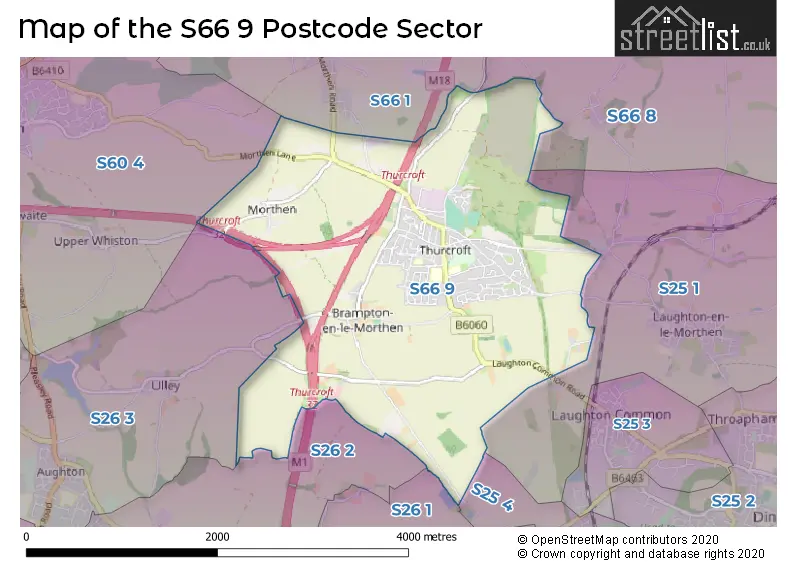
The S66 9 Postcode shares a border with S66 1 (Wickersley, Bramley), S25 1 (Laughton), S25 4 (North Anston), S26 1 (Todwick), S26 2 (Aston), S26 3 (Aughton, Swallownest, Ulley), S66 8 (Maltby, Hellaby, Hooton Levitt) and S60 4 (Whiston, ROTHERHAM).
The sector is within the post town of ROTHERHAM.
S66 9 is a postcode sector within the S6 postcode district which is within the S Sheffield postcode area.
The Royal Mail delivery office for the S66 9 postal sector is the unknown.
The area of the S66 9 postcode sector is 4.17 square miles which is 10.80 square kilometres or 2,669.82 square acres.
The S66 9 postcode sector is crossed by the M1 motorway.
The S66 9 postcode sector is crossed by the M18 motorway.

Map of the S66 9 Postcode Sector
Explore the S66 9 postcode sector by using our free interactive map.
| S | 6 | 6 | - | 9 | X | X |
| S | 6 | 6 | Space | 9 | Letter | Letter |
Official List of Streets
Thurcroft (95 Streets)
Brampton-en-le-Morthen (3 Streets)
Morthen (2 Streets)
Unofficial Streets or Alternative Spellings
Schools and Places of Education Within the S66 9 Postcode Sector
Thurcroft Junior Academy
Academy sponsor led
Green Arbour Road, Rotherham, , S66 9DD
Head: Mrs Ruth Stone
Ofsted Rating: Good
Inspection: 2018-07-03 (2160 days ago)
Website: Visit Thurcroft Junior Academy Website
Phone: 01709543194
Number of Pupils: 275
House Prices in the S66 9 Postcode Sector
| Type of Property | 2018 Average | 2018 Sales | 2017 Average | 2017 Sales | 2016 Average | 2016 Sales | 2015 Average | 2015 Sales |
|---|---|---|---|---|---|---|---|---|
| Detached | £179,905 | 21 | £197,379 | 63 | £209,799 | 68 | £202,358 | 54 |
| Semi-Detached | £110,980 | 35 | £129,168 | 52 | £105,871 | 64 | £97,579 | 65 |
| Terraced | £94,885 | 24 | £85,334 | 25 | £94,737 | 38 | £87,328 | 35 |
| Flats | £47,000 | 1 | £47,000 | 2 | £50,000 | 2 | £0 | 0 |
Important Postcodes S66 9 in the Postcode Sector
S66 9DD is the postcode for Thurcroft Junior Academy, Green Arbour Road, Thurcroft, Thurcroft Junior Academy, Green Arbour Road, and Thurcroft Junior School, Green Arbour Road, Thurcroft
S66 9LY is the postcode for Copeland Lodge, Green Arbour Road
S66 9NT is the postcode for The Willows School, Locksley Drive, PLAYGROUP BUILDING, Thurcroft Infant School, Locksley Drive, The Willows School, Locksley Drive, Thurcroft, Thurcroft Infant School, Locksley Drive, and MAIN BUILDING, Thurcroft Infant School, Locksley Drive
| The S66 9 Sector is within these Local Authorities |
|
|---|---|
| The S66 9 Sector is within these Counties |
|
| The S66 9 Sector is within these Water Company Areas |
|