The S75 1 postcode sector is within the county of South Yorkshire.
Did you know? According to the 2021 Census, the S75 1 postcode sector is home to a bustling 7,792 residents!
Given that each sector allows for 400 unique postcode combinations. Letters C, I, K, M, O and V are not allowed in the last two letters of a postcode. With 197 postcodes already in use, this leaves 203 units available.
The largest settlement in the S75 1 postal code is BARNSLEY followed by Barugh Green, and Higham.
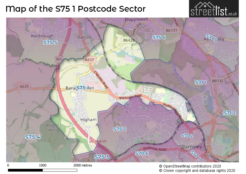
The S75 1 Postcode shares a border with S75 2 (BARNSLEY, Gawber), S75 6 (Mapplewell, Staincross), S70 2 (BARNSLEY), S71 1 (BARNSLEY), S75 3 (Dodworth, Tankersley, Hood Green), S75 4 (Silkstone, Cawthorne, Silkstone Common) and S75 5 (Darton, Woolley Grange, Staincross).
The sector is within the post town of BARNSLEY.
S75 1 is a postcode sector within the S7 postcode district which is within the S Sheffield postcode area.
The Royal Mail delivery office for the S75 1 postal sector is the Sheffield Scale Payment Delivery Office.
The area of the S75 1 postcode sector is 2.52 square miles which is 6.52 square kilometres or 1,610.60 square acres.
The S75 1 postcode sector is crossed by the M1 motorway.
Waterways within the S75 1 postcode sector include the River Dearne.

Map of the S75 1 Postcode Sector
Explore the S75 1 postcode sector by using our free interactive map.
| S | 7 | 5 | - | 1 | X | X |
| S | 7 | 5 | Space | 1 | Letter | Letter |
Official List of Streets
BARNSLEY (75 Streets)
Barugh Green (45 Streets)
Higham (14 Streets)
Unofficial Streets or Alternative Spellings
BARNSLEY
BOND ROAD EARNSHAW TERRACE GRANVILLE STREET GREENFOOT CLOSE KENSINGTON ROAD QUEENS DRIVE REDBROOK MILL CLOSE REDBROOK ROAD RIPLEY GROVE ROWLAND ROAD SALISBURY STREET VICTORIA CRESCENT WILTHORPE LANE CANNON WAY DAYHOUSE WAY GAWBER ROAD GREAT BROADING HIGHAM COURT ORCHARD MEWS ROYAL COURT ST THOMASS ROAD THE CROFTDarton
DARTON LANE OAKS WOOD DRIVEDodworth
HIGHAM LANESilkstone
ELMHIRST LANECawthorne
LANE HEAD ROADWeather Forecast for S75 1
Press Button to Show Forecast for Barnsley
| Time Period | Icon | Description | Temperature | Rain Probability | Wind |
|---|---|---|---|---|---|
| 18:00 to 21:00 | Cloudy | 8.0°C (feels like 5.0°C) | 7.00% | ENE 11 mph | |
| 21:00 to 00:00 | Cloudy | 6.0°C (feels like 3.0°C) | 8.00% | NE 9 mph |
Press Button to Show Forecast for Barnsley
| Time Period | Icon | Description | Temperature | Rain Probability | Wind |
|---|---|---|---|---|---|
| 00:00 to 03:00 | Overcast | 6.0°C (feels like 3.0°C) | 15.00% | NNE 9 mph | |
| 03:00 to 06:00 | Light rain | 5.0°C (feels like 2.0°C) | 56.00% | N 11 mph | |
| 06:00 to 09:00 | Heavy rain | 5.0°C (feels like 1.0°C) | 93.00% | N 13 mph | |
| 09:00 to 12:00 | Heavy rain | 6.0°C (feels like 2.0°C) | 93.00% | NNW 13 mph | |
| 12:00 to 15:00 | Heavy rain | 6.0°C (feels like 2.0°C) | 91.00% | NW 13 mph | |
| 15:00 to 18:00 | Cloudy | 8.0°C (feels like 5.0°C) | 19.00% | W 13 mph | |
| 18:00 to 21:00 | Partly cloudy (day) | 9.0°C (feels like 6.0°C) | 3.00% | W 13 mph | |
| 21:00 to 00:00 | Clear night | 6.0°C (feels like 3.0°C) | 1.00% | SW 7 mph |
Press Button to Show Forecast for Barnsley
| Time Period | Icon | Description | Temperature | Rain Probability | Wind |
|---|---|---|---|---|---|
| 00:00 to 03:00 | Clear night | 5.0°C (feels like 2.0°C) | 1.00% | SSW 9 mph | |
| 03:00 to 06:00 | Clear night | 5.0°C (feels like 1.0°C) | 5.00% | SSW 11 mph | |
| 06:00 to 09:00 | Partly cloudy (day) | 6.0°C (feels like 3.0°C) | 3.00% | SSW 11 mph | |
| 09:00 to 12:00 | Partly cloudy (day) | 10.0°C (feels like 7.0°C) | 1.00% | SSW 16 mph | |
| 12:00 to 15:00 | Cloudy | 13.0°C (feels like 10.0°C) | 7.00% | S 18 mph | |
| 15:00 to 18:00 | Cloudy | 14.0°C (feels like 10.0°C) | 10.00% | S 16 mph | |
| 18:00 to 21:00 | Cloudy | 13.0°C (feels like 10.0°C) | 5.00% | S 13 mph | |
| 21:00 to 00:00 | Partly cloudy (night) | 11.0°C (feels like 8.0°C) | 1.00% | SSE 13 mph |
Press Button to Show Forecast for Barnsley
| Time Period | Icon | Description | Temperature | Rain Probability | Wind |
|---|---|---|---|---|---|
| 00:00 to 03:00 | Partly cloudy (night) | 9.0°C (feels like 7.0°C) | 1.00% | SSE 11 mph | |
| 03:00 to 06:00 | Clear night | 7.0°C (feels like 5.0°C) | 1.00% | SSE 9 mph | |
| 06:00 to 09:00 | Sunny day | 7.0°C (feels like 5.0°C) | 1.00% | SE 9 mph | |
| 09:00 to 12:00 | Sunny day | 12.0°C (feels like 10.0°C) | 2.00% | SE 9 mph | |
| 12:00 to 15:00 | Partly cloudy (day) | 16.0°C (feels like 13.0°C) | 6.00% | SE 13 mph | |
| 15:00 to 18:00 | Light rain shower (day) | 16.0°C (feels like 14.0°C) | 35.00% | SE 11 mph | |
| 18:00 to 21:00 | Light rain shower (day) | 14.0°C (feels like 13.0°C) | 36.00% | SE 9 mph | |
| 21:00 to 00:00 | Cloudy | 12.0°C (feels like 11.0°C) | 14.00% | ESE 7 mph |
Press Button to Show Forecast for Barnsley
| Time Period | Icon | Description | Temperature | Rain Probability | Wind |
|---|---|---|---|---|---|
| 00:00 to 03:00 | Cloudy | 11.0°C (feels like 10.0°C) | 17.00% | ESE 4 mph | |
| 03:00 to 06:00 | Fog | 9.0°C (feels like 9.0°C) | 27.00% | SE 4 mph | |
| 06:00 to 09:00 | Drizzle | 10.0°C (feels like 9.0°C) | 34.00% | NNE 4 mph | |
| 09:00 to 12:00 | Overcast | 12.0°C (feels like 11.0°C) | 20.00% | NE 4 mph | |
| 12:00 to 15:00 | Cloudy | 16.0°C (feels like 15.0°C) | 13.00% | NE 7 mph | |
| 15:00 to 18:00 | Cloudy | 17.0°C (feels like 16.0°C) | 11.00% | NE 7 mph | |
| 18:00 to 21:00 | Cloudy | 14.0°C (feels like 13.0°C) | 10.00% | NE 9 mph | |
| 21:00 to 00:00 | Cloudy | 11.0°C (feels like 10.0°C) | 12.00% | NE 9 mph |
Schools and Places of Education Within the S75 1 Postcode Sector
Barugh Green Primary School
Community school
Higham Common Road, Barnsley, South Yorkshire, S75 1LD
Head: Mr Joe Woffinden
Ofsted Rating: Requires improvement
Inspection: 2021-12-09 (870 days ago)
Website: Visit Barugh Green Primary School Website
Phone: 01226383800
Number of Pupils: 306
Wilthorpe Primary School
Community school
Greenfoot Lane, Barnsley, South Yorkshire, S75 1EG
Head: Mrs Cathryn Egginton
Ofsted Rating: Requires improvement
Inspection: 2021-09-30 (940 days ago)
Website: Visit Wilthorpe Primary School Website
Phone: 01226288676
Number of Pupils: 415
House Prices in the S75 1 Postcode Sector
| Type of Property | 2018 Average | 2018 Sales | 2017 Average | 2017 Sales | 2016 Average | 2016 Sales | 2015 Average | 2015 Sales |
|---|---|---|---|---|---|---|---|---|
| Detached | £226,373 | 79 | £233,703 | 88 | £219,484 | 63 | £192,379 | 41 |
| Semi-Detached | £149,444 | 88 | £139,206 | 78 | £140,843 | 45 | £124,301 | 45 |
| Terraced | £135,357 | 34 | £84,511 | 41 | £86,829 | 30 | £122,837 | 19 |
| Flats | £60,833 | 6 | £77,390 | 15 | £46,750 | 3 | £76,577 | 15 |
Important Postcodes S75 1 in the Postcode Sector
S75 1AQ is the postcode for Wilthorpe Infant & Nursery School, Greenfoot Lane, and Wilthorpe Infants School, Greenfoot Lane, Wilthorpe
S75 1BP is the postcode for CONSTRUCTION/CUBE, Barnsley College, Honeywell Lane, ZEST, Barnsley College, Honeywell Lane, HONEYWELL SPORTS, Barnsley College, Honeywell Lane, BARNSLEY SPORTS ACADEMY, Barnsley College, Honeywell Lane, Think Low Carbon Centre, Honeywell Site, Barnsley College, Honeywell Lane, and SPORTS VILLAGE, Barnsley College, Honeywell Lane
S75 1EG is the postcode for Wilthorpe Junior School, Greenfoot Lane, Wilthorpe, and Wilthorpe Junior School, Greenfoot Lane
S75 1JT is the postcode for The Makery, 18 Barugh Green Road, Higham
S75 1JU is the postcode for Unit 6, Claycliffe Business Park, Unit 54 Cannon Way, Claycliffe Business Park, and Unit 3, Cannon Way, Claycliffe Business Park, Claycliffe Road
S75 1LD is the postcode for BARUGH GREEN PRIMARY SCHOOL, HIGHAM COMMON ROAD, BARUGH GREEN, Barugh Green Primary School, Higham Common Road, and Baraugh Green Primary School, Higham Common Road, Barugh Green
| The S75 1 Sector is within these Local Authorities |
|
|---|---|
| The S75 1 Sector is within these Counties |
|
| The S75 1 Sector is within these Water Company Areas |
|