The SA62 6 postcode sector is within the county of Dyfed.
Did you know? According to the 2021 Census, the SA62 6 postcode sector is home to a bustling 5,657 residents!
Given that each sector allows for 400 unique postcode combinations. Letters C, I, K, M, O and V are not allowed in the last two letters of a postcode. With 298 postcodes already in use, this leaves 102 units available.
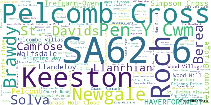
The largest settlement in the SA62 6 postal code is ST DAVIDS followed by Solva, and ROCH.
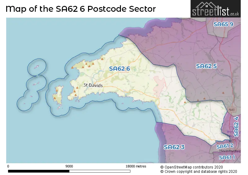
The SA62 6 Postcode shares a border with SA61 2 (HAVERFORDWEST), SA62 3 (JOHNSTON, BROAD HAVEN, ST ISHMAELS), SA62 4 (LLANGWM, CRUNDALE, HOOK) and SA62 5 (LETTERSTON, MATHRY, WOLFSCASTLE).
The sector is within the post town of HAVERFORDWEST.
SA62 6 is a postcode sector within the SA62 postcode district which is within the SA Swansea postcode area.
The Royal Mail delivery office for the SA62 6 postal sector is the Haverfordwest Delivery Office.
The area of the SA62 6 postcode sector is 56.33 square miles which is 145.90 square kilometres or 36,052.58 square acres.

Map of the SA62 6 Postcode Sector
Explore the SA62 6 postcode sector by using our free interactive map.
| S | A | 6 | 2 | - | 6 | X | X |
| S | A | 6 | 2 | Space | 6 | Letter | Letter |
Official List of Streets
Solva (29 Streets)
St. Davids (38 Streets)
Wolfsdale (1 Streets)
Brawdy (3 Streets)
Keeston (3 Streets)
Simpson Cross (10 Streets)
Roch (8 Streets)
HAVERFORDWEST (2 Streets)
Camrose (4 Streets)
Pelcomb Cross (1 Streets)
Unofficial Streets or Alternative Spellings
Croesgoch
ABEREIDDY ROADSimpson Cross
WAYSIDE CLOSEWeather Forecast for SA62 6
Press Button to Show Forecast for Porthselau (Beach)
| Time Period | Icon | Description | Temperature | Rain Probability | Wind |
|---|---|---|---|---|---|
| 00:00 to 03:00 | Cloudy | 7.0°C (feels like 6.0°C) | 5.00% | NNE 7 mph | |
| 03:00 to 06:00 | Cloudy | 7.0°C (feels like 5.0°C) | 6.00% | NE 7 mph | |
| 06:00 to 09:00 | Cloudy | 7.0°C (feels like 4.0°C) | 7.00% | ENE 7 mph | |
| 09:00 to 12:00 | Cloudy | 9.0°C (feels like 7.0°C) | 9.00% | E 9 mph | |
| 12:00 to 15:00 | Cloudy | 9.0°C (feels like 7.0°C) | 13.00% | E 9 mph | |
| 15:00 to 18:00 | Overcast | 10.0°C (feels like 8.0°C) | 15.00% | E 7 mph | |
| 18:00 to 21:00 | Overcast | 9.0°C (feels like 7.0°C) | 15.00% | NE 9 mph | |
| 21:00 to 00:00 | Cloudy | 8.0°C (feels like 6.0°C) | 11.00% | NE 9 mph |
Press Button to Show Forecast for Porthselau (Beach)
| Time Period | Icon | Description | Temperature | Rain Probability | Wind |
|---|---|---|---|---|---|
| 00:00 to 03:00 | Cloudy | 7.0°C (feels like 5.0°C) | 9.00% | NE 9 mph | |
| 03:00 to 06:00 | Partly cloudy (night) | 6.0°C (feels like 3.0°C) | 7.00% | NE 9 mph | |
| 06:00 to 09:00 | Partly cloudy (day) | 6.0°C (feels like 3.0°C) | 6.00% | ENE 9 mph | |
| 09:00 to 12:00 | Partly cloudy (day) | 9.0°C (feels like 7.0°C) | 5.00% | ENE 11 mph | |
| 12:00 to 15:00 | Cloudy | 11.0°C (feels like 9.0°C) | 9.00% | NE 11 mph | |
| 15:00 to 18:00 | Cloudy | 11.0°C (feels like 8.0°C) | 9.00% | NNE 13 mph | |
| 18:00 to 21:00 | Cloudy | 10.0°C (feels like 7.0°C) | 8.00% | NNE 13 mph | |
| 21:00 to 00:00 | Partly cloudy (night) | 8.0°C (feels like 5.0°C) | 6.00% | NNE 13 mph |
Press Button to Show Forecast for Porthselau (Beach)
| Time Period | Icon | Description | Temperature | Rain Probability | Wind |
|---|---|---|---|---|---|
| 00:00 to 03:00 | Cloudy | 8.0°C (feels like 5.0°C) | 11.00% | NNE 13 mph | |
| 03:00 to 06:00 | Cloudy | 8.0°C (feels like 4.0°C) | 12.00% | NNE 13 mph | |
| 06:00 to 09:00 | Cloudy | 8.0°C (feels like 5.0°C) | 15.00% | NNE 16 mph | |
| 09:00 to 12:00 | Cloudy | 10.0°C (feels like 6.0°C) | 14.00% | N 18 mph | |
| 12:00 to 15:00 | Partly cloudy (day) | 11.0°C (feels like 8.0°C) | 9.00% | NNW 18 mph | |
| 15:00 to 18:00 | Partly cloudy (day) | 11.0°C (feels like 8.0°C) | 8.00% | NNW 16 mph | |
| 18:00 to 21:00 | Sunny day | 10.0°C (feels like 8.0°C) | 8.00% | NW 11 mph | |
| 21:00 to 00:00 | Partly cloudy (night) | 8.0°C (feels like 6.0°C) | 5.00% | W 9 mph |
House Prices in the SA62 6 Postcode Sector
| Type of Property | 2018 Average | 2018 Sales | 2017 Average | 2017 Sales | 2016 Average | 2016 Sales | 2015 Average | 2015 Sales |
|---|---|---|---|---|---|---|---|---|
| Detached | £283,222 | 56 | £291,096 | 57 | £284,573 | 53 | £261,873 | 40 |
| Semi-Detached | £202,604 | 14 | £186,079 | 19 | £180,788 | 20 | £171,430 | 28 |
| Terraced | £219,371 | 14 | £244,600 | 10 | £220,967 | 15 | £251,000 | 8 |
| Flats | £198,650 | 3 | £182,500 | 4 | £230,000 | 4 | £180,000 | 1 |
Important Postcodes SA62 6 in the Postcode Sector
SA62 6JU is the postcode for Roch Community School, Roch
SA62 6NU is the postcode for Ysgol yr Eglwys yng Nghymru Penrhyn Dewi (VA) - Bro Dewi site, Nun Street, and Non Campus, Nun Street
SA62 6QH is the postcode for St. Davids Sports Hall, St. Davids, and Ysgol Dewi Sant, St. Davids
SA62 6TS is the postcode for Solva Community School, Solva
| The SA62 6 Sector is within these Local Authorities |
|
|---|---|
| The SA62 6 Sector is within these Counties |
|
| The SA62 6 Sector is within these Water Company Areas |
|
Tourist Attractions within the SA62 6 Postcode Area
We found 4 visitor attractions within the SA62 postcode area
| Oriel y Parc |
|---|
| View Oriel y Parc on Google Maps |
| Ramsey Island Nature Reserve |
| View Ramsey Island Nature Reserve on Google Maps |
| St David's Bishop's Palace |
| View St David's Bishop's Palace on Google Maps |
| St David's Cathedral |
| View St David's Cathedral on Google Maps |