The SA68 0 postcode sector is within the county of Dyfed.
Did you know? According to the 2021 Census, the SA68 0 postcode sector is home to a bustling 4,101 residents!
Given that each sector allows for 400 unique postcode combinations. Letters C, I, K, M, O and V are not allowed in the last two letters of a postcode. With 153 postcodes already in use, this leaves 247 units available.
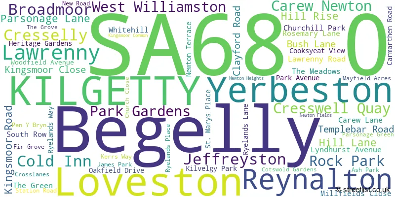
The largest settlement in the SA68 0 postal code is KILGETTY followed by BEGELLY, and CRESSELLY.
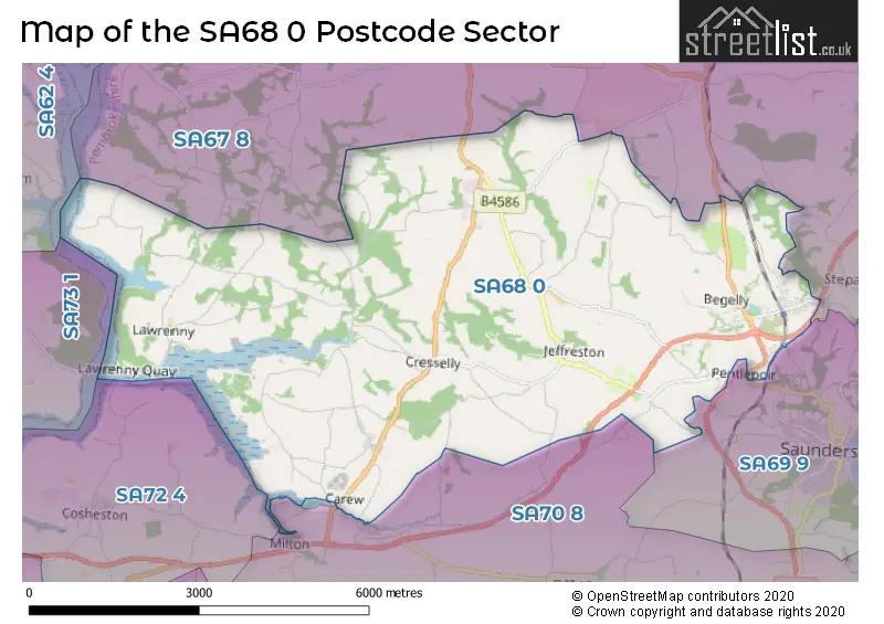
The SA68 0 Postcode shares a border with SA67 8 (TEMPLETON, STEPASIDE, NARBERTH), SA69 9 (SAUNDERSFOOT, PENTLEPOIR, WOODEN) and SA70 8 (TENBY, ST FLORENCE, SAGESTON).
The sector is within the post town of KILGETTY.
SA68 0 is a postcode sector within the SA68 postcode district which is within the SA Swansea postcode area.
The Royal Mail delivery office for the SA68 0 postal sector is the Narberth Delivery Office.
The area of the SA68 0 postcode sector is 20.80 square miles which is 53.87 square kilometres or 13,312.13 square acres.

Map of the SA68 0 Postcode Sector
Explore the SA68 0 postcode sector by using our free interactive map.
| S | A | 6 | 8 | - | 0 | X | X |
| S | A | 6 | 8 | Space | 0 | Letter | Letter |
Official List of Streets
KILGETTY (34 Streets)
Cresselly (5 Streets)
Begelly (7 Streets)
Jeffreyston (1 Streets)
Broadmoor (1 Streets)
Unofficial Streets or Alternative Spellings
Pentlepoir
GREEN PARKStepaside
KILGETTY LANEWeather Forecast for SA68 0
Press Button to Show Forecast for Carew Castle And Tidal Mill
| Time Period | Icon | Description | Temperature | Rain Probability | Wind |
|---|---|---|---|---|---|
| 09:00 to 12:00 | Overcast | 8.0°C (feels like 5.0°C) | 13.00% | ENE 11 mph | |
| 12:00 to 15:00 | Overcast | 9.0°C (feels like 6.0°C) | 14.00% | ENE 11 mph | |
| 15:00 to 18:00 | Overcast | 10.0°C (feels like 7.0°C) | 11.00% | NE 11 mph | |
| 18:00 to 21:00 | Cloudy | 9.0°C (feels like 7.0°C) | 6.00% | NNE 11 mph | |
| 21:00 to 00:00 | Cloudy | 7.0°C (feels like 5.0°C) | 4.00% | NNE 9 mph |
Press Button to Show Forecast for Carew Castle And Tidal Mill
| Time Period | Icon | Description | Temperature | Rain Probability | Wind |
|---|---|---|---|---|---|
| 00:00 to 03:00 | Cloudy | 7.0°C (feels like 4.0°C) | 3.00% | N 9 mph | |
| 03:00 to 06:00 | Partly cloudy (night) | 6.0°C (feels like 3.0°C) | 1.00% | N 9 mph | |
| 06:00 to 09:00 | Partly cloudy (day) | 7.0°C (feels like 4.0°C) | 2.00% | N 9 mph | |
| 09:00 to 12:00 | Partly cloudy (day) | 10.0°C (feels like 8.0°C) | 2.00% | NNW 13 mph | |
| 12:00 to 15:00 | Partly cloudy (day) | 11.0°C (feels like 9.0°C) | 4.00% | NW 13 mph | |
| 15:00 to 18:00 | Partly cloudy (day) | 11.0°C (feels like 9.0°C) | 1.00% | W 13 mph | |
| 18:00 to 21:00 | Partly cloudy (day) | 10.0°C (feels like 8.0°C) | 2.00% | WSW 11 mph | |
| 21:00 to 00:00 | Cloudy | 8.0°C (feels like 6.0°C) | 4.00% | SW 11 mph |
Press Button to Show Forecast for Carew Castle And Tidal Mill
| Time Period | Icon | Description | Temperature | Rain Probability | Wind |
|---|---|---|---|---|---|
| 00:00 to 03:00 | Cloudy | 9.0°C (feels like 6.0°C) | 6.00% | SSW 13 mph | |
| 03:00 to 06:00 | Cloudy | 9.0°C (feels like 6.0°C) | 8.00% | SSW 16 mph | |
| 06:00 to 09:00 | Cloudy | 10.0°C (feels like 7.0°C) | 10.00% | S 18 mph | |
| 09:00 to 12:00 | Cloudy | 11.0°C (feels like 7.0°C) | 19.00% | S 22 mph | |
| 12:00 to 15:00 | Cloudy | 12.0°C (feels like 8.0°C) | 21.00% | S 22 mph | |
| 15:00 to 18:00 | Heavy rain shower (day) | 12.0°C (feels like 8.0°C) | 56.00% | S 20 mph | |
| 18:00 to 21:00 | Light rain shower (day) | 11.0°C (feels like 8.0°C) | 42.00% | SSE 20 mph | |
| 21:00 to 00:00 | Cloudy | 11.0°C (feels like 7.0°C) | 20.00% | SSE 20 mph |
Press Button to Show Forecast for Carew Castle And Tidal Mill
| Time Period | Icon | Description | Temperature | Rain Probability | Wind |
|---|---|---|---|---|---|
| 00:00 to 03:00 | Heavy rain | 10.0°C (feels like 7.0°C) | 71.00% | SSE 20 mph | |
| 03:00 to 06:00 | Heavy rain | 10.0°C (feels like 7.0°C) | 70.00% | SE 18 mph | |
| 06:00 to 09:00 | Light rain | 10.0°C (feels like 7.0°C) | 52.00% | SE 18 mph | |
| 09:00 to 12:00 | Heavy rain | 11.0°C (feels like 8.0°C) | 73.00% | SE 20 mph | |
| 12:00 to 15:00 | Light rain | 12.0°C (feels like 9.0°C) | 50.00% | SE 18 mph | |
| 15:00 to 18:00 | Light rain shower (day) | 13.0°C (feels like 10.0°C) | 33.00% | SE 16 mph | |
| 18:00 to 21:00 | Cloudy | 12.0°C (feels like 10.0°C) | 15.00% | SE 13 mph | |
| 21:00 to 00:00 | Partly cloudy (night) | 10.0°C (feels like 8.0°C) | 8.00% | ESE 11 mph |
House Prices in the SA68 0 Postcode Sector
| Type of Property | 2018 Average | 2018 Sales | 2017 Average | 2017 Sales | 2016 Average | 2016 Sales | 2015 Average | 2015 Sales |
|---|---|---|---|---|---|---|---|---|
| Detached | £212,014 | 79 | £208,756 | 61 | £212,020 | 56 | £226,912 | 41 |
| Semi-Detached | £167,046 | 24 | £152,184 | 31 | £158,781 | 16 | £142,582 | 11 |
| Terraced | £143,571 | 7 | £157,500 | 5 | £156,500 | 5 | £146,500 | 2 |
| Flats | £90,500 | 3 | £77,833 | 3 | £82,500 | 3 | £81,333 | 3 |
Important Postcodes SA68 0 in the Postcode Sector
SA68 0SG is the postcode for St. Oswalds VA School, Jeffreyston, and St. Oswalds Church in Wales V A School, Jeffreyston
SA68 0UG is the postcode for Stepaside Cp School, Carmarthen Road
| The SA68 0 Sector is within these Local Authorities |
|
|---|---|
| The SA68 0 Sector is within these Counties |
|
| The SA68 0 Sector is within these Water Company Areas |
|
Tourist Attractions within the SA68 0 Postcode Area
We found 1 visitor attractions within the SA68 postcode area
| Folly Farm |
|---|
| View Folly Farm on Google Maps |