SE1 9JA is a postal code used within the United Kingdom for delivering mail.
Postcodes are made up of two parts. The part before the space (SE1) is called the outward code. The part after the space (9JA) is called the inward code. The letters C, I, K, M, O and V are not allowed in the inward code. In addition to the inward and outward code, the postcode can be broken up into four parts:
- Postal Area. In our case SE which means London - SE.
- Postal District. In our case SE1.
- Postal Sector. In our case SE1 9.
- Postcode Unit. The last two letters. In our case JA.
The regional mail center for the post area SE is the Princess Royal Distribution Centre, which is located at Blackmore Drive, North Circular, LONDON , NW10 7RH.
The final port of call for any post addressed to the SE1 9JA postcode is the local delivery office (DO) which is SOUTHWARK SDO. Here the post will be sorted ready for delivery.
The properties in the SE1 9JA postcode have the street address of Sumner Street
Did you know? According to the 2021 Census, the SE1 9JA postcode is home to a bustling 360 residents!
It is situated within the post town of LONDON within the old postal county of Surrey.
SE1 9JA is within Bankside.
Our data shows that SE1 9JA is a residential postcode.
The SE1 9JA postcode area is composed of 0% residential properties, 6.25% commercial properties, and 93.75% public properties.
None Domestic Buildings in SE1 9JA fall under these categories: Education.
Education include Bankside House 24, Sumner Street.

Interactive Mapping Showing UPRNs within the SE1 9JA Postcode Boundaries
Use the search box to search for other postcodes or places.
Map of the SE1 9JA Postcode

SE1 9JA: Points of Interest
London school of economics student accommodation
London school of economics student accommodation is an establishment offering meals and refreshments located at Bankside House, 24, Sumner Street, London, SE1 9JA.
| Property Type | Percentage |
|---|---|
| Residential | 0% |
| Commercial | 6.25% |
| Public | 93.75% |
Telephone Area Code for SE1 9JA
The telephone area code for SE1 9JA is 020 London.
Map Coordinates for SE1 9JA
| Latitude | 51.506417723 |
|---|---|
| Longitude | -0.0986564959499 |
Ordnance Survey Maps for SE1 9JA
| Map Series | Amazon | Ordnance Survey |
| Explorer 1:25,000 173 London North, The City, West End, Enfield, Ealing, Harrow & Watford | Check Price on Amazon | Buy Direct from the Ordnance Survey |
| Landranger 1:50,000 176 West London | Check Price on Amazon | Buy Direct from the Ordnance Survey |
| Landranger 1:50,000 177 East London | Check Price on Amazon | Buy Direct from the Ordnance Survey |
Weather Forecast for SE1 9JA
Mon 29th Apr
Press Button to Show Forecast for City Of London Youth Hostel
| Time Period | Icon | Description | Temperature | Rain Probability | Wind |
|---|---|---|---|---|---|
| 03:00 to 06:00 | Clear night | 8.0°C (feels like 6.0°C) | 0.00% | SSW 7 mph | |
| 06:00 to 09:00 | Sunny day | 8.0°C (feels like 7.0°C) | 0.00% | SSW 7 mph | |
| 09:00 to 12:00 | Partly cloudy (day) | 13.0°C (feels like 10.0°C) | 1.00% | SSW 11 mph | |
| 12:00 to 15:00 | Sunny day | 16.0°C (feels like 12.0°C) | 0.00% | SSW 13 mph | |
| 15:00 to 18:00 | Sunny day | 16.0°C (feels like 13.0°C) | 0.00% | SSW 13 mph | |
| 18:00 to 21:00 | Sunny day | 15.0°C (feels like 12.0°C) | 0.00% | SSW 11 mph | |
| 21:00 to 00:00 | Clear night | 12.0°C (feels like 11.0°C) | 0.00% | SSE 7 mph |
Tue 30th Apr
Press Button to Show Forecast for City Of London Youth Hostel
| Time Period | Icon | Description | Temperature | Rain Probability | Wind |
|---|---|---|---|---|---|
| 00:00 to 03:00 | Clear night | 11.0°C (feels like 9.0°C) | 0.00% | SE 7 mph | |
| 03:00 to 06:00 | Clear night | 10.0°C (feels like 9.0°C) | 0.00% | SE 4 mph | |
| 06:00 to 09:00 | Sunny day | 10.0°C (feels like 9.0°C) | 1.00% | SE 4 mph | |
| 09:00 to 12:00 | Sunny day | 15.0°C (feels like 13.0°C) | 2.00% | SE 9 mph | |
| 12:00 to 15:00 | Cloudy | 17.0°C (feels like 14.0°C) | 8.00% | SSE 11 mph | |
| 15:00 to 18:00 | Cloudy | 16.0°C (feels like 14.0°C) | 10.00% | SSE 9 mph | |
| 18:00 to 21:00 | Cloudy | 16.0°C (feels like 14.0°C) | 10.00% | SSE 7 mph | |
| 21:00 to 00:00 | Partly cloudy (night) | 13.0°C (feels like 12.0°C) | 8.00% | SSE 7 mph |
Wed 1st May
Press Button to Show Forecast for City Of London Youth Hostel
| Time Period | Icon | Description | Temperature | Rain Probability | Wind |
|---|---|---|---|---|---|
| 00:00 to 03:00 | Cloudy | 12.0°C (feels like 11.0°C) | 8.00% | SE 4 mph | |
| 03:00 to 06:00 | Cloudy | 11.0°C (feels like 10.0°C) | 9.00% | SSE 4 mph | |
| 06:00 to 09:00 | Cloudy | 11.0°C (feels like 11.0°C) | 10.00% | SSW 4 mph | |
| 09:00 to 12:00 | Cloudy | 13.0°C (feels like 13.0°C) | 11.00% | NE 4 mph | |
| 12:00 to 15:00 | Cloudy | 16.0°C (feels like 16.0°C) | 11.00% | ENE 4 mph | |
| 15:00 to 18:00 | Cloudy | 17.0°C (feels like 16.0°C) | 15.00% | NE 7 mph | |
| 18:00 to 21:00 | Cloudy | 16.0°C (feels like 15.0°C) | 12.00% | NE 7 mph | |
| 21:00 to 00:00 | Cloudy | 14.0°C (feels like 13.0°C) | 13.00% | NNW 7 mph |
Thu 2nd May
Press Button to Show Forecast for City Of London Youth Hostel
| Time Period | Icon | Description | Temperature | Rain Probability | Wind |
|---|---|---|---|---|---|
| 00:00 to 03:00 | Light rain shower (night) | 12.0°C (feels like 11.0°C) | 46.00% | N 7 mph | |
| 03:00 to 06:00 | Overcast | 11.0°C (feels like 10.0°C) | 13.00% | NNW 7 mph | |
| 06:00 to 09:00 | Cloudy | 11.0°C (feels like 10.0°C) | 13.00% | NW 7 mph | |
| 09:00 to 12:00 | Overcast | 13.0°C (feels like 12.0°C) | 14.00% | NW 7 mph | |
| 12:00 to 15:00 | Cloudy | 17.0°C (feels like 16.0°C) | 8.00% | NW 7 mph | |
| 15:00 to 18:00 | Partly cloudy (day) | 19.0°C (feels like 17.0°C) | 6.00% | NNW 9 mph | |
| 18:00 to 21:00 | Cloudy | 18.0°C (feels like 16.0°C) | 8.00% | NNW 9 mph | |
| 21:00 to 00:00 | Partly cloudy (night) | 15.0°C (feels like 13.0°C) | 4.00% | NW 9 mph |
Schools within a five minute drive of SE1 9JA Postcode
England Secondary Schools
St Michael's Catholic College
Address: St Michael's Catholic College, Llewellyn Street, Bermondsey, London, SE16 4UN
Distance: 1.42 miles
Contact: 02072376432
Ark Globe Academy
Address: Ark Globe Academy, Harper Road, London, SE1 6AG
Distance: 0.83 miles
Contact: 02074076877
Oasis Academy South Bank
Address: Oasis Academy South Bank, 75 Westminster Bridge Road, London, SE1 7HS
Distance: 0.79 miles
Contact: 02079214200
St Saviour's and St Olave's Church of England School
Address: St Saviour's and St Olave's Church of England School, New Kent Road, London, SE1 4AN
Distance: 0.94 miles
Contact: 02074071843
London Nautical School
Address: London Nautical School, 61 Stamford Street, Waterloo, London, SE1 9NA
Distance: 0.41 miles
Contact: 02079286801
Notre Dame Roman Catholic Girls' School
Address: Notre Dame Roman Catholic Girls' School, 118 St George's Road, London, SE1 6EX
Distance: 0.73 miles
Contact:
England Primary Schools
The Aldgate School
Address: The Aldgate School, St James's Passage, Duke's Place, London, EC3A 5DE
Distance: 1.04 miles
Contact: 02072831147
St Joseph's Roman Catholic Primary School
Address: St Joseph's Roman Catholic Primary School, George Row, Bermondsey, London, SE16 4UP
Distance: 1.36 miles
Contact:
St James' Church of England Primary School
Address: St James' Church of England Primary School, Old Jamaica Road, Bermondsey, London, SE16 4SU
Distance: 1.45 miles
Contact: 02072373111
Snowsfields Primary School
Address: Snowsfields Primary School, Kirby Grove, London, SE1 3TD
Distance: 0.72 miles
Contact: 02075259065
Tower Bridge Primary School
Address: Tower Bridge Primary School, Fair Street, London, SE1 2AE
Distance: 0.99 miles
Contact: 02074072959
The Cathedral School of St Saviour and St Mary Overie
Address: The Cathedral School of St Saviour and St Mary Overie, Redcross Way, Southwark, LONDON, SE1 1HG
Distance: 0.31 miles
Contact: 02074072600
Saint Joseph's Catholic Primary School, the Borough
Address: Saint Joseph's Catholic Primary School, the Borough, Little Dorrit Court, Redcross Way, London, SE1 1NJ
Distance: 0.35 miles
Contact: 02074072642
Grange Primary School
Address: Grange Primary School, Webb Street, London, SE1 4RP
Distance: 1.03 miles
Contact: 02077716121
Townsend Primary School
Address: Townsend Primary School, Townsend Street, London, SE17 1HJ
Distance: 1.13 miles
Contact:
Crampton Primary
Address: Crampton Primary, Iliffe Street, Walworth, London, SE17 3LE
Distance: 1.14 miles
Contact: 02077352219
Victory Primary School
Address: Victory Primary School, Elba Place, Rodney Road, London, SE17 1PT
Distance: 0.96 miles
Contact: 02077035722
Charles Dickens Primary School
Address: Charles Dickens Primary School, Toulmin Street, London, SE1 1AF
Distance: 0.37 miles
Contact:
Friars Primary Foundation School
Address: Friars Primary Foundation School, Webber Street, Blackfriars, London, SE1 0RF
Distance: 0.41 miles
Contact: 02072071807
Charlotte Sharman Primary School
Address: Charlotte Sharman Primary School, St George's Road, West Square, London, SE11 4SN
Distance: 0.84 miles
Contact: 02077355598
St Jude's Church of England Primary School
Address: St Jude's Church of England Primary School, Colnbrook Street, London, SE1 6HA
Distance: 0.72 miles
Contact: 02079285484
St George's Cathedral Catholic Primary School
Address: St George's Cathedral Catholic Primary School, 28 Lambeth Road, London, SE1 6HR
Distance: 0.69 miles
Contact: 02075259250
Oasis Academy Johanna
Address: Oasis Academy Johanna, Johanna Street, Lower Marsh, London, SE1 7RH
Distance: 0.68 miles
Contact: 02079285814
England Higher Schools
Morley College London
Address: Morley College London, 61 Westminster Bridge Road, Waterloo, London, SE1 7HT
Distance: 0.77 miles
Contact: 02074501889
King's College London Maths School
Address: King's College London Maths School, 80 Kennington Road, London, SE11 6NJ
Distance: 0.91 miles
Contact: 02078487346
Nearest Dentists
Dentists near SE1 9JA
SENSU - TALBOT YARD
Address: 85-87 BOROUGH HIGH STREET, LONDON, SE1 1NH
Distance: 0.38 miles
Contact: :
BUPA DENTAL CARE - CANNON STREET
Address: CANNONGATE HOUSE, 62-64 CANNON STREET, LONDON, EC4N 6AE
Distance: 0.48 miles
Contact: :
DENTAL SURGERY
Address: 305 BOROUGH HIGH STREET, LONDON, GREATER LONDON, SE1 1JH
Distance: 0.48 miles
Contact: :
WELLINGTON HOUSE (DENTAL SURGERY)
Address: 133-155 WATERLOO ROAD, LONDON, SE1 8UG
Distance: 0.54 miles
Contact: :
DENTAL SURGERY
Address: 223 WATERLOO ROAD, LONDON, GREATER LONDON, SE1 8XH
Distance: 0.58 miles
Contact: :
SMILERIGHT DENTAL CLINIC AT WATERLOO
Address: 268 WATERLOO ROAD, LONDON, SE1 8RQ
Distance: 0.61 miles
Contact: :
Nearest Chemists
Pharmacies near SE1 9JA
KALMAK (CHEMISTS) LTD
Address: UNIT 11 SOUTH BANK TOWER, UPPER GROUND, LONDON, GREATER LONDON, SE1 9LP
Distance: 0.34 miles
Contact: tel: 020 76330552
PHARMACEUTRA
Address: 64 BOROUGH HIGH STREET, LONDON, SE1 1XF
Distance: 0.35 miles
Contact: tel: 02045 374441
CITY PHARMACY
Address: 39-41 BOROUGH HIGH STREET, LONDON, GREATER LONDON, SE1 1LZ
Distance: 0.40 miles
Contact: tel: 020 74072061
QRYSTAL PHARMACY
Address: 301-303 BOROUGH HIGH STREET, LONDON, SE1 1JH
Distance: 0.48 miles
Contact: tel: 02074 032237
BOOTS
Address: 80 CANNON STREET, LONDON, GREATER LONDON, EC4N 6HL
Distance: 0.51 miles
Contact: tel: 020 76234676
BOOTS
Address: 21 NEW CHANGE PASSAGE, LONDON, GREATER LONDON, EC4M 9AG
Distance: 0.53 miles
Contact: tel: 02072 483635
Nearest Opticians
Opticians near SE1 9JA
QUINLANS OPTICIANS
Address: 7 BEDALE STREET, LONDON, GREATER LONDON, SE1 9AL
Distance: 0.38 miles
Contact: :
G F BARNES OPTICIANS
Address: 153 BOROUGH HIGH STREET, LONDON, GREATER LONDON, SE1 1HR
Distance: 0.39 miles
Contact: :
EYELINK
Address: 11 LUDGATE BROADWAY, LONDON, GREATER LONDON, EC4V 6DU
Distance: 0.52 miles
Contact: :
BOOTS OPTICIANS (CHEAPSIDE, LONDON)
Address: UNIT 7, PATERNOSTER SQUARE, LONDON, GREATER LONDON, EC4M 7DX
Distance: 0.57 miles
Contact: :
DAVID CLULOW OPTICIANS (CHEAPSIDE)
Address: 137 CHEAPSIDE, LONDON, EC2V 6BJ
Distance: 0.57 miles
Contact: :
THE INSTITUTE OF OPTOMETRY
Address: 56-62 NEWINGTON CAUSEWAY, LONDON, GREATER LONDON, SE1 6DS
Distance: 0.58 miles
Contact: :
Nearest GP Surgeries
Doctors near SE1 9JA
BLACKFRIARS MEDICAL PRACTICE
Address: BLACKFRIARS MEDICAL PRACT, 45 COLOMBO STREET, LONDON, GREATER LONDON, SE1 8EE
Distance: 0.31 miles
Contact: tel: 020 79286216
FALMOUTH ROAD GROUP PRACTICE
Address: 78 FALMOUTH ROAD, LONDON, GREATER LONDON, SE1 4JW
Distance: 0.71 miles
Contact: tel: 020 74074101
WATERLOO HEALTH CENTRE
Address: 114-118 LOWER MARSH, WATERLOO, LONDON, SE1 7AE
Distance: 0.75 miles
Contact: tel: 020 79284049
NEXUS HEALTH GROUP
Address: PRINCESS STREET GROUP PRACTICE, 2 PRINCESS STREET, LONDON, GREATER LONDON, SE1 6JP
Distance: 0.76 miles
Contact: tel: 02079 283299
THE NEAMAN PRACTICE
Address: 15 HALF MOON COURT, LONDON, GREATER LONDON, EC1A 7HF
Distance: 0.87 miles
Contact: tel: 020 76009740
ST PHILIPS MEDICAL CENTRE
Address: TOWER 3, 2ND FLOOR CLEMENTS INN, LONDON, GREATER LONDON, WC2A 2AZ
Distance: 0.88 miles
Contact: tel: 020 76115131
Transport Links near SE1 9JA
Train Stations
Nearest stations for postcode: SE1 9JA
- London Cannon Street
London Cannon Street station, Cannon Street, London, Greater London, EC4N 6APDistance: 0.77 milesDriving Time: 2.49 minutes - London Bridge
London Bridge station, Tooley Street / St Thomas Street, London, Greater London, SE1 3QXDistance: 0.77 milesDriving Time: 2.34 minutes - London Blackfriars
London Blackfriars station, Queen Victoria Street, London, EC4V 4DYDistance: 0.90 milesDriving Time: 2.88 minutes - City Thameslink
City Thameslink station, Ludgate Hill, London, EC4M 7JHDistance: 1.04 milesDriving Time: 3.35 minutes - London Waterloo East
London Waterloo East station, Sandell Street, London, SE1 8NHDistance: 1.15 milesDriving Time: 3.72 minutes
Distances represent the quickest route by car.
Motorway Junctions near SE1 9JA
Train Stations
Motorway Junctions near SE1 9JA
Distances represent the quickest route by car.
Who are my Elected Representatives in the SE1 9JA Postcode?
| Westminster Constituency | Bermondsey and Old Southwark Boro Const |
|---|---|
| Member or Parliament | 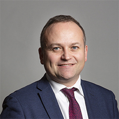 |
| Contact Details | Contact Neil Coyle |
| Political Party | Independent |
What Council is the SE1 9JA Postcode in?
The Local Council for this Postcode is Southwark London Boro Council and the County Council is Greater London Authority Council.
Greater London Authority Council is responsible for providing education, libraries and maintaining highways.
Southwark London Boro Council is responsible for duties such as council tax, rubbish collection, housing, environmental health and planning.
You can visit the website for Southwark London Boro at the following link Southwark London Boro.How much is the Council Tax?
Southwark London Boro Council is responsible for collecting council tax. This will vary depending on which council tax band the property falls within. You can check the council tax band at the gov.uk website.
Once you know the council tax band you can view how much Southwark London Boro charge for that band by visiting the The Council Tax section of their website.
Planning Applications
When moving house to a new post code it is worth checking out what will be built in the neighbourhood.
Few people want to live next door to a building site, have their garden overlooked or have the views from their property ruined.
Visit the local planning department and search for planning applications in this postcode granted within the last three years or still awaiting a decision. This will give an indication of what could still be built.
Where can I find out where the nearest Library to the SE1 9JA Postcode is?
Libraries are the responsibility of Southwark council
Visit the link for more information. Please note that some councils outsource library services to private companies and community groups ran by volunteers.
Libraries - Southwark CouncilPostcodes near the SE1 9JA Postcode
What Popular Supermarkets are near the SE1 9JA Postcode?
| Supermarket | Distance | Directions |
|---|---|---|
| Waitrose, Upper Ground, Southwark, LONDON, SE1 9LS | 0.51 miles | Directions from SE1 9JA to Waitrose |
| Iceland, Lower Marsh, Lambeth, LONDON, SE1 7AE | 1.20 miles | Directions from SE1 9JA to Iceland |
| Iceland, Unit 300/304, Elephant and Castle Centre, London, SE1 6TB | 1.33 miles | Directions from SE1 9JA to Iceland |
| Sainsburys, New Kent Road, Southwark, LONDON, SE1 6TJ | 1.35 miles | Directions from SE1 9JA to Sainsburys |
| Waitrose, Cherry Tree Walk, Islington, LONDON, EC1Y 8NX | 1.77 miles | Directions from SE1 9JA to Waitrose |
What Popular Restaurants are near the SE1 9JA Postcode?
| Burger King | Distance | Directions |
|---|---|---|
| Waterloo Railway Station, London, SE1 8SE | 0.63 miles | Directions from SE1 9JA to Waterloo Railway Station |
| Fenchurch St Station, London, EC3M 4AJ | 0.92 miles | Directions from SE1 9JA to Fenchurch St Station |
| Charing Cross Station, London, WC2N 5HS | 1.13 miles | Directions from SE1 9JA to Charing Cross Station |
| 117 Kingsway, London, WC2B 6PP | 1.17 miles | Directions from SE1 9JA to 117 Kingsway |
| Mcdonald's | Distance | Directions |
|---|---|---|
| McDonald's, Ludgate Hill, City of London, LONDON, EC4M 7AA | 0.51 miles | Directions from SE1 9JA to McDonald's, Ludgate Hill, City of London, LONDON, EC4M 7AA |
| McDonald's, Tooley Street, Southwark, LONDON, SE1 2TF | 0.56 miles | Directions from SE1 9JA to McDonald's, Tooley Street, Southwark, LONDON, SE1 2TF |
| McDonald's, The Colonnade, Waterloo Road, Lambeth, LONDON, SE1 8SF | 0.61 miles | Directions from SE1 9JA to McDonald's, The Colonnade, Waterloo Road, Lambeth, LONDON, SE1 8SF |
| McDonald's, Holborn, City of London, LONDON, EC1N 2LL | 0.95 miles | Directions from SE1 9JA to McDonald's, Holborn, City of London, LONDON, EC1N 2LL |
| Restaurant | Distance | Directions |
|---|---|---|
| KFC, Borough High Street, Southwark, LONDON, SE1 1LB | 0.37 miles | Directions from SE1 9JA to KFC Borough - High Street |
| KFC, Fleet Street, City of London, LONDON, EC4Y 1HT | 0.66 miles | Directions from SE1 9JA to KFC London - Fleet Street |
| KFC, Tower Hill Terrace, Tower Hamlets, LONDON, EC3N 4EE | 0.89 miles | Directions from SE1 9JA to KFC London - Tower Hill |
| KFC, Farringdon Road, Camden, LONDON, EC1M 3JB | 1.02 miles | Directions from SE1 9JA to KFC London - Farringdon Road |
| KFC, Bishopsgate, City of London, LONDON, EC2M 4NQ | 1.10 miles | Directions from SE1 9JA to KFC Bishopsgate |