SE16 6SD is a postal code used within the United Kingdom for delivering mail.
Postcodes are made up of two parts. The part before the space (SE16) is called the outward code. The part after the space (6SD) is called the inward code. The letters C, I, K, M, O and V are not allowed in the inward code. In addition to the inward and outward code, the postcode can be broken up into four parts:
- Postal Area. In our case SE which means London - SE.
- Postal District. In our case SE16.
- Postal Sector. In our case SE16 6.
- Postcode Unit. The last two letters. In our case SD.
The regional mail center for the post area SE is the Princess Royal Distribution Centre, which is located at Blackmore Drive, North Circular, LONDON , NW10 7RH.
The final port of call for any post addressed to the SE16 6SD postcode is the local delivery office (DO) which is ROTHERHITHE SDO. Here the post will be sorted ready for delivery.
The properties in the SE16 6SD postcode have the street address of St. Elmos Road
It is situated within the post town of LONDON within the old postal county of Surrey.
SE16 6SD is within Rotherhithe.
According to our data SE16 6SD is a commercial postcode.
The SE16 6SD postcode area is composed of 0% residential properties, 0% commercial properties, and 100% public properties.
Interactive Mapping Showing UPRNs within the SE16 6SD Postcode Boundaries
Use the search box to search for other postcodes or places.
Map of the SE16 6SD Postcode

| Property Type | Percentage |
|---|---|
| Residential | 0% |
| Commercial | 0% |
| Public | 100% |
Telephone Area Code for SE16 6SD
The telephone area code for SE16 6SD is 020 London.
Map Coordinates for SE16 6SD
| Latitude | 51.5002975539 |
|---|---|
| Longitude | -0.041509438051 |
Ordnance Survey Maps for SE16 6SD
| Map Series | Amazon | Ordnance Survey |
| Explorer 1:25,000 162 Greenwich and Gravesend | Check Price on Amazon | Buy Direct from the Ordnance Survey |
| Explorer 1:25,000 173 London North, The City, West End, Enfield, Ealing, Harrow & Watford | Check Price on Amazon | Buy Direct from the Ordnance Survey |
| Landranger 1:50,000 177 East London | Check Price on Amazon | Buy Direct from the Ordnance Survey |
Weather Forecast for SE16 6SD
Tue 30th Apr
Press Button to Show Forecast for Rotherhithe Youth Hostel
| Time Period | Icon | Description | Temperature | Rain Probability | Wind |
|---|---|---|---|---|---|
| 00:00 to 03:00 | Clear night | 10.0°C (feels like 8.0°C) | 0.00% | SSE 7 mph | |
| 03:00 to 06:00 | Clear night | 9.0°C (feels like 7.0°C) | 0.00% | SE 7 mph | |
| 06:00 to 09:00 | Sunny day | 10.0°C (feels like 9.0°C) | 1.00% | SE 4 mph | |
| 09:00 to 12:00 | Sunny day | 15.0°C (feels like 14.0°C) | 1.00% | SSE 9 mph | |
| 12:00 to 15:00 | Cloudy | 17.0°C (feels like 14.0°C) | 6.00% | SSE 11 mph | |
| 15:00 to 18:00 | Cloudy | 16.0°C (feels like 14.0°C) | 10.00% | SSE 11 mph | |
| 18:00 to 21:00 | Cloudy | 15.0°C (feels like 14.0°C) | 11.00% | SSE 7 mph | |
| 21:00 to 00:00 | Cloudy | 12.0°C (feels like 11.0°C) | 12.00% | SE 4 mph |
Wed 1st May
Press Button to Show Forecast for Rotherhithe Youth Hostel
| Time Period | Icon | Description | Temperature | Rain Probability | Wind |
|---|---|---|---|---|---|
| 00:00 to 03:00 | Cloudy | 11.0°C (feels like 10.0°C) | 10.00% | SSE 4 mph | |
| 03:00 to 06:00 | Partly cloudy (night) | 10.0°C (feels like 9.0°C) | 7.00% | SSE 4 mph | |
| 06:00 to 09:00 | Cloudy | 10.0°C (feels like 10.0°C) | 9.00% | SSW 4 mph | |
| 09:00 to 12:00 | Cloudy | 13.0°C (feels like 13.0°C) | 9.00% | NNW 2 mph | |
| 12:00 to 15:00 | Cloudy | 15.0°C (feels like 15.0°C) | 12.00% | NNE 4 mph | |
| 15:00 to 18:00 | Cloudy | 16.0°C (feels like 15.0°C) | 17.00% | NE 7 mph | |
| 18:00 to 21:00 | Cloudy | 15.0°C (feels like 14.0°C) | 18.00% | NE 7 mph | |
| 21:00 to 00:00 | Cloudy | 13.0°C (feels like 13.0°C) | 18.00% | NW 4 mph |
Thu 2nd May
Press Button to Show Forecast for Rotherhithe Youth Hostel
| Time Period | Icon | Description | Temperature | Rain Probability | Wind |
|---|---|---|---|---|---|
| 00:00 to 03:00 | Light rain shower (night) | 12.0°C (feels like 11.0°C) | 38.00% | NNW 4 mph | |
| 03:00 to 06:00 | Cloudy | 11.0°C (feels like 10.0°C) | 13.00% | NNW 4 mph | |
| 06:00 to 09:00 | Overcast | 11.0°C (feels like 10.0°C) | 16.00% | NW 7 mph | |
| 09:00 to 12:00 | Overcast | 14.0°C (feels like 13.0°C) | 15.00% | NW 7 mph | |
| 12:00 to 15:00 | Cloudy | 17.0°C (feels like 15.0°C) | 10.00% | NW 9 mph | |
| 15:00 to 18:00 | Cloudy | 18.0°C (feels like 17.0°C) | 9.00% | NW 9 mph | |
| 18:00 to 21:00 | Cloudy | 17.0°C (feels like 16.0°C) | 10.00% | NW 9 mph | |
| 21:00 to 00:00 | Partly cloudy (night) | 15.0°C (feels like 13.0°C) | 5.00% | NW 9 mph |
Schools within a five minute drive of SE16 6SD Postcode
England Primary Schools
Redriff Primary School
Address: Redriff Primary School, Salter Road, Rotherhithe, London, SE16 5LQ
Distance: 0.24 miles
Contact: 02072374272
Redriff Primary School
Address: Redriff Primary School, Salter Road, Rotherhithe, London, SE16 5LQ
Distance: 0.24 miles
Contact:
St John's Roman Catholic Primary School
Address: St John's Roman Catholic Primary School, St Elmo's Road, London, SE16 6SD
Distance: 0.00 miles
Contact: 02072521859
Peter Hills with St Mary's and St Paul's CofE Primary School
Address: Peter Hills with St Mary's and St Paul's CofE Primary School, 2 Beatson Walk, Rotherhithe, London, SE16 5ED
Distance: 0.41 miles
Contact: 02072372654
Alfred Salter Primary School
Address: Alfred Salter Primary School, Quebec Way, Rotherhithe, London, SE16 7LP
Distance: 0.10 miles
Contact: 02072523676
Rotherhithe Primary School
Address: Rotherhithe Primary School, 61 Hawkstone Road, London, SE16 2PE
Distance: 0.67 miles
Contact:
Albion Primary School
Address: Albion Primary School, Albion Street, Rotherhithe, London, SE16 7JD
Distance: 0.44 miles
Contact: 02072373738
St Joseph's Catholic Primary School
Address: St Joseph's Catholic Primary School, Gomm Road, Lower Road, Rotherhithe, London, SE16 2TY
Distance: 0.62 miles
Contact: 02072374036
Southwark Park Primary School
Address: Southwark Park Primary School, 383 Southwark Park Road, Bermondsey, Southwark, London, SE16 2JH
Distance: 0.85 miles
Contact: 02073944000
Riverside Primary School
Address: Riverside Primary School, Janeway Street, London, SE16 4PS
Distance: 0.97 miles
Contact: 02072373227
St Joseph's Roman Catholic Primary School
Address: St Joseph's Roman Catholic Primary School, George Row, Bermondsey, London, SE16 4UP
Distance: 1.20 miles
Contact:
St James' Church of England Primary School
Address: St James' Church of England Primary School, Old Jamaica Road, Bermondsey, London, SE16 4SU
Distance: 1.14 miles
Contact: 02072373111
England Secondary Schools
Bacon's College
Address: Bacon's College, Timber Pond Road, Rotherhithe, London, SE16 6AT
Distance: 0.15 miles
Contact:
The Charter School Bermondsey
Address: The Charter School Bermondsey, Keeton's Road, London, SE16 4EE
Distance: 0.94 miles
Contact: 02035426506
St Michael's Catholic College
Address: St Michael's Catholic College, Llewellyn Street, Bermondsey, London, SE16 4UN
Distance: 1.12 miles
Contact: 02072376432
Nearest Dentists
Dentists near SE16 6SD
SURREY DOCKS DENTAL PRACTICE
Address: DOWNTOWN HEALTH CENTRE, 13 BLONDIN WAY, LONDON, GREATER LONDON, SE16 6BD
Distance: 0.23 miles
Contact: :
CANADA WATER DENTAL HEALTH
Address: TORONTO HOUSE, SURREY QUAYS ROAD, LONDON, GREATER LONDON, SE16 7AJ
Distance: 0.30 miles
Contact: :
DENTAL SURGERY
Address: 36 BRUNEL ROAD, LONDON, GREATER LONDON, SE16 6HZ
Distance: 0.36 miles
Contact: :
DAKATRA
Address: UNIT 2-3, CITY BUSINESS CENTRE, LOWER ROAD, LONDON, SE16 2XB
Distance: 0.57 miles
Contact: :
CBC DENTAL STUDIO
Address: UNIT 5, CITY BUSINESS CENTRE, LOWER ROAD, LONDON, SE16 2XB
Distance: 0.57 miles
Contact: :
UNIT 2-3
Address: CITY BUSINESS CENTRE, LOWER ROAD, LONDON, SE16 2XB
Distance: 0.57 miles
Contact: :
Nearest Chemists
Pharmacies near SE16 6SD
BOOTS
Address: 11-13 SURREY QUAYS SHOPPING CENTRE, REDRIFF ROAD, LONDON, GREATER LONDON, SE16 7LL
Distance: 0.41 miles
Contact: tel: 020 72520084
TESCO INSTORE PHARMACY
Address: SURREY QUAYS SHOPPING CENTRE, REDRIFF ROAD, LONDON, GREATER LONDON, SE16 7LL
Distance: 0.41 miles
Contact: tel: 03456 779636
CAMPION & CO CHEMIST
Address: 38 ALBION STREET, LONDON, GREATER LONDON, SE16 7JQ
Distance: 0.49 miles
Contact: tel: 020 72371193
SURDOCK PHARMACY
Address: 162 LOWER ROAD, LONDON, GREATER LONDON, SE16 2UN
Distance: 0.59 miles
Contact: tel: 020 72372512
BARKANTINE PHARMACY
Address: BARKANTINE PRIMARY CC, 121 WESTFERRY ROAD, MILLWALL, GREATER LONDON, E14 8JH
Distance: 0.68 miles
Contact: tel: 020 79874313
PEPYS PHARMACY
Address: 2 GOLDEN HIND PLACE, GROVE STREET, LONDON, SE8 3QG
Distance: 0.79 miles
Contact: tel: 02086 913799
Nearest Opticians
Opticians near SE16 6SD
SPECSAVERS (SURREY QUAYS)
Address: UNIT 21, SURREY QUAYS SHOPPING CENTRE, REDRIFF ROAD, LONDON, GREATER LONDON, SE16 7LL
Distance: 0.41 miles
Contact: :
BOOTS OPTICIANS (LONDON - SURREY QUAYS)
Address: 49-51 SURREY QUAYS SHOPPING CENTRE, REDRIFF ROAD, LONDON, GREATER LONDON, SE16 7LL
Distance: 0.41 miles
Contact: :
TESCO OPTICIANS (SURREY QUAYS)
Address: SURREY QUAYS CENTRE, REDRIFF ROAD, ROTHERHITHE, LONDON, GREATER LONDON, SE16 7LL
Distance: 0.41 miles
Contact: :
BOOTS OPTICIANS (SURREY QUAYS)
Address: UNITS 49-51, SURREY QUAYS SHOPPING CENTRE, SURREY QUAYS, LONDON, GREATER LONDON, SE16 7LL
Distance: 0.41 miles
Contact: :
NASH OPTICIANS
Address: 303 EVELYN STREET, DEPTFORD, LONDON, GREATER LONDON, SE8 5AJ
Distance: 0.83 miles
Contact: :
DAVID CLULOW OPTICIANS (CABOT PLACE, CANARY WHARF)
Address: 15 CABOT SQUARE, LONDON, E14 4QT
Distance: 0.94 miles
Contact: :
Nearest GP Surgeries
Doctors near SE16 6SD
SURREY DOCKS HEALTH CENTRE
Address: DOWNTOWN ROAD, OFF SALTER ROAD, LONDON, GREATER LONDON, SE16 6NP
Distance: 0.19 miles
Contact: tel: 02072310207
SURREY DOCKS HEALTH CENTRE
Address: 12-13 BLONDIN WAY, LONDON, GREATER LONDON, SE16 6AE
Distance: 0.21 miles
Contact: :
ALBION STREET GROUP PRACTICE
Address: ALBION STREET HEALTH CENTRE, 87 ALBION STREET, LONDON, GREATER LONDON, SE16 7JX
Distance: 0.40 miles
Contact: tel: 02030 497148
PARK MEDICAL CENTRE
Address: 57 HAWKSTONE ROAD, LONDON, GREATER LONDON, SE16 2PE
Distance: 0.67 miles
Contact: tel: 020 72322243
BARKANTINE PRACTICE - COVID LOCAL VACCINATION SERVICE
Address: 121 WESTFERRY ROAD, LONDON, E14 8JH
Distance: 0.68 miles
Contact: :
THE BARKANTINE PRACTICE
Address: BARKANTINE CENTRE, 121 WESTFERRY ROAD, LONDON, GREATER LONDON, E14 8JH
Distance: 0.68 miles
Contact: tel: 020 75104000
Transport Links near SE16 6SD
Train Stations
Nearest stations for postcode: SE16 6SD
- Rotherhithe
Rotherhithe station, Brunel Road, Rotherhithe, London, SE16 4LFDistance: 0.93 milesDriving Time: 2.99 minutes - Canada Water
Canada Water station, Deal Porter Way, Canada Water, Greater London, SE16 2YSDistance: 1.01 milesDriving Time: 3.26 minutes - Surrey Quays
Surrey Quays station, Lower Road, Rotherhithe, London, SE16 2UFDistance: 1.31 milesDriving Time: 4.21 minutes - Limehouse
Limehouse station, Commercial Road, Limehouse, London, E14 7JDDistance: 2.32 milesDriving Time: 7.29 minutes - Wapping
Wapping station, Wapping High Street, Wapping, London, E1W 3PADistance: 3.73 milesDriving Time: 9.98 minutes
Distances represent the quickest route by car.
Motorway Junctions near SE16 6SD
Train Stations
Motorway Junctions near SE16 6SD
Distances represent the quickest route by car.
Who are my Elected Representatives in the SE16 6SD Postcode?
| Westminster Constituency | Bermondsey and Old Southwark Boro Const |
|---|---|
| Member or Parliament | 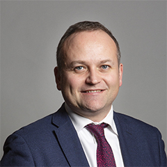 |
| Contact Details | Contact Neil Coyle |
| Political Party | Independent |
What Council is the SE16 6SD Postcode in?
The Local Council for this Postcode is Southwark London Boro Council and the County Council is Greater London Authority Council.
Greater London Authority Council is responsible for providing education, libraries and maintaining highways.
Southwark London Boro Council is responsible for duties such as council tax, rubbish collection, housing, environmental health and planning.
You can visit the website for Southwark London Boro at the following link Southwark London Boro.How much is the Council Tax?
Southwark London Boro Council is responsible for collecting council tax. This will vary depending on which council tax band the property falls within. You can check the council tax band at the gov.uk website.
Once you know the council tax band you can view how much Southwark London Boro charge for that band by visiting the The Council Tax section of their website.
Planning Applications
When moving house to a new post code it is worth checking out what will be built in the neighbourhood.
Few people want to live next door to a building site, have their garden overlooked or have the views from their property ruined.
Visit the local planning department and search for planning applications in this postcode granted within the last three years or still awaiting a decision. This will give an indication of what could still be built.
Where can I find out where the nearest Library to the SE16 6SD Postcode is?
Libraries are the responsibility of Southwark council
Visit the link for more information. Please note that some councils outsource library services to private companies and community groups ran by volunteers.
Libraries - Southwark CouncilPostcodes near the SE16 6SD Postcode
What Popular Supermarkets are near the SE16 6SD Postcode?
| Supermarket | Distance | Directions |
|---|---|---|
| Iceland, Southwark Park Road, Southwark, LONDON, SE16 3RW | 1.79 miles | Directions from SE16 6SD to Iceland |
| Iceland, Watney Market, Tower Hamlets, LONDON, E1 2PP | 1.81 miles | Directions from SE16 6SD to Iceland |
| Waitrose, Canada Square, Tower Hamlets, LONDON, E14 5EW | 1.81 miles | Directions from SE16 6SD to Waitrose |
| Waitrose, Thomas More Street, Tower Hamlets, LONDON, E1W 1YY | 1.93 miles | Directions from SE16 6SD to Waitrose |
| Asda, East Ferry Road, Tower Hamlets, LONDON, E14 3BT | 2.04 miles | Directions from SE16 6SD to Asda |
What Popular Restaurants are near the SE16 6SD Postcode?
| Burger King | Distance | Directions |
|---|---|---|
| Food Court Surrey Quays Centre, Rotherhithe, SE16 7LL | 0.41 miles | Directions from SE16 6SD to Food Court Surrey Quays Centre |
| 90 Whitechapel High Street, London, E1 7RA | 1.66 miles | Directions from SE16 6SD to 90 Whitechapel High Street |
| Fenchurch St Station, London, EC3M 4AJ | 1.79 miles | Directions from SE16 6SD to Fenchurch St Station |
| 46-52 High Street, London, SE15 5DP | 2.25 miles | Directions from SE16 6SD to 46-52 High Street |
| Mcdonald's | Distance | Directions |
|---|---|---|
| McDonald's, Evelyn Street, Lewisham, LONDON, SE8 5DQ | 0.74 miles | Directions from SE16 6SD to McDonald's, Evelyn Street, Lewisham, LONDON, SE8 5DQ |
| McDonald's, The Highway, Tower Hamlets, LONDON, E1W 2BX | 1.06 miles | Directions from SE16 6SD to McDonald's, The Highway, Tower Hamlets, LONDON, E1W 2BX |
| McDonald's, Commercial Road, Tower Hamlets, LONDON, E1 2BT | 1.26 miles | Directions from SE16 6SD to McDonald's, Commercial Road, Tower Hamlets, LONDON, E1 2BT |
| McDonald's, Old Kent Road, Southwark, LONDON, SE1 5BA | 1.59 miles | Directions from SE16 6SD to McDonald's, Old Kent Road, Southwark, LONDON, SE1 5BA |
| Restaurant | Distance | Directions |
|---|---|---|
| KFC, Evelyn Street, Lewisham, LONDON, SE8 5DB | 1.09 miles | Directions from SE16 6SD to KFC Deptford - Evelyn Street |
| KFC, Old Kent Road, Southwark, LONDON, SE15 1JS | 1.53 miles | Directions from SE16 6SD to KFC Old Kent Road |
| KFC, Whitechapel High Street, Tower Hamlets, LONDON, E1 7QX | 1.65 miles | Directions from SE16 6SD to KFC Whitechapel - High Street |
| KFC, Mile End Road, Tower Hamlets, LONDON, E3 4QS | 1.70 miles | Directions from SE16 6SD to KFC London - Mile End Road |
| KFC, Tower Hill Terrace, Tower Hamlets, LONDON, EC3N 4EE | 1.70 miles | Directions from SE16 6SD to KFC London - Tower Hill |