The SL0 9 postcode sector lies where the three counties of Berkshire, Buckinghamshire, and Greater London meet.
Did you know? According to the 2021 Census, the SL0 9 postcode sector is home to a bustling 5,677 residents!
Given that each sector allows for 400 unique postcode combinations. Letters C, I, K, M, O and V are not allowed in the last two letters of a postcode. With 153 postcodes already in use, this leaves 247 units available.
The SL0 9 postal code covers the settlement of IVER .
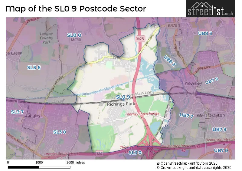
The SL0 9 Postcode shares a border with SL0 0 (IVER HEATH , IVER , FULMER ), SL3 0 (POYLE, COLNBROOK), SL3 6 (Wexham, George Green, FULMER), SL3 8 (SLOUGH, LANGLEY), UB7 7 (WEST DRAYTON , YIEWSLEY ) and UB8 2 (UXBRIDGE , COWLEY ).
The sector is within the post town of IVER.
SL0 9 is a postcode sector within the SL0 postcode district which is within the SL Slough postcode area.
The Royal Mail delivery office for the SL0 9 postal sector is the unknown.
The area of the SL0 9 postcode sector is 3.53 square miles which is 9.15 square kilometres or 2,261.50 square acres.
The SL0 9 postcode sector is crossed by the M4 motorway.
The SL0 9 postcode sector is crossed by the M25 motorway.
Waterways within the SL0 9 postcode sector include the Grand Union Canal - Slough Arm, Wraysbury River, River Colne.

Map of the SL0 9 Postcode Sector
Explore the SL0 9 postcode sector by using our free interactive map.
| S | L | 0 | - | 9 | X | X |
| S | L | 0 | Space | 9 | Letter | Letter |
Official List of Streets
IVER (55 Streets)
Unofficial Streets or Alternative Spellings
IVER,
IVER LANE LANGLEY PARK ROAD MARKET LANE THORNEY MILL ROADIVER
BANGORS CLOSE BANGORS ROAD SOUTH BARNFIELD SWALLOW STREETSLOUGH
PARLAUNT ROADWeather Forecast for SL0 9
Press Button to Show Forecast for Yiewsley
| Time Period | Icon | Description | Temperature | Rain Probability | Wind |
|---|---|---|---|---|---|
| 00:00 to 03:00 | Cloudy | 7.0°C (feels like 5.0°C) | 5.00% | ENE 7 mph | |
| 03:00 to 06:00 | Cloudy | 6.0°C (feels like 3.0°C) | 5.00% | NE 7 mph | |
| 06:00 to 09:00 | Cloudy | 5.0°C (feels like 2.0°C) | 5.00% | NE 7 mph | |
| 09:00 to 12:00 | Cloudy | 8.0°C (feels like 5.0°C) | 5.00% | ENE 7 mph | |
| 12:00 to 15:00 | Cloudy | 10.0°C (feels like 9.0°C) | 8.00% | E 7 mph | |
| 15:00 to 18:00 | Overcast | 11.0°C (feels like 10.0°C) | 16.00% | ENE 4 mph | |
| 18:00 to 21:00 | Cloudy | 10.0°C (feels like 9.0°C) | 13.00% | NE 4 mph | |
| 21:00 to 00:00 | Cloudy | 7.0°C (feels like 5.0°C) | 13.00% | ENE 7 mph |
Press Button to Show Forecast for Yiewsley
| Time Period | Icon | Description | Temperature | Rain Probability | Wind |
|---|---|---|---|---|---|
| 00:00 to 03:00 | Cloudy | 6.0°C (feels like 4.0°C) | 15.00% | ENE 7 mph | |
| 03:00 to 06:00 | Light rain | 5.0°C (feels like 3.0°C) | 47.00% | NE 7 mph | |
| 06:00 to 09:00 | Cloudy | 6.0°C (feels like 3.0°C) | 22.00% | NE 7 mph | |
| 09:00 to 12:00 | Cloudy | 9.0°C (feels like 7.0°C) | 16.00% | ENE 9 mph | |
| 12:00 to 15:00 | Overcast | 12.0°C (feels like 10.0°C) | 17.00% | E 9 mph | |
| 15:00 to 18:00 | Overcast | 12.0°C (feels like 10.0°C) | 23.00% | E 11 mph | |
| 18:00 to 21:00 | Light rain | 11.0°C (feels like 9.0°C) | 53.00% | ENE 9 mph | |
| 21:00 to 00:00 | Light rain | 10.0°C (feels like 7.0°C) | 54.00% | NE 11 mph |
Press Button to Show Forecast for Yiewsley
| Time Period | Icon | Description | Temperature | Rain Probability | Wind |
|---|---|---|---|---|---|
| 00:00 to 03:00 | Heavy rain | 9.0°C (feels like 7.0°C) | 71.00% | NE 11 mph | |
| 03:00 to 06:00 | Heavy rain | 9.0°C (feels like 7.0°C) | 76.00% | ENE 7 mph | |
| 06:00 to 09:00 | Light rain | 9.0°C (feels like 8.0°C) | 52.00% | ESE 7 mph | |
| 09:00 to 12:00 | Heavy rain | 11.0°C (feels like 9.0°C) | 76.00% | ESE 9 mph | |
| 12:00 to 15:00 | Light rain shower (day) | 12.0°C (feels like 10.0°C) | 44.00% | SSE 9 mph | |
| 15:00 to 18:00 | Light rain shower (day) | 14.0°C (feels like 11.0°C) | 39.00% | WSW 11 mph | |
| 18:00 to 21:00 | Light rain shower (day) | 12.0°C (feels like 10.0°C) | 34.00% | W 11 mph | |
| 21:00 to 00:00 | Cloudy | 10.0°C (feels like 8.0°C) | 11.00% | WSW 7 mph |
Schools and Places of Education Within the SL0 9 Postcode Sector
The Iver Village Junior School
Community school
High Street, Iver, Buckinghamshire, SL0 9QA
Head: Miss Jill Digweed
Ofsted Rating: Good
Inspection: 2020-01-29 (1549 days ago)
Website: Visit The Iver Village Junior School Website
Phone: 01753653059
Number of Pupils: 220
House Prices in the SL0 9 Postcode Sector
| Type of Property | 2018 Average | 2018 Sales | 2017 Average | 2017 Sales | 2016 Average | 2016 Sales | 2015 Average | 2015 Sales |
|---|---|---|---|---|---|---|---|---|
| Detached | £894,360 | 22 | £835,135 | 24 | £777,896 | 24 | £696,151 | 24 |
| Semi-Detached | £514,122 | 23 | £571,779 | 14 | £526,239 | 27 | £508,590 | 40 |
| Terraced | £391,280 | 21 | £363,385 | 13 | £374,790 | 24 | £336,108 | 19 |
| Flats | £289,000 | 15 | £283,556 | 9 | £249,318 | 14 | £190,509 | 23 |
Important Postcodes SL0 9 in the Postcode Sector
SL0 9NT is the postcode for Iver Village Infant School, Grange Way
SL0 9NW is the postcode for Iver Village Infant School, West Square
SL0 9QA is the postcode for Iver Village Junior School, High Street
| The SL0 9 Sector is within these Local Authorities |
|
|---|---|
| The SL0 9 Sector is within these Counties |
|
| The SL0 9 Sector is within these Water Company Areas |
|