The SO15 1 postcode sector is within the county of Hampshire.
Did you know? According to the 2021 Census, the SO15 1 postcode sector is home to a bustling 2,945 residents!
Given that each sector allows for 400 unique postcode combinations. Letters C, I, K, M, O and V are not allowed in the last two letters of a postcode. With 84 postcodes already in use, this leaves 316 units available.
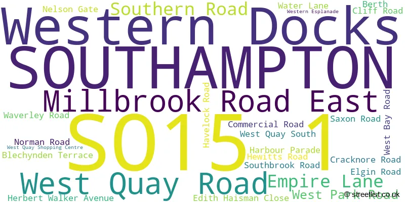
The largest settlements in the SO15 1 postal code are SOUTHAMPTON and Western Docks.
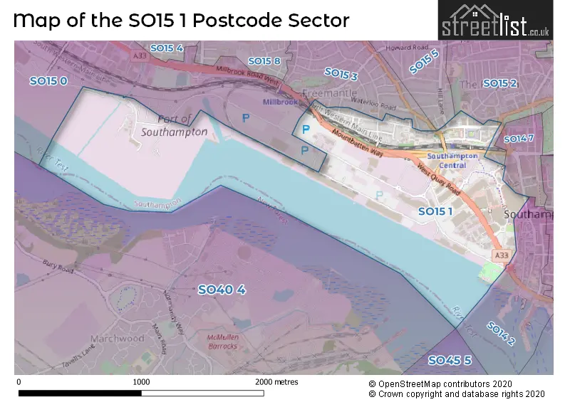
The SO15 1 Postcode shares a border with SO14 2 (SOUTHAMPTON), SO15 2 (SOUTHAMPTON), SO15 0 (SOUTHAMPTON, Western Docks), SO15 5 (SOUTHAMPTON), SO14 7 (SOUTHAMPTON) and SO15 3 (SOUTHAMPTON).
The sector is within the post town of SOUTHAMPTON.
SO15 1 is a postcode sector within the SO15 postcode district which is within the SO Southampton postcode area.
The Royal Mail delivery office for the SO15 1 postal sector is the Shirley (so) Delivery Office.
The area of the SO15 1 postcode sector is 0.87 square miles which is 2.26 square kilometres or 557.87 square acres.
Waterways within the SO15 1 postcode sector include the Tanners Brook.

Map of the SO15 1 Postcode Sector
Explore the SO15 1 postcode sector by using our free interactive map.
| S | O | 1 | 5 | - | 1 | X | X |
| S | O | 1 | 5 | Space | 1 | Letter | Letter |
Official List of Streets
Western Docks (2 Streets)
SOUTHAMPTON (23 Streets)
Unofficial Streets or Alternative Spellings
SOUTHAMPTON
ALMOND ROAD CUMBERLAND PLACE EMPIRE LANE FITZHUGH STREET HILL LANE MORRIS ROAD PARK ROAD PORTLAND TERRACE SHIRLEY ROAD VARNA ROAD BRIDGEWATER COURT CENTRAL STATION BRIDGE EMPTY PARK 1 EMPTY PARK 2 FOURPOSTS HILL KINGSBRIDGE LANE LINKSPAN MAYFLOWER ROUNDABOUT MOUNTBATTEN WAY NELSON HILL PENTALVERS PIRELLI STREET SOLENT ROAD SPA ROAD TRANSFER AREA 2 TRANSFER AREA 3 WEST QUAY ROAD IND ESTATE WYNDHAM PLACEWestern Docks
IMPERIAL WAY WESTERN AVENUEWeather Forecast for SO15 1
Press Button to Show Forecast for Southampton W.C.
| Time Period | Icon | Description | Temperature | Rain Probability | Wind |
|---|---|---|---|---|---|
| 12:00 to 15:00 | Overcast | 9.0°C (feels like 6.0°C) | 15.00% | ENE 9 mph | |
| 15:00 to 18:00 | Overcast | 9.0°C (feels like 7.0°C) | 48.00% | E 9 mph | |
| 18:00 to 21:00 | Light rain | 9.0°C (feels like 7.0°C) | 47.00% | E 7 mph | |
| 21:00 to 00:00 | Light rain | 8.0°C (feels like 6.0°C) | 51.00% | E 9 mph |
Press Button to Show Forecast for Southampton W.C.
| Time Period | Icon | Description | Temperature | Rain Probability | Wind |
|---|---|---|---|---|---|
| 00:00 to 03:00 | Light rain | 7.0°C (feels like 5.0°C) | 57.00% | ENE 9 mph | |
| 03:00 to 06:00 | Light rain | 7.0°C (feels like 4.0°C) | 52.00% | ENE 9 mph | |
| 06:00 to 09:00 | Light rain | 7.0°C (feels like 5.0°C) | 48.00% | NE 9 mph | |
| 09:00 to 12:00 | Cloudy | 9.0°C (feels like 7.0°C) | 10.00% | ENE 9 mph | |
| 12:00 to 15:00 | Cloudy | 12.0°C (feels like 11.0°C) | 13.00% | E 7 mph | |
| 15:00 to 18:00 | Cloudy | 13.0°C (feels like 11.0°C) | 48.00% | E 9 mph | |
| 18:00 to 21:00 | Light rain | 11.0°C (feels like 9.0°C) | 59.00% | NE 9 mph | |
| 21:00 to 00:00 | Heavy rain | 10.0°C (feels like 7.0°C) | 83.00% | NNE 13 mph |
Press Button to Show Forecast for Southampton W.C.
| Time Period | Icon | Description | Temperature | Rain Probability | Wind |
|---|---|---|---|---|---|
| 00:00 to 03:00 | Heavy rain | 9.0°C (feels like 6.0°C) | 85.00% | NNE 13 mph | |
| 03:00 to 06:00 | Heavy rain | 9.0°C (feels like 6.0°C) | 90.00% | NNE 11 mph | |
| 06:00 to 09:00 | Heavy rain | 8.0°C (feels like 5.0°C) | 87.00% | NNW 13 mph | |
| 09:00 to 12:00 | Heavy rain | 8.0°C (feels like 5.0°C) | 74.00% | NW 13 mph | |
| 12:00 to 15:00 | Light rain | 9.0°C (feels like 6.0°C) | 51.00% | WNW 13 mph | |
| 15:00 to 18:00 | Cloudy | 11.0°C (feels like 9.0°C) | 15.00% | W 11 mph | |
| 18:00 to 21:00 | Cloudy | 11.0°C (feels like 9.0°C) | 6.00% | WSW 11 mph | |
| 21:00 to 00:00 | Partly cloudy (night) | 10.0°C (feels like 8.0°C) | 2.00% | WSW 9 mph |
Press Button to Show Forecast for Southampton W.C.
| Time Period | Icon | Description | Temperature | Rain Probability | Wind |
|---|---|---|---|---|---|
| 00:00 to 03:00 | Clear night | 10.0°C (feels like 8.0°C) | 2.00% | WSW 9 mph | |
| 03:00 to 06:00 | Clear night | 8.0°C (feels like 7.0°C) | 1.00% | SW 7 mph | |
| 06:00 to 09:00 | Sunny day | 9.0°C (feels like 7.0°C) | 1.00% | S 7 mph | |
| 09:00 to 12:00 | Cloudy | 11.0°C (feels like 9.0°C) | 5.00% | S 11 mph | |
| 12:00 to 15:00 | Sunny day | 12.0°C (feels like 10.0°C) | 3.00% | S 13 mph | |
| 15:00 to 18:00 | Partly cloudy (day) | 13.0°C (feels like 10.0°C) | 2.00% | S 11 mph | |
| 18:00 to 21:00 | Sunny day | 12.0°C (feels like 10.0°C) | 2.00% | SSE 11 mph | |
| 21:00 to 00:00 | Clear night | 11.0°C (feels like 9.0°C) | 1.00% | SE 11 mph |
Press Button to Show Forecast for Southampton W.C.
| Time Period | Icon | Description | Temperature | Rain Probability | Wind |
|---|---|---|---|---|---|
| 00:00 to 03:00 | Clear night | 11.0°C (feels like 8.0°C) | 2.00% | SE 11 mph | |
| 03:00 to 06:00 | Clear night | 10.0°C (feels like 8.0°C) | 2.00% | SE 11 mph | |
| 06:00 to 09:00 | Sunny day | 11.0°C (feels like 8.0°C) | 3.00% | SE 11 mph | |
| 09:00 to 12:00 | Sunny day | 13.0°C (feels like 10.0°C) | 6.00% | SE 13 mph | |
| 12:00 to 15:00 | Partly cloudy (day) | 14.0°C (feels like 11.0°C) | 9.00% | SE 13 mph | |
| 15:00 to 18:00 | Partly cloudy (day) | 14.0°C (feels like 12.0°C) | 8.00% | SE 11 mph | |
| 18:00 to 21:00 | Sunny day | 14.0°C (feels like 12.0°C) | 9.00% | SE 9 mph | |
| 21:00 to 00:00 | Partly cloudy (night) | 12.0°C (feels like 10.0°C) | 4.00% | SSE 9 mph |
House Prices in the SO15 1 Postcode Sector
| Type of Property | 2018 Average | 2018 Sales | 2017 Average | 2017 Sales | 2016 Average | 2016 Sales | 2015 Average | 2015 Sales |
|---|---|---|---|---|---|---|---|---|
| Detached | £0 | 0 | £0 | 0 | £217,500 | 2 | £0 | 0 |
| Semi-Detached | £215,200 | 5 | £179,500 | 5 | £189,700 | 5 | £179,417 | 6 |
| Terraced | £206,115 | 10 | £211,111 | 9 | £185,785 | 13 | £160,727 | 11 |
| Flats | £146,729 | 26 | £154,803 | 36 | £132,747 | 103 | £120,013 | 27 |
Important Postcodes SO15 1 in the Postcode Sector
SO15 1AN is the postcode for Southampton Central Police Station, Southern Road
SO15 1AP is the postcode for Mayflower Theatre, Empire Lane
SO15 1BA is the postcode for The Quays, 27 Harbour Parade, The Quays Swimming and Diving Complex, 27 Harbour Parade, and The Quays Swimming & Diving Complex, 27 Harbour Parade
SO15 1DP is the postcode for Mayflower A, West Park Road, Mayflower A, University Of Southampton, West Park Road, and MAYFLOWER GYM, SPORT AND WELLBEING EXCLUDING MAYFLOWER A, Mayflower A, West Park Road
SO15 1DQ is the postcode for Mayflower B, West Park Road, and Mayflower B, University Of Southampton, West Park Road
SO15 1DR is the postcode for Mayflower C, University Of Southampton, West Park Road, and Mayflower C, West Park Road
SO15 1EG is the postcode for Spring Place, 105 Commercial Road, and MAIN BUILDING, Spring Place, 105 Commercial Road
SO15 1GW is the postcode for HM REVENUE & CUSTOMS, Valuation Office Agency, Overline House, and Valuation Office Agency, Overline House
SO15 1GX is the postcode for British Transport Police, Grenville House, Nelson Gate, and Southampton City Council, Frobisher House, Nelson Gate
SO15 1YG is the postcode for Southampton City Council, Southbrook Rise, 4-8 Millbrook Road East
| The SO15 1 Sector is within these Local Authorities |
|
|---|---|
| The SO15 1 Sector is within these Counties |
|
| The SO15 1 Sector is within these Water Company Areas |
|