The GU34 3 postcode sector is within the county of Hampshire.
Did you know? According to the 2021 Census, the GU34 3 postcode sector is home to a bustling 2,703 residents!
Given that each sector allows for 400 unique postcode combinations. Letters C, I, K, M, O and V are not allowed in the last two letters of a postcode. With 197 postcodes already in use, this leaves 203 units available.
The largest settlement in the GU34 3 postal code is Selborne followed by Privett, and Lower Farringdon.
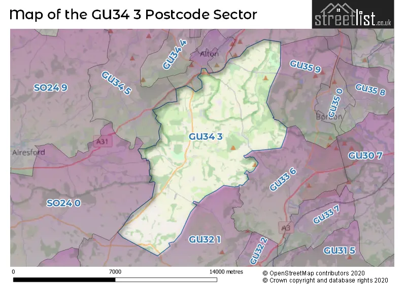
The GU34 3 Postcode shares a border with SO24 0 (Ropley, Cheriton, Bramdean), GU32 1 (East Meon, West Meon, Froxfield), GU33 6 (Greatham, LISS, Hawkley), GU34 4 (Holybourne, Beech, Upper Froyle), GU34 5 (Four Marks, Medstead, Bentworth), GU34 1 (ALTON, Chawton), GU34 2 (ALTON) and GU35 9 (Whitehill, Kingsley, BORDON).
The sector is within the post town of ALTON.
GU34 3 is a postcode sector within the SO24 postcode district which is within the SO Southampton postcode area.
The Royal Mail delivery office for the GU34 3 postal sector is the unknown.
The area of the GU34 3 postcode sector is 30.76 square miles which is 79.68 square kilometres or 19,689.58 square acres.

Map of the GU34 3 Postcode Sector
Explore the GU34 3 postcode sector by using our free interactive map.
| G | U | 3 | 4 | - | 3 | X | X |
| G | U | 3 | 4 | Space | 3 | Letter | Letter |
Official List of Streets
Selborne (22 Streets)
Privett (14 Streets)
East Tisted (6 Streets)
Lower Farringdon (4 Streets)
Colemore (4 Streets)
East Worldham (10 Streets)
Farringdon (5 Streets)
Upper Farringdon (8 Streets)
West Worldham (2 Streets)
Chawton (3 Streets)
Four Marks (2 Streets)
Newton Valence (5 Streets)
ALTON (2 Streets)
Unofficial Streets or Alternative Spellings
Binsted
WYCK LANEBlackmoor
HONEY LANE SOTHERINGTON LANELISS
HAWKLEY ROADALTON
WILSOM ROADChawton
WINCHESTER ROADFour Marks
HAWTHORN ROAD TELEGRAPH LANE THE SHRAVE WEATHERMORE LANE WILLIS LANERopley
LYEWAY LANEFroxfield
CLAYPIT LANEMonkwood
CHARLWOOD LANE HILL FARM ROAD PETERSFIELD ROADWest Tisted
BREWERS LANESchools and Places of Education Within the GU34 3 Postcode Sector
Selborne Church of England Primary School
Voluntary aided school
School Lane, Alton, Hampshire, GU34 3JA
Head: Mrs Lucy Corbishley
Ofsted Rating: Good
Inspection: 2018-06-05 (2179 days ago)
Website: Visit Selborne Church of England Primary School Website
Phone: 01420511213
Number of Pupils: 90
House Prices in the GU34 3 Postcode Sector
| Type of Property | 2018 Average | 2018 Sales | 2017 Average | 2017 Sales | 2016 Average | 2016 Sales | 2015 Average | 2015 Sales |
|---|---|---|---|---|---|---|---|---|
| Detached | £909,170 | 20 | £696,812 | 22 | £674,958 | 12 | £818,663 | 19 |
| Semi-Detached | £426,111 | 9 | £446,000 | 5 | £450,600 | 5 | £475,954 | 8 |
| Terraced | £395,938 | 8 | £345,500 | 2 | £672,500 | 2 | £437,318 | 11 |
| Flats | £0 | 0 | £0 | 0 | £335,000 | 1 | £352,500 | 1 |
Important Postcodes GU34 3 in the Postcode Sector
GU34 3JA is the postcode for Selborne Primary School, Selborne Road
| The GU34 3 Sector is within these Local Authorities |
|
|---|---|
| The GU34 3 Sector is within these Counties |
|
| The GU34 3 Sector is within these Water Company Areas |
|