The SP2 9 postcode sector is within the county of Wiltshire.
Did you know? According to the 2021 Census, the SP2 9 postcode sector is home to a bustling 9,734 residents!
Given that each sector allows for 400 unique postcode combinations. Letters C, I, K, M, O and V are not allowed in the last two letters of a postcode. With 188 postcodes already in use, this leaves 212 units available.
The largest settlements in the SP2 9 postal code are SALISBURY and Quidhampton.
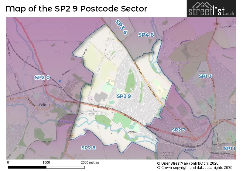
The SP2 9 Postcode shares a border with SP1 3 (SALISBURY, Bishopdown, Stratford Sub Castle), SP2 0 (Wilton, South Newton, Great Wishford), SP2 7 (SALISBURY), SP2 8 (SALISBURY, Netherhampton, West Harnham), SP3 4 (Shrewton, Barford St. Martin, Tilshead) and SP4 6 (Old Sarum, Longhedge, Gomeldon).
The sector is within the post town of SALISBURY.
SP2 9 is a postcode sector within the SP2 postcode district which is within the SP Salisbury postcode area.
The Royal Mail delivery office for the SP2 9 postal sector is the Salisbury Delivery Office.
The area of the SP2 9 postcode sector is 2.16 square miles which is 5.60 square kilometres or 1,383.00 square acres.
The SP2 9 postcode sector is crossed by the A36 Major A road.
Waterways within the SP2 9 postcode sector include the River Nadder, River Avon.

Map of the SP2 9 Postcode Sector
Explore the SP2 9 postcode sector by using our free interactive map.
| S | P | 2 | - | 9 | X | X |
| S | P | 2 | Space | 9 | Letter | Letter |
Official List of Streets
SALISBURY (94 Streets)
Quidhampton (14 Streets)
Unofficial Streets or Alternative Spellings
SALISBURY
AUSTRALIAN AVENUE HARPER ROAD NEW ZEALAND AVENUE ALEXANDRA DRIVE BRICK LANE CARNIVAL HOUSE COLLINGWOOD MEWS EAGLE FIELD FAWCETT DRIVE FESTIVAL CRESCENT FOLLY LANE SAINT ANDREWS ROAD SAINT GREGORYS AVENUE SAINT MICHAELS ROAD SKEW ROAD ST GREGORYS AVENUE THE CROFT WELLINGTON MEWS WHISTLER ROADQuidhampton
WILTON ROADWilton
SALISBURY ROAD THE AVENUENetherhampton
NETHERHAMPTON ROADWeather Forecast for SP2 9
Press Button to Show Forecast for Wilton
| Time Period | Icon | Description | Temperature | Rain Probability | Wind |
|---|---|---|---|---|---|
| 09:00 to 12:00 | Overcast | 8.0°C (feels like 5.0°C) | 12.00% | ENE 11 mph | |
| 12:00 to 15:00 | Overcast | 11.0°C (feels like 9.0°C) | 46.00% | ENE 9 mph | |
| 15:00 to 18:00 | Cloudy | 11.0°C (feels like 9.0°C) | 47.00% | NE 9 mph | |
| 18:00 to 21:00 | Light rain | 10.0°C (feels like 8.0°C) | 54.00% | NE 9 mph | |
| 21:00 to 00:00 | Heavy rain | 8.0°C (feels like 6.0°C) | 80.00% | NNE 11 mph |
Press Button to Show Forecast for Wilton
| Time Period | Icon | Description | Temperature | Rain Probability | Wind |
|---|---|---|---|---|---|
| 00:00 to 03:00 | Heavy rain | 8.0°C (feels like 4.0°C) | 85.00% | NNE 13 mph | |
| 03:00 to 06:00 | Heavy rain | 7.0°C (feels like 4.0°C) | 89.00% | N 11 mph | |
| 06:00 to 09:00 | Heavy rain | 7.0°C (feels like 3.0°C) | 90.00% | NW 11 mph | |
| 09:00 to 12:00 | Heavy rain | 7.0°C (feels like 4.0°C) | 80.00% | NW 11 mph | |
| 12:00 to 15:00 | Light rain | 9.0°C (feels like 7.0°C) | 50.00% | WNW 11 mph | |
| 15:00 to 18:00 | Cloudy | 11.0°C (feels like 9.0°C) | 12.00% | WNW 11 mph | |
| 18:00 to 21:00 | Cloudy | 11.0°C (feels like 9.0°C) | 7.00% | W 7 mph | |
| 21:00 to 00:00 | Clear night | 7.0°C (feels like 5.0°C) | 1.00% | WSW 4 mph |
Press Button to Show Forecast for Wilton
| Time Period | Icon | Description | Temperature | Rain Probability | Wind |
|---|---|---|---|---|---|
| 00:00 to 03:00 | Clear night | 5.0°C (feels like 3.0°C) | 1.00% | SSW 4 mph | |
| 03:00 to 06:00 | Clear night | 4.0°C (feels like 2.0°C) | 1.00% | SSW 4 mph | |
| 06:00 to 09:00 | Sunny day | 6.0°C (feels like 5.0°C) | 2.00% | SSE 4 mph | |
| 09:00 to 12:00 | Cloudy | 12.0°C (feels like 9.0°C) | 5.00% | S 11 mph | |
| 12:00 to 15:00 | Overcast | 13.0°C (feels like 10.0°C) | 9.00% | S 13 mph | |
| 15:00 to 18:00 | Partly cloudy (day) | 13.0°C (feels like 11.0°C) | 3.00% | S 13 mph | |
| 18:00 to 21:00 | Sunny day | 12.0°C (feels like 10.0°C) | 3.00% | SSE 9 mph | |
| 21:00 to 00:00 | Clear night | 9.0°C (feels like 7.0°C) | 3.00% | SE 9 mph |
Press Button to Show Forecast for Wilton
| Time Period | Icon | Description | Temperature | Rain Probability | Wind |
|---|---|---|---|---|---|
| 00:00 to 03:00 | Partly cloudy (night) | 9.0°C (feels like 7.0°C) | 2.00% | SE 9 mph | |
| 03:00 to 06:00 | Clear night | 8.0°C (feels like 6.0°C) | 2.00% | SE 9 mph | |
| 06:00 to 09:00 | Sunny day | 9.0°C (feels like 7.0°C) | 7.00% | SE 9 mph | |
| 09:00 to 12:00 | Sunny day | 13.0°C (feels like 11.0°C) | 10.00% | SE 11 mph | |
| 12:00 to 15:00 | Partly cloudy (day) | 15.0°C (feels like 12.0°C) | 12.00% | SE 13 mph | |
| 15:00 to 18:00 | Partly cloudy (day) | 15.0°C (feels like 12.0°C) | 13.00% | SE 11 mph | |
| 18:00 to 21:00 | Sunny day | 13.0°C (feels like 12.0°C) | 8.00% | SE 7 mph | |
| 21:00 to 00:00 | Cloudy | 11.0°C (feels like 9.0°C) | 6.00% | ESE 7 mph |
Schools and Places of Education Within the SP2 9 Postcode Sector
Bemerton St John Church of England Primary
Academy converter
Lower Road, Salisbury, Wiltshire, SP2 9NW
Head: Mrs Claire Pearce
Ofsted Rating: Good
Inspection: 2023-05-17 (346 days ago)
Website: Visit Bemerton St John Church of England Primary Website
Phone: 01722322848
Number of Pupils: 209
Pembroke Park Primary School
Academy sponsor led
Devizes Road, Salisbury, Wiltshire, SP2 9LY
Head: Mrs Toni Hayzen
Ofsted Rating: Good
Inspection: 2023-12-14 (135 days ago)
Website: Visit Pembroke Park Primary School Website
Phone: 01722324050
Number of Pupils: 238
Sarum Academy
Academy sponsor led
Westwood Road, Salisbury, Wiltshire, SP2 9HS
Head: Mrs Jennifer Moore
Ofsted Rating: Good
Inspection: 2023-02-22 (430 days ago)
Website: Visit Sarum Academy Website
Phone: 01722323431
Number of Pupils: 693
St. Peter's CE Primary Academy
Free schools
Xanten Way, Salisbury, , SP2 9FL
Head: Mr Oliver Martindale
Ofsted Rating: Good
Inspection: 2022-11-16 (528 days ago)
Website: Visit St. Peter's CE Primary Academy Website
Phone: 01722448445
Number of Pupils: 271
Woodlands Primary School
Community school
Winding Way, Salisbury, Wiltshire, SP2 9DY
Head: Mr Matthew Kitley
Ofsted Rating: Good
Inspection: 2023-05-17 (346 days ago)
Website: Visit Woodlands Primary School Website
Phone: 01722335849
Number of Pupils: 206
House Prices in the SP2 9 Postcode Sector
| Type of Property | 2018 Average | 2018 Sales | 2017 Average | 2017 Sales | 2016 Average | 2016 Sales | 2015 Average | 2015 Sales |
|---|---|---|---|---|---|---|---|---|
| Detached | £350,448 | 63 | £389,049 | 34 | £364,403 | 16 | £323,543 | 30 |
| Semi-Detached | £255,111 | 64 | £270,855 | 49 | £234,606 | 32 | £218,672 | 47 |
| Terraced | £229,453 | 38 | £225,872 | 48 | £203,357 | 33 | £193,838 | 48 |
| Flats | £151,995 | 11 | £149,955 | 11 | £134,264 | 11 | £124,167 | 9 |
Important Postcodes SP2 9 in the Postcode Sector
SP2 9DY is the postcode for Woodlands County Primary School, Winding Way
SP2 9HS is the postcode for SARUM ACADEMY 6TH FORM, Sarum Academy, Westwood Road, WYVERN BUILDING, Salisbury High School, Westwood Road, BECKET BUILDING, Salisbury High School, Westwood Road, NEWTON BUILDING, Salisbury High School, Westwood Road, SARUM ACADEMY MAIN (NEW & EXISTING), Sarum Academy, Westwood Road, BECKET SARUM ACADEMY, Sarum Academy, Westwood Road, WYVERN BUILDING SARUM ACADEMY, Sarum Academy, Westwood Road, NEWTON BUILDING SARUM ACADEMY, Sarum Academy, Westwood Road, WESTWOOD SPORTS HALL SARUM ACADEMY, Sarum Academy, Westwood Road, and WESTWOOD SPORTS HALL, Salisbury High School, Westwood Road
SP2 9LY is the postcode for Pembroke Park Primary School, Devizes Road, and Pembroke Park Primary and Pumpkins Nursery, Devizes Road
| The SP2 9 Sector is within these Local Authorities |
|
|---|---|
| The SP2 9 Sector is within these Counties |
|
| The SP2 9 Sector is within these Water Company Areas |
|