The SR3 1 postcode sector is within the county of Tyne & Wear.
Did you know? According to the 2021 Census, the SR3 1 postcode sector is home to a bustling 11,608 residents!
Given that each sector allows for 400 unique postcode combinations. Letters C, I, K, M, O and V are not allowed in the last two letters of a postcode. With 276 postcodes already in use, this leaves 124 units available.
The largest settlements in the SR3 1 postal code are SUNDERLAND and New Silksworth.
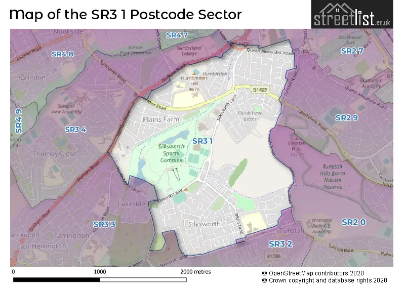
The SR3 1 Postcode shares a border with SR2 7 (SUNDERLAND), SR2 9 (SUNDERLAND, Leechmere Industrial Estate), SR4 7 (SUNDERLAND), SR3 2 (SUNDERLAND, New Silksworth), SR3 3 (SUNDERLAND, East Herrington, Doxford International Business Park), SR3 4 (SUNDERLAND) and SR2 0 (SUNDERLAND, Ryhope).
The sector is within the post town of SUNDERLAND.
SR3 1 is a postcode sector within the SR3 postcode district which is within the SR Sunderland postcode area.
The Royal Mail delivery office for the SR3 1 postal sector is the Sunderland Delivery Office.
The area of the SR3 1 postcode sector is 1.38 square miles which is 3.57 square kilometres or 883.31 square acres.

Map of the SR3 1 Postcode Sector
Explore the SR3 1 postcode sector by using our free interactive map.
| S | R | 3 | - | 1 | X | X |
| S | R | 3 | Space | 1 | Letter | Letter |
Official List of Streets
New Silksworth (14 Streets)
SUNDERLAND (189 Streets)
Unofficial Streets or Alternative Spellings
SUNDERLAND
ALLENDALE ROAD BARNES PARK ROAD CAMBRIDGE ROAD ETTRICK GROVE GRINDON LANE LOUGHBOROUGH AVENUE MEADOWSIDE NORTH MOOR LANE SILKSWORTH TERRACE SPRINGWELL ROAD THE PRECINCT TUNSTALL VILLAS BRIGNALL C CLOTHERSTONE COURT ESSEN WAY GRASSHOLME MEADOWS HIGHSIDE GROVE HORSLEY GROVE NORTH TERRACE PERTH COURT ROUTE 1 SAINT NICHOLAS AVENUE SILKSWORTH CLOSE SPRINGWELL ROAD ST MATTHEWS VIEW TUNSTALL HOPE ROADNew Silksworth
SILKSWORTH ROADEast Herrington
DURHAM ROADWeather Forecast for SR3 1
Press Button to Show Forecast for Sunderland Ski Centre
| Time Period | Icon | Description | Temperature | Rain Probability | Wind |
|---|---|---|---|---|---|
| 21:00 to 00:00 | Clear night | 5.0°C (feels like 4.0°C) | 0.00% | ESE 4 mph |
Press Button to Show Forecast for Sunderland Ski Centre
| Time Period | Icon | Description | Temperature | Rain Probability | Wind |
|---|---|---|---|---|---|
| 00:00 to 03:00 | Clear night | 4.0°C (feels like 3.0°C) | 1.00% | S 2 mph | |
| 03:00 to 06:00 | Partly cloudy (night) | 3.0°C (feels like 2.0°C) | 1.00% | W 2 mph | |
| 06:00 to 09:00 | Partly cloudy (day) | 4.0°C (feels like 3.0°C) | 1.00% | NW 2 mph | |
| 09:00 to 12:00 | Cloudy | 7.0°C (feels like 5.0°C) | 4.00% | E 7 mph | |
| 12:00 to 15:00 | Cloudy | 8.0°C (feels like 6.0°C) | 8.00% | ENE 9 mph | |
| 15:00 to 18:00 | Cloudy | 8.0°C (feels like 6.0°C) | 8.00% | ENE 9 mph | |
| 18:00 to 21:00 | Cloudy | 8.0°C (feels like 5.0°C) | 10.00% | ENE 9 mph | |
| 21:00 to 00:00 | Partly cloudy (night) | 6.0°C (feels like 4.0°C) | 7.00% | ENE 7 mph |
Press Button to Show Forecast for Sunderland Ski Centre
| Time Period | Icon | Description | Temperature | Rain Probability | Wind |
|---|---|---|---|---|---|
| 00:00 to 03:00 | Cloudy | 6.0°C (feels like 4.0°C) | 8.00% | NE 7 mph | |
| 03:00 to 06:00 | Cloudy | 6.0°C (feels like 3.0°C) | 8.00% | NNE 9 mph | |
| 06:00 to 09:00 | Cloudy | 6.0°C (feels like 3.0°C) | 9.00% | N 11 mph | |
| 09:00 to 12:00 | Light rain | 7.0°C (feels like 3.0°C) | 47.00% | N 13 mph | |
| 12:00 to 15:00 | Light rain | 8.0°C (feels like 5.0°C) | 50.00% | NNW 13 mph | |
| 15:00 to 18:00 | Light rain | 9.0°C (feels like 6.0°C) | 45.00% | NNW 11 mph | |
| 18:00 to 21:00 | Cloudy | 9.0°C (feels like 7.0°C) | 11.00% | WNW 7 mph | |
| 21:00 to 00:00 | Clear night | 7.0°C (feels like 5.0°C) | 3.00% | SW 9 mph |
Press Button to Show Forecast for Sunderland Ski Centre
| Time Period | Icon | Description | Temperature | Rain Probability | Wind |
|---|---|---|---|---|---|
| 00:00 to 03:00 | Clear night | 6.0°C (feels like 3.0°C) | 1.00% | SW 9 mph | |
| 03:00 to 06:00 | Clear night | 5.0°C (feels like 2.0°C) | 0.00% | SSW 9 mph | |
| 06:00 to 09:00 | Sunny day | 6.0°C (feels like 3.0°C) | 1.00% | S 9 mph | |
| 09:00 to 12:00 | Partly cloudy (day) | 10.0°C (feels like 8.0°C) | 2.00% | S 11 mph | |
| 12:00 to 15:00 | Cloudy | 13.0°C (feels like 10.0°C) | 5.00% | S 13 mph | |
| 15:00 to 18:00 | Cloudy | 14.0°C (feels like 11.0°C) | 6.00% | S 13 mph | |
| 18:00 to 21:00 | Cloudy | 13.0°C (feels like 10.0°C) | 6.00% | SSE 13 mph | |
| 21:00 to 00:00 | Partly cloudy (night) | 10.0°C (feels like 8.0°C) | 3.00% | SE 11 mph |
Press Button to Show Forecast for Sunderland Ski Centre
| Time Period | Icon | Description | Temperature | Rain Probability | Wind |
|---|---|---|---|---|---|
| 00:00 to 03:00 | Partly cloudy (night) | 9.0°C (feels like 6.0°C) | 1.00% | SSE 11 mph | |
| 03:00 to 06:00 | Clear night | 8.0°C (feels like 5.0°C) | 1.00% | SE 9 mph | |
| 06:00 to 09:00 | Sunny day | 8.0°C (feels like 6.0°C) | 3.00% | SE 9 mph | |
| 09:00 to 12:00 | Partly cloudy (day) | 11.0°C (feels like 8.0°C) | 6.00% | ESE 11 mph | |
| 12:00 to 15:00 | Cloudy | 12.0°C (feels like 9.0°C) | 12.00% | E 11 mph | |
| 15:00 to 18:00 | Cloudy | 12.0°C (feels like 9.0°C) | 14.00% | E 11 mph | |
| 18:00 to 21:00 | Cloudy | 11.0°C (feels like 9.0°C) | 15.00% | E 11 mph | |
| 21:00 to 00:00 | Cloudy | 9.0°C (feels like 8.0°C) | 11.00% | E 7 mph |
Schools and Places of Education Within the SR3 1 Postcode Sector
New Silksworth Academy Infant
Academy sponsor led
Blind Lane, Sunderland, Tyne and Wear, SR3 1AS
Head: Mrs Emma Robins
Ofsted Rating: Good
Inspection: 2019-06-12 (1780 days ago)
Website: Visit New Silksworth Academy Infant Website
Phone: 01915000015
Number of Pupils: 217
New Silksworth Academy Junior
Academy sponsor led
Blind Lane, Sunderland, Tyne and Wear, SR3 1AS
Head: Mrs Emma Robins
Ofsted Rating: Good
Inspection: 2019-06-19 (1773 days ago)
Website: Visit New Silksworth Academy Junior Website
Phone: 01915000015
Number of Pupils: 193
Plains Farm Academy
Academy sponsor led
Tudor Grove, Sunderland, Tyne and Wear, SR3 1SU
Head: Miss Lesley Cassidy
Ofsted Rating: Good
Inspection: 2019-05-08 (1815 days ago)
Website: Visit Plains Farm Academy Website
Phone: 01915203109
Number of Pupils: 190
Thornhill Park School
Other independent special school
Portland Road, Sunderland, , SR3 1SS
Head: Ms Nadine Horton
Ofsted Rating: Good
Inspection: 2023-06-22 (309 days ago)
Website: Visit Thornhill Park School Website
Phone: 01915653965
Number of Pupils: 45
House Prices in the SR3 1 Postcode Sector
| Type of Property | 2018 Average | 2018 Sales | 2017 Average | 2017 Sales | 2016 Average | 2016 Sales | 2015 Average | 2015 Sales |
|---|---|---|---|---|---|---|---|---|
| Detached | £235,494 | 8 | £223,850 | 10 | £264,665 | 10 | £210,431 | 8 |
| Semi-Detached | £143,094 | 61 | £148,645 | 92 | £154,199 | 89 | £150,027 | 96 |
| Terraced | £91,145 | 37 | £93,580 | 46 | £89,005 | 38 | £96,068 | 26 |
| Flats | £105,167 | 3 | £115,750 | 4 | £69,890 | 5 | £75,333 | 3 |
Important Postcodes SR3 1 in the Postcode Sector
SR3 1AS is the postcode for New Silksworth Junior School, Blind Lane, NEW SILKSWORTH INFANT SCHOOL, BLIND LANE, SILKSWORTH, JUNIOR SCHOOL, New Silksworth Academy, Blind Lane, NEW SILKSWORTH JUNIOR SCHOOL, BLIND LANE, SILKSWORTH, New Silksworth Infant Academy, Blind Lane, INFANT SCHOOL, New Silksworth Academy, Blind Lane, New Silksworth Infant School, Blind Lane, and New Silksworth Junior Academy, Blind Lane
SR3 1DZ is the postcode for 17 Tavistock Square
SR3 1PD is the postcode for Silksworth Community Pool & Wellness Centre, Silksworth Lane, SILKSWORTH COMMUNITY SWIMMING POOL, SILKSWORTH LANE, SUNDERLAND, Silksworth Sports Complex and Ski Slope, Silksworth Lane, and Silksworth Community Pool, Tennis and Wellness Centre, Silksworth Lane
SR3 1SS is the postcode for Tudor Grove Centre, Portland Road
SR3 1SU is the postcode for Plains Farm Academy, Tudor Grove
SR3 1TJ is the postcode for Tyne & Wear Fire & Rescue Service, Fire Station, North Moor Road
SR3 1TQ is the postcode for Northumbria Police, Farringdon Hall Police Station, Primate Road
| The SR3 1 Sector is within these Local Authorities |
|
|---|---|
| The SR3 1 Sector is within these Counties |
|
| The SR3 1 Sector is within these Water Company Areas |
|