The SR6 0 postcode sector is within the county of Tyne & Wear.
Did you know? According to the 2021 Census, the SR6 0 postcode sector is home to a bustling 5,007 residents!
Given that each sector allows for 400 unique postcode combinations. Letters C, I, K, M, O and V are not allowed in the last two letters of a postcode. With 139 postcodes already in use, this leaves 261 units available.
The SR6 0 postal code covers the settlement of SUNDERLAND.
The SR6 0 Postcode shares a border with SR6 9 (SUNDERLAND), SR1 1 (SUNDERLAND) and SR5 1 (SUNDERLAND).
The sector is within the post town of SUNDERLAND.
SR6 0 is a postcode sector within the SR6 postcode district which is within the SR Sunderland postcode area.
The Royal Mail delivery office for the SR6 0 postal sector is the Sunderland Delivery Office.
The area of the SR6 0 postcode sector is 0.43 square miles which is 1.12 square kilometres or 275.59 square acres.
Waterways within the SR6 0 postcode sector include the Wear.

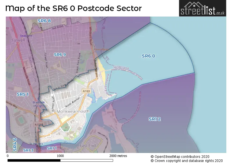
Map of the SR6 0 Postcode Sector
Explore the SR6 0 postcode sector by using our free interactive map.
| S | R | 6 | - | 0 | X | X |
| S | R | 6 | Space | 0 | Letter | Letter |
Official List of Streets
SUNDERLAND (78 Streets)
Unofficial Streets or Alternative Spellings
SUNDERLAND
ASHDALE COURT BURSCOUGH CRESCENT DAME DOROTHY STREET LONSDALE ROAD MIDFIELD DRIVE NEWCASTLE ROAD NORTH BRIDGE STREET PARK PARADE ROKER BATHS ROAD SOUTHWICK ROAD WEARMOUTH STREETWeather Forecast for SR6 0
Press Button to Show Forecast for Roker
| Time Period | Icon | Description | Temperature | Rain Probability | Wind |
|---|---|---|---|---|---|
| 12:00 to 15:00 | Heavy rain | 12.0°C (feels like 9.0°C) | 88.00% | E 13 mph | |
| 15:00 to 18:00 | Cloudy | 12.0°C (feels like 11.0°C) | 10.00% | ESE 9 mph | |
| 18:00 to 21:00 | Cloudy | 13.0°C (feels like 11.0°C) | 10.00% | SE 7 mph | |
| 21:00 to 00:00 | Light rain | 12.0°C (feels like 11.0°C) | 52.00% | SE 7 mph |
Press Button to Show Forecast for Roker
| Time Period | Icon | Description | Temperature | Rain Probability | Wind |
|---|---|---|---|---|---|
| 00:00 to 03:00 | Cloudy | 12.0°C (feels like 11.0°C) | 8.00% | SE 4 mph | |
| 03:00 to 06:00 | Cloudy | 12.0°C (feels like 12.0°C) | 5.00% | SE 2 mph | |
| 06:00 to 09:00 | Cloudy | 12.0°C (feels like 12.0°C) | 6.00% | E 4 mph | |
| 09:00 to 12:00 | Overcast | 12.0°C (feels like 12.0°C) | 9.00% | ENE 4 mph | |
| 12:00 to 15:00 | Overcast | 13.0°C (feels like 12.0°C) | 8.00% | NE 7 mph | |
| 15:00 to 18:00 | Overcast | 13.0°C (feels like 12.0°C) | 8.00% | NE 7 mph | |
| 18:00 to 21:00 | Cloudy | 12.0°C (feels like 11.0°C) | 5.00% | NE 7 mph | |
| 21:00 to 00:00 | Partly cloudy (night) | 12.0°C (feels like 10.0°C) | 1.00% | NNE 7 mph |
Press Button to Show Forecast for Roker
| Time Period | Icon | Description | Temperature | Rain Probability | Wind |
|---|---|---|---|---|---|
| 00:00 to 03:00 | Cloudy | 11.0°C (feels like 10.0°C) | 4.00% | N 4 mph | |
| 03:00 to 06:00 | Cloudy | 11.0°C (feels like 10.0°C) | 6.00% | NNW 7 mph | |
| 06:00 to 09:00 | Partly cloudy (day) | 12.0°C (feels like 11.0°C) | 6.00% | NNW 7 mph | |
| 09:00 to 12:00 | Cloudy | 14.0°C (feels like 13.0°C) | 6.00% | NNE 4 mph | |
| 12:00 to 15:00 | Partly cloudy (day) | 14.0°C (feels like 13.0°C) | 2.00% | NE 9 mph | |
| 15:00 to 18:00 | Sunny day | 14.0°C (feels like 13.0°C) | 1.00% | ENE 9 mph | |
| 18:00 to 21:00 | Sunny day | 13.0°C (feels like 12.0°C) | 1.00% | ENE 9 mph | |
| 21:00 to 00:00 | Clear night | 12.0°C (feels like 10.0°C) | 1.00% | NE 9 mph |
Press Button to Show Forecast for Roker
| Time Period | Icon | Description | Temperature | Rain Probability | Wind |
|---|---|---|---|---|---|
| 00:00 to 03:00 | Clear night | 11.0°C (feels like 10.0°C) | 1.00% | NNE 7 mph | |
| 03:00 to 06:00 | Partly cloudy (night) | 11.0°C (feels like 10.0°C) | 4.00% | N 9 mph | |
| 06:00 to 09:00 | Cloudy | 12.0°C (feels like 11.0°C) | 8.00% | N 9 mph | |
| 09:00 to 12:00 | Cloudy | 13.0°C (feels like 12.0°C) | 9.00% | NNE 9 mph | |
| 12:00 to 15:00 | Partly cloudy (day) | 14.0°C (feels like 12.0°C) | 4.00% | NE 11 mph | |
| 15:00 to 18:00 | Partly cloudy (day) | 14.0°C (feels like 12.0°C) | 5.00% | NE 9 mph | |
| 18:00 to 21:00 | Partly cloudy (day) | 13.0°C (feels like 12.0°C) | 5.00% | NE 9 mph | |
| 21:00 to 00:00 | Partly cloudy (night) | 12.0°C (feels like 11.0°C) | 5.00% | NNE 7 mph |
Press Button to Show Forecast for Roker
| Time Period | Icon | Description | Temperature | Rain Probability | Wind |
|---|---|---|---|---|---|
| 00:00 to 03:00 | Partly cloudy (night) | 12.0°C (feels like 10.0°C) | 7.00% | N 7 mph | |
| 03:00 to 06:00 | Cloudy | 11.0°C (feels like 10.0°C) | 10.00% | N 9 mph | |
| 06:00 to 09:00 | Cloudy | 12.0°C (feels like 10.0°C) | 13.00% | N 11 mph | |
| 09:00 to 12:00 | Partly cloudy (day) | 13.0°C (feels like 11.0°C) | 9.00% | N 11 mph | |
| 12:00 to 15:00 | Sunny day | 14.0°C (feels like 11.0°C) | 6.00% | NNE 11 mph | |
| 15:00 to 18:00 | Partly cloudy (day) | 14.0°C (feels like 11.0°C) | 6.00% | NNE 11 mph | |
| 18:00 to 21:00 | Sunny day | 13.0°C (feels like 11.0°C) | 4.00% | NNE 11 mph | |
| 21:00 to 00:00 | Clear night | 12.0°C (feels like 10.0°C) | 2.00% | NNE 9 mph |
Schools and Places of Education Within the SR6 0 Postcode Sector
Dame Dorothy Primary School
Community school
Dock Street, Sunderland, Tyne and Wear, SR6 0EA
Head: Mr Iain Williamson
Ofsted Rating: Good
Inspection: 2022-02-10 (824 days ago)
Website: Visit Dame Dorothy Primary School Website
Phone: 01912505525
Number of Pupils: 221
House Prices in the SR6 0 Postcode Sector
| Type of Property | 2018 Average | 2018 Sales | 2017 Average | 2017 Sales | 2016 Average | 2016 Sales | 2015 Average | 2015 Sales |
|---|---|---|---|---|---|---|---|---|
| Detached | £203,500 | 2 | £0 | 0 | £300,000 | 1 | £209,250 | 2 |
| Semi-Detached | £153,095 | 10 | £170,389 | 9 | £148,227 | 13 | £145,047 | 15 |
| Terraced | £129,587 | 52 | £136,366 | 51 | £129,641 | 45 | £130,561 | 47 |
| Flats | £116,837 | 24 | £140,974 | 19 | £117,624 | 25 | £115,852 | 31 |
Important Postcodes SR6 0 in the Postcode Sector
SR6 0AB is the postcode for Sunderland Teaching PCT, Monkwearmouth Health Centre, and Monkwearmouth Health Centre, Dundas Street
SR6 0AN is the postcode for University of Sunderland Students Union, Wearbank House, Charles Street, North Shore, University of Sunderland Students Union, University of Sunderland, St. Peters Gate, Charles Street, and St. Peters Sixth Form College, Charles Street
SR6 0DD is the postcode for DAVID GOLDMAN BUILDING, University of Sunderland, Sir Tom Cowie Campus, St. Peters Way, PROSPECT BUILDING, University of Sunderland, Sir Tom Cowie Campus, St. Peters Way, MEDIA CENTRE, University of Sunderland, Sir Tom Cowie Campus, St. Peters Way, and REG VARDY BUSINESS SCHOOL, University of Sunderland, Sir Tom Cowie Campus, St. Peters Way
SR6 0EA is the postcode for DAME DOROTHY PRIMARY SCHOOL, DOCK STREET, MONKWEARMOUTH, and Dame Dorothy Primary School, Dock Street
SR6 0GL is the postcode for National Glass Centre, Liberty Way
SR6 0QQ is the postcode for Saint Bedes Medical Centre, Lower Dundas Street
| The SR6 0 Sector is within these Local Authorities |
|
|---|---|
| The SR6 0 Sector is within these Counties |
|
| The SR6 0 Sector is within these Water Company Areas |
|