The SR6 7 postcode sector is within the county of Tyne & Wear.
Did you know? According to the 2021 Census, the SR6 7 postcode sector is home to a bustling 9,845 residents!
Given that each sector allows for 400 unique postcode combinations. Letters C, I, K, M, O and V are not allowed in the last two letters of a postcode. With 253 postcodes already in use, this leaves 147 units available.
The largest settlement in the SR6 7 postal code is SUNDERLAND followed by Cleadon, and Whitburn.
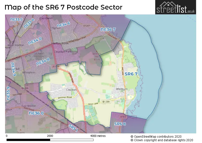
The SR6 7 Postcode shares a border with NE34 7 (SOUTH SHIELDS), NE34 8 (SOUTH SHIELDS), SR6 8 (SUNDERLAND), NE36 0 (EAST BOLDON, West Boldon) and SR5 1 (SUNDERLAND).
The sector is within the post town of SUNDERLAND.
SR6 7 is a postcode sector within the SR6 postcode district which is within the SR Sunderland postcode area.
The Royal Mail delivery office for the SR6 7 postal sector is the Sunderland Delivery Office.
The area of the SR6 7 postcode sector is 4.19 square miles which is 10.84 square kilometres or 2,679.02 square acres.

Map of the SR6 7 Postcode Sector
Explore the SR6 7 postcode sector by using our free interactive map.
| S | R | 6 | - | 7 | X | X |
| S | R | 6 | Space | 7 | Letter | Letter |
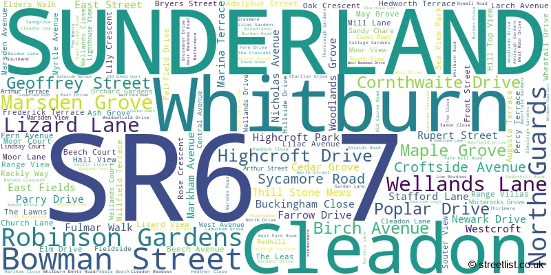
Official List of Streets
SUNDERLAND (111 Streets)
Whitburn (26 Streets)
Cleadon (29 Streets)
Unofficial Streets or Alternative Spellings
SUNDERLAND
SHIELDS ROAD BEDES WAY CHICKS LANE DENE LANE HOLDER HOUSE WAY HOLLY AVENUE KITCHENER ROAD LOW MEADOW SEA LANE TILESHED LANESOUTH SHIELDS,
COAST ROAD LIZARD LANESOUTH SHIELDS
KING GEORGE ROAD SUNDERLAND ROADEAST BOLDON
CLEADON LANE SANDPIPER VIEWWeather Forecast for SR6 7
Press Button to Show Forecast for Marsden (Beach)
| Time Period | Icon | Description | Temperature | Rain Probability | Wind |
|---|---|---|---|---|---|
| 18:00 to 21:00 | Sunny day | 7.0°C (feels like 5.0°C) | 0.00% | ENE 7 mph | |
| 21:00 to 00:00 | Clear night | 6.0°C (feels like 4.0°C) | 0.00% | ESE 4 mph |
Press Button to Show Forecast for Marsden (Beach)
| Time Period | Icon | Description | Temperature | Rain Probability | Wind |
|---|---|---|---|---|---|
| 00:00 to 03:00 | Clear night | 5.0°C (feels like 4.0°C) | 0.00% | ESE 4 mph | |
| 03:00 to 06:00 | Partly cloudy (night) | 5.0°C (feels like 3.0°C) | 1.00% | NE 4 mph | |
| 06:00 to 09:00 | Partly cloudy (day) | 5.0°C (feels like 3.0°C) | 1.00% | N 4 mph | |
| 09:00 to 12:00 | Cloudy | 7.0°C (feels like 5.0°C) | 5.00% | ENE 7 mph | |
| 12:00 to 15:00 | Cloudy | 8.0°C (feels like 5.0°C) | 5.00% | ENE 9 mph | |
| 15:00 to 18:00 | Cloudy | 8.0°C (feels like 5.0°C) | 5.00% | ENE 9 mph | |
| 18:00 to 21:00 | Cloudy | 8.0°C (feels like 5.0°C) | 6.00% | ENE 9 mph | |
| 21:00 to 00:00 | Cloudy | 7.0°C (feels like 5.0°C) | 6.00% | ENE 9 mph |
Press Button to Show Forecast for Marsden (Beach)
| Time Period | Icon | Description | Temperature | Rain Probability | Wind |
|---|---|---|---|---|---|
| 00:00 to 03:00 | Cloudy | 7.0°C (feels like 4.0°C) | 4.00% | NE 9 mph | |
| 03:00 to 06:00 | Cloudy | 7.0°C (feels like 4.0°C) | 8.00% | NNE 13 mph | |
| 06:00 to 09:00 | Cloudy | 7.0°C (feels like 3.0°C) | 7.00% | NNE 16 mph | |
| 09:00 to 12:00 | Light rain | 7.0°C (feels like 3.0°C) | 56.00% | N 18 mph | |
| 12:00 to 15:00 | Heavy rain | 8.0°C (feels like 4.0°C) | 76.00% | NNW 18 mph | |
| 15:00 to 18:00 | Light rain | 8.0°C (feels like 4.0°C) | 50.00% | NNW 16 mph | |
| 18:00 to 21:00 | Partly cloudy (day) | 9.0°C (feels like 7.0°C) | 8.00% | WNW 7 mph | |
| 21:00 to 00:00 | Cloudy | 8.0°C (feels like 5.0°C) | 5.00% | SW 11 mph |
Press Button to Show Forecast for Marsden (Beach)
| Time Period | Icon | Description | Temperature | Rain Probability | Wind |
|---|---|---|---|---|---|
| 00:00 to 03:00 | Clear night | 7.0°C (feels like 4.0°C) | 1.00% | SW 11 mph | |
| 03:00 to 06:00 | Clear night | 6.0°C (feels like 3.0°C) | 1.00% | SSW 11 mph | |
| 06:00 to 09:00 | Partly cloudy (day) | 6.0°C (feels like 3.0°C) | 2.00% | S 11 mph | |
| 09:00 to 12:00 | Partly cloudy (day) | 10.0°C (feels like 7.0°C) | 1.00% | S 13 mph | |
| 12:00 to 15:00 | Cloudy | 12.0°C (feels like 10.0°C) | 5.00% | S 13 mph | |
| 15:00 to 18:00 | Cloudy | 12.0°C (feels like 9.0°C) | 5.00% | SSE 16 mph | |
| 18:00 to 21:00 | Partly cloudy (day) | 12.0°C (feels like 9.0°C) | 3.00% | SSE 16 mph | |
| 21:00 to 00:00 | Partly cloudy (night) | 10.0°C (feels like 7.0°C) | 2.00% | SSE 16 mph |
Press Button to Show Forecast for Marsden (Beach)
| Time Period | Icon | Description | Temperature | Rain Probability | Wind |
|---|---|---|---|---|---|
| 00:00 to 03:00 | Partly cloudy (night) | 9.0°C (feels like 6.0°C) | 1.00% | SSE 13 mph | |
| 03:00 to 06:00 | Clear night | 8.0°C (feels like 5.0°C) | 1.00% | SSE 11 mph | |
| 06:00 to 09:00 | Partly cloudy (day) | 8.0°C (feels like 5.0°C) | 3.00% | SE 11 mph | |
| 09:00 to 12:00 | Cloudy | 10.0°C (feels like 8.0°C) | 8.00% | ESE 11 mph | |
| 12:00 to 15:00 | Cloudy | 11.0°C (feels like 8.0°C) | 10.00% | E 13 mph | |
| 15:00 to 18:00 | Cloudy | 10.0°C (feels like 8.0°C) | 11.00% | E 13 mph | |
| 18:00 to 21:00 | Cloudy | 10.0°C (feels like 7.0°C) | 8.00% | E 13 mph | |
| 21:00 to 00:00 | Overcast | 9.0°C (feels like 7.0°C) | 13.00% | E 11 mph |
Schools and Places of Education Within the SR6 7 Postcode Sector
Marsden Primary School
Community school
Mill Lane, Sunderland, Tyne and Wear, SR6 7HJ
Head: Mrs Caroline Marshall
Ofsted Rating: Good
Inspection: 2023-09-21 (218 days ago)
Website: Visit Marsden Primary School Website
Phone: 01915292040
Number of Pupils: 230
Whitburn Church of England Academy
Academy converter
Whitburn, Sunderland, Tyne and Wear, SR6 7EF
Head: Mr John Crowe
Ofsted Rating: Good
Inspection: 2019-11-13 (1626 days ago)
Website: Visit Whitburn Church of England Academy Website
Phone: 01915293712
Number of Pupils: 1225
Whitburn Village Primary School
Community school
Cleadon Lane, Sunderland, Tyne and Wear, SR6 7NS
Head: Mrs Alison Burden
Ofsted Rating: Good
Inspection: 2020-02-05 (1542 days ago)
Website: Visit Whitburn Village Primary School Website
Phone: 01915293069
Number of Pupils: 235
House Prices in the SR6 7 Postcode Sector
| Type of Property | 2018 Average | 2018 Sales | 2017 Average | 2017 Sales | 2016 Average | 2016 Sales | 2015 Average | 2015 Sales |
|---|---|---|---|---|---|---|---|---|
| Detached | £454,867 | 38 | £401,890 | 43 | £410,649 | 52 | £399,058 | 65 |
| Semi-Detached | £201,538 | 72 | £197,857 | 69 | £186,007 | 62 | £181,515 | 71 |
| Terraced | £191,475 | 20 | £160,419 | 24 | £120,762 | 40 | £138,953 | 33 |
| Flats | £117,367 | 15 | £118,242 | 12 | £157,350 | 10 | £115,630 | 15 |
Important Postcodes SR6 7 in the Postcode Sector
SR6 7EF is the postcode for 6TH FORM, Whitburn Church of England Academy, Whitburn, and Whitburn Church of England Academy, Whitburn
SR6 7HJ is the postcode for Marsden County Junior Mixed School, Mill Lane
SR6 7NS is the postcode for Whitburn Village Primary School, Cleadon Lane, Whitburn, and Whitburn Village Primary School, Cleadon Lane
SR6 7RP is the postcode for Cleadon Village C E Primary School, Boldon Lane
| The SR6 7 Sector is within these Local Authorities |
|
|---|---|
| The SR6 7 Sector is within these Counties |
|
| The SR6 7 Sector is within these Water Company Areas |
|
Tourist Attractions within the SR6 7 Postcode Area
We found 1 visitor attractions within the SR6 postcode area
| Souter Lighthouse and The Leas |
|---|
| Historic Properties |
| Other Historic Property |
| View Souter Lighthouse and The Leas on Google Maps |