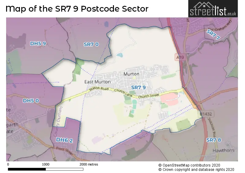
The SR7 9 postcode sector stands on the Durham and Tyne & Wear border.
Did you know? According to the 2021 Census, the SR7 9 postcode sector is home to a bustling 7,257 residents!
Given that each sector allows for 400 unique postcode combinations. Letters C, I, K, M, O and V are not allowed in the last two letters of a postcode. With 228 postcodes already in use, this leaves 172 units available.
The SR7 9 postal code covers the settlement of Murton.
The SR7 9 Postcode shares a border with SR7 0 (SEAHAM, Seaton, Seaham Grange Industrial Estate), SR7 8 (SEAHAM, Dalton-le-Dale, Hawthorn), DH5 0 (Easington Lane, Hetton-le-Hole), DH5 9 (Hetton-le-Hole, East Rainton, HOUGHTON LE SPRING) and DH6 2 (Shotton Colliery, South Hetton, Haswell).
The sector is within the post town of SEAHAM.
SR7 9 is a postcode sector within the SR7 postcode district which is within the SR Sunderland postcode area.
The Royal Mail delivery office for the SR7 9 postal sector is the Seaham Delivery Office.
The area of the SR7 9 postcode sector is 3.40 square miles which is 8.80 square kilometres or 2,173.66 square acres.
The SR7 9 postcode sector is crossed by the A19 Major A road.

Map of the SR7 9 Postcode Sector
Explore the SR7 9 postcode sector by using our free interactive map.
| S | R | 7 | - | 9 | X | X |
| S | R | 7 | Space | 9 | Letter | Letter |
Official List of Streets
Murton (145 Streets)
Unofficial Streets or Alternative Spellings
Weather Forecast for SR7 9
Press Button to Show Forecast for Murton
| Time Period | Icon | Description | Temperature | Rain Probability | Wind |
|---|---|---|---|---|---|
| 15:00 to 18:00 | Cloudy | 7.0°C (feels like 4.0°C) | 3.00% | ENE 9 mph | |
| 18:00 to 21:00 | Sunny day | 6.0°C (feels like 4.0°C) | 0.00% | E 7 mph | |
| 21:00 to 00:00 | Clear night | 3.0°C (feels like 2.0°C) | 0.00% | E 4 mph |
Press Button to Show Forecast for Murton
| Time Period | Icon | Description | Temperature | Rain Probability | Wind |
|---|---|---|---|---|---|
| 00:00 to 03:00 | Clear night | 2.0°C (feels like 1.0°C) | 2.00% | E 2 mph | |
| 03:00 to 06:00 | Partly cloudy (night) | 2.0°C (feels like 1.0°C) | 2.00% | N 2 mph | |
| 06:00 to 09:00 | Cloudy | 4.0°C (feels like 3.0°C) | 3.00% | N 4 mph | |
| 09:00 to 12:00 | Cloudy | 7.0°C (feels like 5.0°C) | 5.00% | ENE 7 mph | |
| 12:00 to 15:00 | Cloudy | 8.0°C (feels like 5.0°C) | 10.00% | ENE 9 mph | |
| 15:00 to 18:00 | Cloudy | 8.0°C (feels like 5.0°C) | 10.00% | ENE 9 mph | |
| 18:00 to 21:00 | Cloudy | 7.0°C (feels like 4.0°C) | 7.00% | ENE 9 mph | |
| 21:00 to 00:00 | Cloudy | 6.0°C (feels like 3.0°C) | 8.00% | ENE 7 mph |
Press Button to Show Forecast for Murton
| Time Period | Icon | Description | Temperature | Rain Probability | Wind |
|---|---|---|---|---|---|
| 00:00 to 03:00 | Cloudy | 5.0°C (feels like 3.0°C) | 7.00% | NE 7 mph | |
| 03:00 to 06:00 | Cloudy | 6.0°C (feels like 2.0°C) | 7.00% | NE 11 mph | |
| 06:00 to 09:00 | Overcast | 6.0°C (feels like 2.0°C) | 14.00% | NNW 13 mph | |
| 09:00 to 12:00 | Light rain | 7.0°C (feels like 3.0°C) | 50.00% | NNW 16 mph | |
| 12:00 to 15:00 | Light rain | 7.0°C (feels like 4.0°C) | 49.00% | NNW 13 mph | |
| 15:00 to 18:00 | Light rain | 8.0°C (feels like 5.0°C) | 44.00% | NNW 13 mph | |
| 18:00 to 21:00 | Sunny day | 9.0°C (feels like 7.0°C) | 8.00% | WNW 7 mph | |
| 21:00 to 00:00 | Clear night | 6.0°C (feels like 3.0°C) | 2.00% | SW 9 mph |
Press Button to Show Forecast for Murton
| Time Period | Icon | Description | Temperature | Rain Probability | Wind |
|---|---|---|---|---|---|
| 00:00 to 03:00 | Clear night | 5.0°C (feels like 2.0°C) | 1.00% | SW 9 mph | |
| 03:00 to 06:00 | Clear night | 4.0°C (feels like 1.0°C) | 1.00% | SSW 9 mph | |
| 06:00 to 09:00 | Sunny day | 6.0°C (feels like 3.0°C) | 1.00% | S 9 mph | |
| 09:00 to 12:00 | Partly cloudy (day) | 10.0°C (feels like 7.0°C) | 2.00% | S 13 mph | |
| 12:00 to 15:00 | Cloudy | 13.0°C (feels like 10.0°C) | 6.00% | S 13 mph | |
| 15:00 to 18:00 | Cloudy | 13.0°C (feels like 10.0°C) | 6.00% | S 13 mph | |
| 18:00 to 21:00 | Partly cloudy (day) | 12.0°C (feels like 9.0°C) | 4.00% | SSE 13 mph | |
| 21:00 to 00:00 | Partly cloudy (night) | 10.0°C (feels like 7.0°C) | 3.00% | SE 13 mph |
Press Button to Show Forecast for Murton
| Time Period | Icon | Description | Temperature | Rain Probability | Wind |
|---|---|---|---|---|---|
| 00:00 to 03:00 | Partly cloudy (night) | 8.0°C (feels like 5.0°C) | 1.00% | SSE 11 mph | |
| 03:00 to 06:00 | Clear night | 7.0°C (feels like 4.0°C) | 1.00% | SE 9 mph | |
| 06:00 to 09:00 | Partly cloudy (day) | 8.0°C (feels like 5.0°C) | 2.00% | SE 9 mph | |
| 09:00 to 12:00 | Cloudy | 11.0°C (feels like 8.0°C) | 8.00% | ESE 11 mph | |
| 12:00 to 15:00 | Cloudy | 12.0°C (feels like 9.0°C) | 12.00% | E 11 mph | |
| 15:00 to 18:00 | Cloudy | 12.0°C (feels like 9.0°C) | 15.00% | E 11 mph | |
| 18:00 to 21:00 | Cloudy | 11.0°C (feels like 9.0°C) | 14.00% | E 11 mph | |
| 21:00 to 00:00 | Cloudy | 9.0°C (feels like 7.0°C) | 10.00% | E 9 mph |
Schools and Places of Education Within the SR7 9 Postcode Sector
Ribbon School
Academy converter
Barnes Road, Seaham, County Durham, SR7 9QR
Head: Mrs Ashleigh Sheridan
Ofsted Rating: Good
Inspection: 2023-01-12 (470 days ago)
Website: Visit Ribbon School Website
Phone: 01915175900
Number of Pupils: 500
St Joseph's Catholic Primary School, Murton
Voluntary aided school
Church Lane, Seaham, County Durham, SR7 9RD
Head: Miss J Jones
Ofsted Rating: Good
Inspection: 2023-05-24 (338 days ago)
Website: Visit St Joseph's Catholic Primary School, Murton Website
Phone: 01915261795
Number of Pupils: 159
House Prices in the SR7 9 Postcode Sector
| Type of Property | 2018 Average | 2018 Sales | 2017 Average | 2017 Sales | 2016 Average | 2016 Sales | 2015 Average | 2015 Sales |
|---|---|---|---|---|---|---|---|---|
| Detached | £203,997 | 16 | £196,583 | 18 | £166,275 | 10 | £200,405 | 11 |
| Semi-Detached | £86,160 | 39 | £94,683 | 37 | £84,718 | 31 | £66,565 | 23 |
| Terraced | £69,242 | 61 | £65,658 | 62 | £58,230 | 52 | £75,730 | 40 |
| Flats | £61,113 | 4 | £56,590 | 5 | £79,167 | 3 | £62,292 | 6 |
Important Postcodes SR7 9 in the Postcode Sector
SR7 9QR is the postcode for RIBBON DAYCARE, Ribbon Academy, Barnes Road, and THE RIBBON, Ribbon Academy, Barnes Road
SR7 9RD is the postcode for St. Josephs RC School, Church Lane
| The SR7 9 Sector is within these Local Authorities |
|
|---|---|
| The SR7 9 Sector is within these Counties |
|
| The SR7 9 Sector is within these Water Company Areas |
|