The SS7 3 postcode sector is within the county of Essex.
Did you know? According to the 2021 Census, the SS7 3 postcode sector is home to a bustling 10,784 residents!
Given that each sector allows for 400 unique postcode combinations. Letters C, I, K, M, O and V are not allowed in the last two letters of a postcode. With 262 postcodes already in use, this leaves 138 units available.
The SS7 3 postal code covers the settlement of BENFLEET.
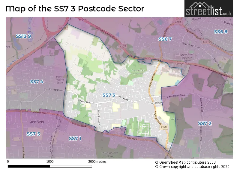
The SS7 3 Postcode shares a border with SS7 1 (BENFLEET), SS7 2 (BENFLEET, Hadleigh), SS6 7 (RAYLEIGH, Brook Road Industrial Estate), SS7 4 (BENFLEET) and SS12 9 (WICKFORD, North Benfleet).
The sector is within the post town of BENFLEET.
SS7 3 is a postcode sector within the SS6 postcode district which is within the SS Southend-on-Sea postcode area.
The Royal Mail delivery office for the SS7 3 postal sector is the unknown.
The area of the SS7 3 postcode sector is 1.96 square miles which is 5.08 square kilometres or 1,255.09 square acres.

Map of the SS7 3 Postcode Sector
Explore the SS7 3 postcode sector by using our free interactive map.
| S | S | 7 | - | 3 | X | X |
| S | S | 7 | Space | 3 | Letter | Letter |
Official List of Streets
BENFLEET (138 Streets)
Unofficial Streets or Alternative Spellings
BENFLEET
ARCADIAN GARDENS BERESFORD GARDENS KILN ROAD KINGSTON ROAD ANGELA MEWS BRADLEY LINK BURCHES ROAD CHURCH VIEW ROAD FIRST AVENUE FOURTH AVENUE GRANDVIEW DRIVE LOVEDAY WAY MAIN ROAD MERRIGOLD CLOSE PHOENIX WAY RAYLEIGH WEIR ROUNDABOUT ROBBINS PATH ROSE STREET SIXTH AVENUE THE OAKS THE POPPIES THIRD AVENUE WESTWOOD LODGE WILLISON WAYRAYLEIGH
ARTERIAL ROAD CLAYDONS LANE RAT LANE RIVENHALLBowers Gifford
LONDON ROADGidea Park
SOUTHEND ARTERIAL ROADWeather Forecast for SS7 3
Press Button to Show Forecast for Thundersley
| Time Period | Icon | Description | Temperature | Rain Probability | Wind |
|---|---|---|---|---|---|
| 18:00 to 21:00 | Sunny day | 13.0°C (feels like 11.0°C) | 0.00% | SSW 9 mph | |
| 21:00 to 00:00 | Clear night | 10.0°C (feels like 8.0°C) | 0.00% | SSE 9 mph |
Press Button to Show Forecast for Thundersley
| Time Period | Icon | Description | Temperature | Rain Probability | Wind |
|---|---|---|---|---|---|
| 00:00 to 03:00 | Clear night | 9.0°C (feels like 7.0°C) | 0.00% | SE 7 mph | |
| 03:00 to 06:00 | Clear night | 8.0°C (feels like 6.0°C) | 0.00% | SE 9 mph | |
| 06:00 to 09:00 | Sunny day | 10.0°C (feels like 8.0°C) | 1.00% | SE 7 mph | |
| 09:00 to 12:00 | Cloudy | 14.0°C (feels like 12.0°C) | 4.00% | SE 9 mph | |
| 12:00 to 15:00 | Cloudy | 15.0°C (feels like 12.0°C) | 9.00% | SSE 11 mph | |
| 15:00 to 18:00 | Cloudy | 14.0°C (feels like 12.0°C) | 12.00% | SSE 11 mph | |
| 18:00 to 21:00 | Cloudy | 13.0°C (feels like 12.0°C) | 16.00% | SE 7 mph | |
| 21:00 to 00:00 | Cloudy | 11.0°C (feels like 10.0°C) | 11.00% | SE 7 mph |
Press Button to Show Forecast for Thundersley
| Time Period | Icon | Description | Temperature | Rain Probability | Wind |
|---|---|---|---|---|---|
| 00:00 to 03:00 | Cloudy | 10.0°C (feels like 9.0°C) | 11.00% | SE 7 mph | |
| 03:00 to 06:00 | Partly cloudy (night) | 9.0°C (feels like 8.0°C) | 10.00% | S 4 mph | |
| 06:00 to 09:00 | Cloudy | 10.0°C (feels like 9.0°C) | 14.00% | N 2 mph | |
| 09:00 to 12:00 | Cloudy | 13.0°C (feels like 13.0°C) | 11.00% | N 4 mph | |
| 12:00 to 15:00 | Cloudy | 15.0°C (feels like 15.0°C) | 11.00% | ESE 4 mph | |
| 15:00 to 18:00 | Cloudy | 15.0°C (feels like 14.0°C) | 12.00% | NE 7 mph | |
| 18:00 to 21:00 | Cloudy | 14.0°C (feels like 13.0°C) | 12.00% | NE 7 mph | |
| 21:00 to 00:00 | Light rain | 12.0°C (feels like 11.0°C) | 41.00% | N 7 mph |
Press Button to Show Forecast for Thundersley
| Time Period | Icon | Description | Temperature | Rain Probability | Wind |
|---|---|---|---|---|---|
| 00:00 to 03:00 | Light rain | 11.0°C (feels like 9.0°C) | 44.00% | NNW 9 mph | |
| 03:00 to 06:00 | Cloudy | 10.0°C (feels like 8.0°C) | 11.00% | WNW 9 mph | |
| 06:00 to 09:00 | Cloudy | 11.0°C (feels like 9.0°C) | 12.00% | WNW 9 mph | |
| 09:00 to 12:00 | Cloudy | 14.0°C (feels like 12.0°C) | 11.00% | WNW 9 mph | |
| 12:00 to 15:00 | Cloudy | 16.0°C (feels like 14.0°C) | 10.00% | NW 9 mph | |
| 15:00 to 18:00 | Partly cloudy (day) | 17.0°C (feels like 15.0°C) | 7.00% | NNW 11 mph | |
| 18:00 to 21:00 | Partly cloudy (day) | 16.0°C (feels like 14.0°C) | 5.00% | NW 9 mph | |
| 21:00 to 00:00 | Cloudy | 12.0°C (feels like 11.0°C) | 6.00% | NW 9 mph |
Schools and Places of Education Within the SS7 3 Postcode Sector
Cedar Hall School
Foundation special school
Hart Road, Benfleet, Essex, SS7 3UQ
Head: Mr Nicholas Maxwell
Ofsted Rating: Good
Inspection: 2023-11-01 (180 days ago)
Website: Visit Cedar Hall School Website
Phone: 01268774723
Number of Pupils: 169
Kingston Primary School
Academy converter
Church Road, Thundersley, Essex, SS7 3HG
Head: Mr Aaron Cross
Ofsted Rating: Outstanding
Inspection: 2023-11-29 (152 days ago)
Website: Visit Kingston Primary School Website
Phone: 01268754137
Number of Pupils: 209
Thundersley Primary School
Academy converter
Hart Road, Benfleet, Essex, SS7 3PT
Head: Miss Emma Dawson
Ofsted Rating: Good
Inspection: 2023-05-24 (341 days ago)
Website: Visit Thundersley Primary School Website
Phone: 01268793251
Number of Pupils: 443
House Prices in the SS7 3 Postcode Sector
| Type of Property | 2018 Average | 2018 Sales | 2017 Average | 2017 Sales | 2016 Average | 2016 Sales | 2015 Average | 2015 Sales |
|---|---|---|---|---|---|---|---|---|
| Detached | £499,650 | 40 | £543,066 | 55 | £435,891 | 55 | £396,674 | 68 |
| Semi-Detached | £313,594 | 91 | £300,111 | 92 | £286,356 | 118 | £249,048 | 113 |
| Terraced | £261,800 | 15 | £265,643 | 14 | £257,150 | 16 | £236,827 | 17 |
| Flats | £204,156 | 16 | £193,139 | 18 | £173,152 | 23 | £150,214 | 14 |
Important Postcodes SS7 3 in the Postcode Sector
SS7 3AT is the postcode for Thundersley Clinic, 8 Kenneth Road
SS7 3HA is the postcode for Royal Mail, Benfleet Delivery Office, Church Road
SS7 3HG is the postcode for Kingston Cp School, Church Road
SS7 3HT is the postcode for MAIN BUILDING, Robert Drake Primary School, Church Road, Robert Drake Primary School, Church Road, and Hesten Lodge, Church Road
SS7 3PT is the postcode for YELLOW BUILDING, Thundersley Primary School, 2 Dark Lane, Thundersley Primary School, 2 Dark Lane, and GREEN BUILDING, Thundersley Primary School, 2 Dark Lane
SS7 3TR is the postcode for Rayleigh Weir Fire Station, Stadium Way
SS7 3UQ is the postcode for Cedar Hall School, Hart Road, and MAIN BUILDING, Cedar Hall School, Hart Road
| The SS7 3 Sector is within these Local Authorities |
|
|---|---|
| The SS7 3 Sector is within these Counties |
|
| The SS7 3 Sector is within these Water Company Areas |
|