The ST14 8 postcode sector stands on the Derbyshire and Staffordshire border.
Did you know? According to the 2021 Census, the ST14 8 postcode sector is home to a bustling 7,369 residents!
Given that each sector allows for 400 unique postcode combinations. Letters C, I, K, M, O and V are not allowed in the last two letters of a postcode. With 273 postcodes already in use, this leaves 127 units available.
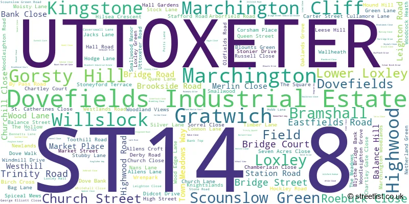
The largest settlement in the ST14 8 postal code is UTTOXETER followed by Marchington, and Kingstone.
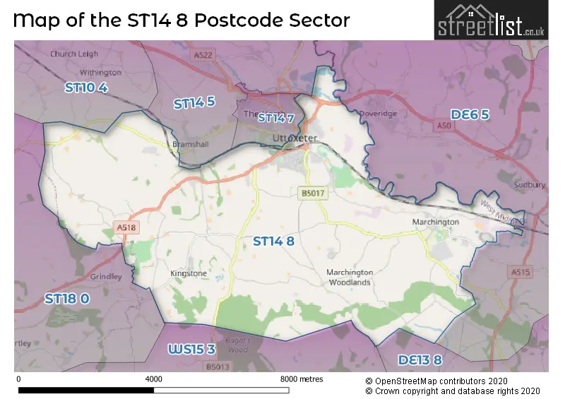
The ST14 8 Postcode shares a border with ST14 7 (UTTOXETER), DE6 5 (Dalbury Lees, Doveridge, Sutton-on-the-Hill), DE13 8 (Barton Under Needwood, Yoxall, Newborough), ST10 4 (Tean, Alton, Leigh), ST14 5 (Rocester, Bramshall, Denstone), ST18 0 (STAFFORD, Great Haywood, Hixon) and WS15 3 (Abbots Bromley, RUGELEY, Hill Ridware).
The sector is within the post town of UTTOXETER.
ST14 8 is a postcode sector within the ST14 postcode district which is within the ST Stoke-on-Trent postcode area.
The Royal Mail delivery office for the ST14 8 postal sector is the Uttoxeter Delivery Office.
The area of the ST14 8 postcode sector is 24.57 square miles which is 63.64 square kilometres or 15,725.17 square acres.
The ST14 8 postcode sector is crossed by the A50 Major A road.


Map of the ST14 8 Postcode Sector
Explore the ST14 8 postcode sector by using our free interactive map.
| S | T | 1 | 4 | - | 8 | X | X |
| S | T | 1 | 4 | Space | 8 | Letter | Letter |
Official List of Streets
Marchington (29 Streets)
UTTOXETER (99 Streets)
Gratwich (4 Streets)
Bramshall (3 Streets)
Kingstone (12 Streets)
Lower Loxley (1 Streets)
Gorsty Hill (5 Streets)
Dovefields Industrial Estate (2 Streets)
Loxley (1 Streets)
Scounslow Green (1 Streets)
Field (1 Streets)
Unofficial Streets or Alternative Spellings
Hoar Cross
THORNEY LANESDraycott-in-the-Clay
STUBBY LANEUTTOXETER
DROVERS CLOSE HIGH STREET OLD SADDLERS YARD SILVER STREETDoveridge
DERBY ROADBramshall
BRAMSHALL ROADHollywood
UTTOXETER ROADWeather Forecast for ST14 8
Press Button to Show Forecast for Uttoxeter Racecourse
| Time Period | Icon | Description | Temperature | Rain Probability | Wind |
|---|---|---|---|---|---|
| 00:00 to 03:00 | Cloudy | 3.0°C (feels like 1.0°C) | 5.00% | NE 4 mph | |
| 03:00 to 06:00 | Cloudy | 2.0°C (feels like 0.0°C) | 4.00% | ENE 4 mph | |
| 06:00 to 09:00 | Partly cloudy (day) | 3.0°C (feels like 0.0°C) | 1.00% | NE 4 mph | |
| 09:00 to 12:00 | Cloudy | 7.0°C (feels like 5.0°C) | 4.00% | ENE 7 mph | |
| 12:00 to 15:00 | Overcast | 9.0°C (feels like 7.0°C) | 10.00% | E 4 mph | |
| 15:00 to 18:00 | Cloudy | 10.0°C (feels like 9.0°C) | 7.00% | NE 4 mph | |
| 18:00 to 21:00 | Cloudy | 8.0°C (feels like 7.0°C) | 10.00% | ENE 7 mph | |
| 21:00 to 00:00 | Cloudy | 5.0°C (feels like 2.0°C) | 9.00% | ENE 7 mph |
Press Button to Show Forecast for Uttoxeter Racecourse
| Time Period | Icon | Description | Temperature | Rain Probability | Wind |
|---|---|---|---|---|---|
| 00:00 to 03:00 | Partly cloudy (night) | 3.0°C (feels like 1.0°C) | 7.00% | ENE 4 mph | |
| 03:00 to 06:00 | Cloudy | 3.0°C (feels like 0.0°C) | 12.00% | NE 4 mph | |
| 06:00 to 09:00 | Cloudy | 4.0°C (feels like 1.0°C) | 11.00% | NE 7 mph | |
| 09:00 to 12:00 | Cloudy | 8.0°C (feels like 5.0°C) | 13.00% | ENE 11 mph | |
| 12:00 to 15:00 | Overcast | 10.0°C (feels like 7.0°C) | 21.00% | ENE 9 mph | |
| 15:00 to 18:00 | Overcast | 10.0°C (feels like 8.0°C) | 21.00% | ENE 11 mph | |
| 18:00 to 21:00 | Cloudy | 9.0°C (feels like 7.0°C) | 18.00% | ENE 11 mph | |
| 21:00 to 00:00 | Cloudy | 7.0°C (feels like 4.0°C) | 21.00% | NE 11 mph |
Press Button to Show Forecast for Uttoxeter Racecourse
| Time Period | Icon | Description | Temperature | Rain Probability | Wind |
|---|---|---|---|---|---|
| 00:00 to 03:00 | Overcast | 7.0°C (feels like 3.0°C) | 23.00% | NE 11 mph | |
| 03:00 to 06:00 | Light rain | 6.0°C (feels like 3.0°C) | 51.00% | NE 13 mph | |
| 06:00 to 09:00 | Heavy rain | 7.0°C (feels like 4.0°C) | 72.00% | NE 13 mph | |
| 09:00 to 12:00 | Heavy rain | 8.0°C (feels like 5.0°C) | 77.00% | NNE 11 mph | |
| 12:00 to 15:00 | Heavy rain | 10.0°C (feels like 7.0°C) | 74.00% | NE 11 mph | |
| 15:00 to 18:00 | Light rain | 10.0°C (feels like 8.0°C) | 56.00% | NNE 11 mph | |
| 18:00 to 21:00 | Light rain shower (day) | 9.0°C (feels like 7.0°C) | 37.00% | NNE 9 mph | |
| 21:00 to 00:00 | Cloudy | 8.0°C (feels like 6.0°C) | 11.00% | S 7 mph |
Schools and Places of Education Within the ST14 8 Postcode Sector
Loxley Hall School
Academy special converter
Stafford Road, Uttoxeter, Staffordshire, ST14 8RS
Head: David Bownds
Ofsted Rating: Good
Inspection: 2023-09-27 (212 days ago)
Website: Visit Loxley Hall School Website
Phone: 01889723050
Number of Pupils: 99
St Peter's CofE (VC) First School
Voluntary controlled school
The Square, Uttoxeter, Staffordshire, ST14 8LH
Head: Mr Jonathan Farrington
Ofsted Rating: Requires improvement
Inspection: 2022-06-23 (673 days ago)
Website: Visit St Peter's CofE (VC) First School Website
Phone: 01283820252
Number of Pupils: 48
Talbot First School
Community school
Church Lane, Uttoxeter, Staffordshire, ST14 8QJ
Head: Mr Jonathan Farrington
Ofsted Rating: Requires improvement
Inspection: 2021-10-07 (932 days ago)
Website: Visit Talbot First School Website
Phone: 01889500273
Number of Pupils: 34
Thomas Alleyne's High School
Academy converter
Dove Bank, Uttoxeter, Staffordshire, ST14 8DU
Head: Mrs Julie Rudge
Ofsted Rating: Good
Inspection: 2019-11-20 (1619 days ago)
Website: Visit Thomas Alleyne's High School Website
Phone: 01889561820
Number of Pupils: 993

House Prices in the ST14 8 Postcode Sector
| Type of Property | 2018 Average | 2018 Sales | 2017 Average | 2017 Sales | 2016 Average | 2016 Sales | 2015 Average | 2015 Sales |
|---|---|---|---|---|---|---|---|---|
| Detached | £307,938 | 53 | £338,744 | 66 | £332,923 | 51 | £327,348 | 58 |
| Semi-Detached | £169,652 | 22 | £171,269 | 24 | £156,084 | 27 | £200,672 | 23 |
| Terraced | £156,084 | 16 | £138,279 | 24 | £173,324 | 27 | £143,224 | 31 |
| Flats | £122,073 | 13 | £111,550 | 11 | £103,000 | 8 | £104,500 | 9 |
Important Postcodes ST14 8 in the Postcode Sector
ST14 8DU is the postcode for HOME ECONOMICS, Staffordshire County Council, Thomas Alleynes High School, Dove Bank, SPORTS BLOCK, Staffordshire County Council, Thomas Alleynes High School, Dove Bank, Staffordshire County Council, Thomas Alleynes High School, Dove Bank, KEELING HOUSE, Staffordshire County Council, Thomas Alleynes High School, Dove Bank, Sports Hall, Thomas Alleynes High School, Dove Bank, and Thomas Alleynes High School, Dove Bank
ST14 8JG is the postcode for Balance Street Health Centre, Balance Street
ST14 8LH is the postcode for Staffordshire County Council, St. Peters C of E First School
ST14 8RS is the postcode for Loxley Hall School, Loxley, and Loxley Hall School, Stafford Road
ST14 8XR is the postcode for B22-TP AMENITIES, H M Prison Dovegate, B11-ENTRY BUILDING, H M Prison Dovegate, B20-VISITS, ADMIN, RECEPTION, H M Prison Dovegate, and H M Prison Dovegate
| The ST14 8 Sector is within these Local Authorities |
|
|---|---|
| The ST14 8 Sector is within these Counties |
|
| The ST14 8 Sector is within these Water Company Areas |
|