The ST19 5 postcode sector is within the county of Staffordshire.
Did you know? According to the 2021 Census, the ST19 5 postcode sector is home to a bustling 9,339 residents!
Given that each sector allows for 400 unique postcode combinations. Letters C, I, K, M, O and V are not allowed in the last two letters of a postcode. With 249 postcodes already in use, this leaves 151 units available.
The largest settlements in the ST19 5 postal code are Penkridge and Gailey.
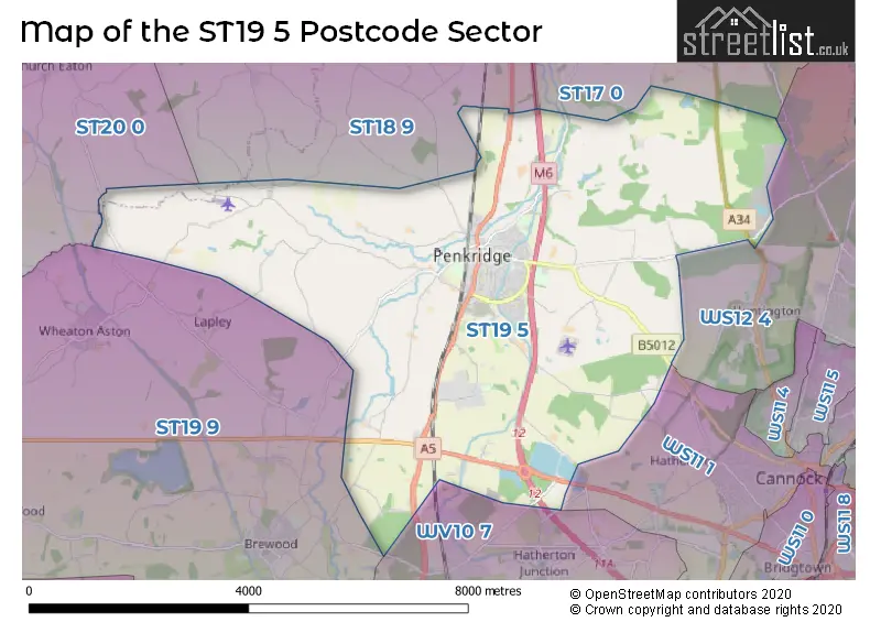
The ST19 5 Postcode shares a border with ST19 9 (Brewood, Wheaton Aston, Bishops Wood), WS11 1 (CANNOCK, Wedges Mills), WV10 7 (Featherstone, Shareshill, Four Ashes), ST17 0 (STAFFORD, Brocton, Acton Trussell), ST18 9 (Haughton, Derrington, Seighford), ST20 0 (Gnosall, Church Eaton, Woodseaves) and WS12 4 (Hednesford, CANNOCK, Huntington).
The sector is within the post town of STAFFORD.
ST19 5 is a postcode sector within the ST19 postcode district which is within the ST Stoke-on-Trent postcode area.
The Royal Mail delivery office for the ST19 5 postal sector is the Stafford Delivery Office.
The area of the ST19 5 postcode sector is 19.83 square miles which is 51.37 square kilometres or 12,694.29 square acres.
The ST19 5 postcode sector is crossed by the A5 Major A road.
The ST19 5 postcode sector is crossed by the A449 Major A road.
The ST19 5 postcode sector is crossed by the M6 motorway.
Waterways within the ST19 5 postcode sector include the Staffordshire and Worcestershire Canal, River Penk.

Map of the ST19 5 Postcode Sector
Explore the ST19 5 postcode sector by using our free interactive map.
| S | T | 1 | 9 | - | 5 | X | X |
| S | T | 1 | 9 | Space | 5 | Letter | Letter |
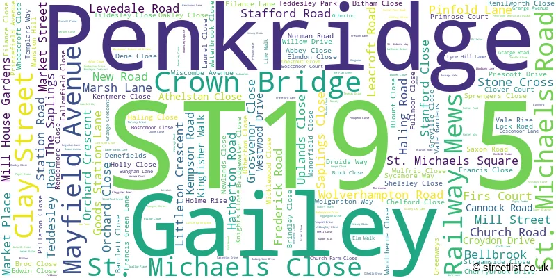
Official List of Streets
Penkridge (191 Streets)
Unofficial Streets or Alternative Spellings
Huntington
STAFFORD ROAD ABLON COURT BRAMDEAN DRIVE BROADHURST GREEN ROAD CLAY GATES ROAD COCK LANE DENEFIELD FAIRFIELD DRIVE FAIRFIELD LANE FULLMOOR LANE FULLMORE CLOSE GAILEY MOTORWAY ISLAND GAILEY ROUNDABOUT LITTLE MARSH PARK LOWER DRAYTON BRIDGE MANSTY LANE MICKLEWOOD LANE MITTON LANE MITTON ROAD MOOR HALL LANE OTHERTON LANE PENKRIDGE BRIDGE PENKRIDGE WHARF PRESTON VALE LANE PRINCEFIELD BRIDGE QUARRY BANK RODBASTON FARM ROAD ROWLEYHILL DRIVE SHEEPWASH LANE SLAB LANE TOWPATH RAMP BESIDE THE BOAT WATERY LANE WHISTON LANE WHITTAMOOR LANEBednall Head
CANNOCK ROADCalf Heath
STABLE LANE WOODLANDS LANEFour Ashes
VICARAGE ROADCoven Heath
STAFFORD ROADDunston
SWAN LANELapley
BICKFORD ROADBradley
SHREDICOTE LANEStandeford
GRAVELLY WAYBlymhill Lawn
WATLING STREETWeather Forecast for ST19 5
Press Button to Show Forecast for Penkridge
| Time Period | Icon | Description | Temperature | Rain Probability | Wind |
|---|---|---|---|---|---|
| 12:00 to 15:00 | Sunny day | 18.0°C (feels like 18.0°C) | 0.00% | WNW 4 mph | |
| 15:00 to 18:00 | Partly cloudy (day) | 20.0°C (feels like 19.0°C) | 1.00% | NW 7 mph | |
| 18:00 to 21:00 | Sunny day | 19.0°C (feels like 19.0°C) | 0.00% | NNW 4 mph | |
| 21:00 to 00:00 | Cloudy | 14.0°C (feels like 13.0°C) | 3.00% | N 4 mph |
Press Button to Show Forecast for Penkridge
| Time Period | Icon | Description | Temperature | Rain Probability | Wind |
|---|---|---|---|---|---|
| 00:00 to 03:00 | Partly cloudy (night) | 12.0°C (feels like 12.0°C) | 0.00% | NNE 2 mph | |
| 03:00 to 06:00 | Cloudy | 11.0°C (feels like 10.0°C) | 4.00% | NNE 2 mph | |
| 06:00 to 09:00 | Cloudy | 13.0°C (feels like 13.0°C) | 4.00% | ENE 2 mph | |
| 09:00 to 12:00 | Cloudy | 19.0°C (feels like 19.0°C) | 3.00% | SSE 2 mph | |
| 12:00 to 15:00 | Cloudy | 21.0°C (feels like 20.0°C) | 4.00% | S 4 mph | |
| 15:00 to 18:00 | Cloudy | 22.0°C (feels like 21.0°C) | 4.00% | S 7 mph | |
| 18:00 to 21:00 | Cloudy | 21.0°C (feels like 21.0°C) | 5.00% | SSE 4 mph | |
| 21:00 to 00:00 | Partly cloudy (night) | 16.0°C (feels like 16.0°C) | 1.00% | SSE 4 mph |
Press Button to Show Forecast for Penkridge
| Time Period | Icon | Description | Temperature | Rain Probability | Wind |
|---|---|---|---|---|---|
| 00:00 to 03:00 | Partly cloudy (night) | 14.0°C (feels like 13.0°C) | 1.00% | SSE 4 mph | |
| 03:00 to 06:00 | Partly cloudy (night) | 12.0°C (feels like 12.0°C) | 0.00% | SSE 4 mph | |
| 06:00 to 09:00 | Partly cloudy (day) | 14.0°C (feels like 14.0°C) | 0.00% | SE 2 mph | |
| 09:00 to 12:00 | Partly cloudy (day) | 18.0°C (feels like 18.0°C) | 1.00% | SE 4 mph | |
| 12:00 to 15:00 | Partly cloudy (day) | 21.0°C (feels like 20.0°C) | 1.00% | SSE 7 mph | |
| 15:00 to 18:00 | Cloudy | 22.0°C (feels like 21.0°C) | 5.00% | SSE 7 mph | |
| 18:00 to 21:00 | Cloudy | 21.0°C (feels like 20.0°C) | 4.00% | SSE 4 mph | |
| 21:00 to 00:00 | Cloudy | 17.0°C (feels like 16.0°C) | 4.00% | SE 7 mph |
Press Button to Show Forecast for Penkridge
| Time Period | Icon | Description | Temperature | Rain Probability | Wind |
|---|---|---|---|---|---|
| 00:00 to 03:00 | Clear night | 15.0°C (feels like 14.0°C) | 0.00% | SE 7 mph | |
| 03:00 to 06:00 | Cloudy | 13.0°C (feels like 12.0°C) | 3.00% | ESE 7 mph | |
| 06:00 to 09:00 | Partly cloudy (day) | 14.0°C (feels like 13.0°C) | 0.00% | ESE 7 mph | |
| 09:00 to 12:00 | Cloudy | 18.0°C (feels like 17.0°C) | 3.00% | ESE 7 mph | |
| 12:00 to 15:00 | Cloudy | 21.0°C (feels like 19.0°C) | 9.00% | SE 9 mph | |
| 15:00 to 18:00 | Cloudy | 21.0°C (feels like 20.0°C) | 17.00% | SSE 9 mph | |
| 18:00 to 21:00 | Light rain shower (day) | 19.0°C (feels like 18.0°C) | 35.00% | S 7 mph | |
| 21:00 to 00:00 | Cloudy | 16.0°C (feels like 15.0°C) | 12.00% | S 7 mph |
Press Button to Show Forecast for Penkridge
| Time Period | Icon | Description | Temperature | Rain Probability | Wind |
|---|---|---|---|---|---|
| 00:00 to 03:00 | Cloudy | 14.0°C (feels like 14.0°C) | 13.00% | S 7 mph | |
| 03:00 to 06:00 | Cloudy | 13.0°C (feels like 12.0°C) | 17.00% | SSW 7 mph | |
| 06:00 to 09:00 | Cloudy | 13.0°C (feels like 12.0°C) | 15.00% | SSW 7 mph | |
| 09:00 to 12:00 | Light rain | 15.0°C (feels like 14.0°C) | 48.00% | S 7 mph | |
| 12:00 to 15:00 | Light rain shower (day) | 17.0°C (feels like 15.0°C) | 42.00% | S 9 mph | |
| 15:00 to 18:00 | Light rain shower (day) | 17.0°C (feels like 15.0°C) | 40.00% | S 9 mph | |
| 18:00 to 21:00 | Heavy rain shower (day) | 15.0°C (feels like 14.0°C) | 65.00% | SSW 9 mph | |
| 21:00 to 00:00 | Light rain | 13.0°C (feels like 12.0°C) | 53.00% | S 9 mph |
Schools and Places of Education Within the ST19 5 Postcode Sector
Marshbrook First School
Academy converter
Teddesley Road, Stafford, Staffordshire, ST19 5BA
Head: Miss Rebecca Nixon
Ofsted Rating: Good
Inspection: 2022-07-06 (673 days ago)
Website: Visit Marshbrook First School Website
Phone: 01785712780
Number of Pupils: 189
Peak Education
Other independent special school
The Old School House, Cannock, Staffordshire, ST19 5PR
Head: Ms Sharon Cliff
Ofsted Rating: Good
Inspection: 2023-04-20 (385 days ago)
Website: Visit Peak Education Website
Phone: 01902790385
Number of Pupils: 8
Penkridge Middle School
Academy converter
Marsh Lane, Stafford, Staffordshire, ST19 5BW
Head: Mr Andrew Grocutt
Ofsted Rating: Good
Inspection: 2022-06-22 (687 days ago)
Website: Visit Penkridge Middle School Website
Phone: 01785413400
Number of Pupils: 492
Princefield First School
Academy converter
Saxon Road, Stafford, Staffordshire, ST19 5EP
Head: Mrs Helen Barron
Ofsted Rating: Good
Inspection: 2022-07-13 (666 days ago)
Website: Visit Princefield First School Website
Phone: 01785714050
Number of Pupils: 215
South Staffordshire College
Further education
Rodbaston Drive, Stafford, , ST19 5PH
Head: Mrs Claire Boliver
Ofsted Rating: Good
Inspection: 2021-11-05 (916 days ago)
Website: Visit South Staffordshire College Website
Phone: 01785712209
Number of Pupils: 0
St Michael's CofE (A) First School
Voluntary aided school
Market Place, Stafford, Staffordshire, ST19 5DJ
Head: Mrs Zoe Cahalan
Ofsted Rating: Good
Inspection: 2022-02-03 (826 days ago)
Website: Visit St Michael's CofE (A) First School Website
Phone: 01785712344
Number of Pupils: 150
The Rural Enterprise Academy
Free schools
Rodbaston Drive, Penkridge, Staffordshire, ST19 5PH
Head: Mrs Alice Corrigan
Ofsted Rating: Good
Inspection: 2018-05-10 (2191 days ago)
Website: Visit The Rural Enterprise Academy Website
Phone: 01785333360
Number of Pupils: 236
Wolgarston High School
Academy converter
Cannock Road, Stafford, Staffordshire, ST19 5RX
Head: Miss Joanne Fairclough
Ofsted Rating: Good
Inspection: 2022-05-05 (735 days ago)
Website: Visit Wolgarston High School Website
Phone: 01785788400
Number of Pupils: 813
House Prices in the ST19 5 Postcode Sector
| Type of Property | 2018 Average | 2018 Sales | 2017 Average | 2017 Sales | 2016 Average | 2016 Sales | 2015 Average | 2015 Sales |
|---|---|---|---|---|---|---|---|---|
| Detached | £306,601 | 57 | £304,056 | 74 | £295,861 | 44 | £297,629 | 46 |
| Semi-Detached | £187,149 | 75 | £176,685 | 86 | £186,567 | 39 | £184,693 | 34 |
| Terraced | £165,060 | 40 | £173,751 | 35 | £171,218 | 19 | £156,448 | 31 |
| Flats | £126,784 | 9 | £97,583 | 3 | £90,000 | 1 | £113,850 | 5 |
Important Postcodes ST19 5 in the Postcode Sector
ST19 5AP is the postcode for Penkridge Medical Practice, Pinfold Lane, and Penkridge Medical Practice, Pinfold Lane, Penkridge
ST19 5BA is the postcode for MARSHBROOK FIRST SCHOOL, TEDDESLEY ROAD, PENKRIDGE, and Marshbrook First School, Teddesley Road
ST19 5BW is the postcode for Penkridge Middle School, Marsh Lane, Penk Valley Academy Trust, Penkridge Middle School, Marsh Lane, and Penkridge County Middle School, Marsh Lane
ST19 5DJ is the postcode for St. Michaels C of E First School, Market Place
ST19 5DT is the postcode for Penkridge Parish Council, Haling Dene Centre, Cannock Road, Penkridge, and Penkridge Parish Council, Haling Dene Centre, Cannock Road
ST19 5EP is the postcode for PRINCEFIELD FIRST SCHOOL, SAXON ROAD, PENKRIDGE, and Princefield First School, Saxon Road
ST19 5LT is the postcode for Penkridge Fire Station, Boscomoor Lane
ST19 5PH is the postcode for NEW TEACHING BUILDING, South Staffordshire College, Rodbaston, The Rural Enterprise Academy, Farm Drive, Main Building, Rodbaston Campus, South Staffordshire College, The Foster Learning Centre, South Staffordshire College, Farm Drive, The Granary (including Carpentry Unit), South Staffordshire College, Farm Drive, MAIN BUILDING MAIN BUILDING, South Staffordshire College, Rodbaston, THE AGRITECH BUILDING, Agristem Academy, Rodbaston, and THE FOSTER LEANING CENTRE, South Staffordshire College, Rodbaston
ST19 5PR is the postcode for Watling House, Watling Street, Gailey, and Watling House, Watling Street
ST19 5RX is the postcode for A Block, Wolgarston High School, Cannock Road, LEISURE CENTRE, Staffordshire County Council, Wolgarston High School, Cannock Road, BLOCK C, Staffordshire County Council, Wolgarston High School, Cannock Road, BLOCK A, Staffordshire County Council, Wolgarston High School, Cannock Road, BLOCK B, Staffordshire County Council, Wolgarston High School, Cannock Road, C Block, Wolgarston High School, Cannock Road, Staffordshire County Council, Wolgarston High School, Cannock Road, and Penkridge Leisure Centre, CANNOCK ROAD
| The ST19 5 Sector is within these Local Authorities |
|
|---|---|
| The ST19 5 Sector is within these Counties |
|
| The ST19 5 Sector is within these Water Company Areas |
|