The ST9 0 postcode sector is within the county of Staffordshire.
Did you know? According to the 2021 Census, the ST9 0 postcode sector is home to a bustling 6,329 residents!
Given that each sector allows for 400 unique postcode combinations. Letters C, I, K, M, O and V are not allowed in the last two letters of a postcode. With 151 postcodes already in use, this leaves 249 units available.
The largest settlements in the ST9 0 postal code are Werrington and Wetley Rocks.
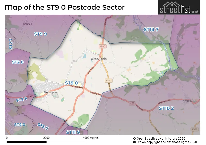
The ST9 0 Postcode shares a border with ST2 8 (STOKE-ON-TRENT), ST11 9 (Blythe Bridge, Forsbrook, Caverswall), ST2 9 (STOKE-ON-TRENT, Ash Bank), ST3 5 (STOKE-ON-TRENT, Weston Coyney), ST9 9 (Endon, Stockton Brook, Longsdon), ST10 2 (Ipstones, Kingsley, Cheadle) and ST13 7 (Cheddleton, LEEK, Bradnop).
The sector is within the post town of STOKE-ON-TRENT.
ST9 0 is a postcode sector within the ST9 postcode district which is within the ST Stoke-on-Trent postcode area.
The Royal Mail delivery office for the ST9 0 postal sector is the Stoke-hanley Delivery Office and Werrington Scale Payment Delivery Office and Wetley Rocks Scale Payment Delivery Office.
The area of the ST9 0 postcode sector is 8.30 square miles which is 21.50 square kilometres or 5,311.72 square acres.
Waterways within the ST9 0 postcode sector include the Caldon Canal.

Map of the ST9 0 Postcode Sector
Explore the ST9 0 postcode sector by using our free interactive map.
| S | T | 9 | - | 0 | X | X |
| S | T | 9 | Space | 0 | Letter | Letter |
Official List of Streets
Wetley Rocks (17 Streets)
Werrington (90 Streets)
Unofficial Streets or Alternative Spellings
Cheadle
LEEK ROAD BANK TOP ROAD CHEDDLETON 18 CHEDDLETON 39 CONSALL 6 DEVILS STAIRCASE DEVILS STAIRCASE PATH DOG DIRT ALLEY DRAW WELL LANE DRAWWELL LANE DRAWWELL PATH FROGHALL TOW PATH GROVE COURT LONGARCES LANE LUZLOW LANE ROWAN ROAD SHIRLEY AVENUE SHUGHBOROUGH CLOSE TICKLE BRIDGE WHITE BAR PATHDilhorne
WINDYCOTE LANEHulme
HULME LANECheddleton
BROOKHOUSE LANE CHEADLE ROAD FOLLY LANEAsh Bank
MEIGH ROADBagnall
THORNEY EDGE ROADWeather Forecast for ST9 0
Press Button to Show Forecast for Bucknall
| Time Period | Icon | Description | Temperature | Rain Probability | Wind |
|---|---|---|---|---|---|
| 12:00 to 15:00 | Cloudy | 7.0°C (feels like 4.0°C) | 42.00% | E 9 mph | |
| 15:00 to 18:00 | Cloudy | 8.0°C (feels like 6.0°C) | 12.00% | E 7 mph | |
| 18:00 to 21:00 | Cloudy | 7.0°C (feels like 5.0°C) | 6.00% | E 9 mph | |
| 21:00 to 00:00 | Cloudy | 5.0°C (feels like 2.0°C) | 6.00% | E 9 mph |
Press Button to Show Forecast for Bucknall
| Time Period | Icon | Description | Temperature | Rain Probability | Wind |
|---|---|---|---|---|---|
| 00:00 to 03:00 | Cloudy | 5.0°C (feels like 1.0°C) | 7.00% | ENE 9 mph | |
| 03:00 to 06:00 | Cloudy | 4.0°C (feels like 1.0°C) | 6.00% | ENE 9 mph | |
| 06:00 to 09:00 | Cloudy | 4.0°C (feels like 1.0°C) | 7.00% | ENE 9 mph | |
| 09:00 to 12:00 | Cloudy | 7.0°C (feels like 4.0°C) | 9.00% | ENE 11 mph | |
| 12:00 to 15:00 | Overcast | 8.0°C (feels like 6.0°C) | 17.00% | ENE 11 mph | |
| 15:00 to 18:00 | Overcast | 8.0°C (feels like 6.0°C) | 16.00% | ENE 11 mph | |
| 18:00 to 21:00 | Cloudy | 8.0°C (feels like 5.0°C) | 8.00% | ENE 11 mph | |
| 21:00 to 00:00 | Cloudy | 6.0°C (feels like 3.0°C) | 5.00% | NE 9 mph |
Press Button to Show Forecast for Bucknall
| Time Period | Icon | Description | Temperature | Rain Probability | Wind |
|---|---|---|---|---|---|
| 00:00 to 03:00 | Cloudy | 5.0°C (feels like 2.0°C) | 5.00% | NNE 9 mph | |
| 03:00 to 06:00 | Cloudy | 5.0°C (feels like 2.0°C) | 18.00% | N 9 mph | |
| 06:00 to 09:00 | Light rain | 5.0°C (feels like 2.0°C) | 54.00% | N 9 mph | |
| 09:00 to 12:00 | Light rain | 6.0°C (feels like 3.0°C) | 53.00% | NNW 11 mph | |
| 12:00 to 15:00 | Overcast | 8.0°C (feels like 5.0°C) | 21.00% | NW 11 mph | |
| 15:00 to 18:00 | Cloudy | 10.0°C (feels like 7.0°C) | 13.00% | WNW 11 mph | |
| 18:00 to 21:00 | Sunny day | 9.0°C (feels like 7.0°C) | 4.00% | WNW 9 mph | |
| 21:00 to 00:00 | Clear night | 6.0°C (feels like 4.0°C) | 1.00% | WSW 7 mph |
Press Button to Show Forecast for Bucknall
| Time Period | Icon | Description | Temperature | Rain Probability | Wind |
|---|---|---|---|---|---|
| 00:00 to 03:00 | Clear night | 5.0°C (feels like 2.0°C) | 2.00% | SSW 7 mph | |
| 03:00 to 06:00 | Clear night | 4.0°C (feels like 1.0°C) | 1.00% | S 7 mph | |
| 06:00 to 09:00 | Sunny day | 5.0°C (feels like 2.0°C) | 1.00% | SSE 9 mph | |
| 09:00 to 12:00 | Partly cloudy (day) | 10.0°C (feels like 7.0°C) | 2.00% | S 13 mph | |
| 12:00 to 15:00 | Overcast | 12.0°C (feels like 9.0°C) | 10.00% | S 13 mph | |
| 15:00 to 18:00 | Cloudy | 13.0°C (feels like 10.0°C) | 7.00% | S 13 mph | |
| 18:00 to 21:00 | Cloudy | 12.0°C (feels like 10.0°C) | 6.00% | S 11 mph | |
| 21:00 to 00:00 | Clear night | 10.0°C (feels like 7.0°C) | 2.00% | SSE 11 mph |
Press Button to Show Forecast for Bucknall
| Time Period | Icon | Description | Temperature | Rain Probability | Wind |
|---|---|---|---|---|---|
| 00:00 to 03:00 | Clear night | 8.0°C (feels like 6.0°C) | 3.00% | SE 9 mph | |
| 03:00 to 06:00 | Partly cloudy (night) | 7.0°C (feels like 4.0°C) | 2.00% | ESE 11 mph | |
| 06:00 to 09:00 | Sunny day | 8.0°C (feels like 5.0°C) | 2.00% | ESE 11 mph | |
| 09:00 to 12:00 | Partly cloudy (day) | 12.0°C (feels like 9.0°C) | 5.00% | ESE 13 mph | |
| 12:00 to 15:00 | Cloudy | 14.0°C (feels like 12.0°C) | 11.00% | SE 13 mph | |
| 15:00 to 18:00 | Cloudy | 15.0°C (feels like 13.0°C) | 13.00% | SE 11 mph | |
| 18:00 to 21:00 | Partly cloudy (day) | 14.0°C (feels like 12.0°C) | 8.00% | ESE 9 mph | |
| 21:00 to 00:00 | Partly cloudy (night) | 11.0°C (feels like 10.0°C) | 4.00% | E 9 mph |
Schools and Places of Education Within the ST9 0 Postcode Sector
Cicely Haughton School
Academy special converter
Westwood Manor, Stoke-on-Trent, Staffordshire, ST9 0BX
Head: Mrs Janey Hancock
Ofsted Rating: Outstanding
Inspection: 2023-05-11 (351 days ago)
Website: Visit Cicely Haughton School Website
Phone: 01782550202
Number of Pupils: 58
St John's CofE Primary School
Academy converter
Mill Lane, Wetley Rocks, Stoke-on-Trent, Staffordshire, ST9 0BN
Head: Mrs Sarah Stone
Ofsted Rating: Good
Inspection: 2023-11-29 (149 days ago)
Website: Visit St John's CofE Primary School Website
Phone: 01782550309
Number of Pupils: 179
House Prices in the ST9 0 Postcode Sector
| Type of Property | 2018 Average | 2018 Sales | 2017 Average | 2017 Sales | 2016 Average | 2016 Sales | 2015 Average | 2015 Sales |
|---|---|---|---|---|---|---|---|---|
| Detached | £232,140 | 30 | £246,053 | 53 | £208,343 | 50 | £200,774 | 56 |
| Semi-Detached | £154,227 | 56 | £148,180 | 55 | £139,757 | 53 | £135,129 | 42 |
| Terraced | £226,375 | 4 | £141,761 | 9 | £178,343 | 7 | £166,000 | 5 |
| Flats | £0 | 0 | £123,500 | 1 | £0 | 0 | £0 | 0 |
Important Postcodes ST9 0 in the Postcode Sector
ST9 0BN is the postcode for St Johns Church Of England Primary School, Mill Lane, and Staffordshire County Council, St. Johns C of E Cp School, Mill Lane
ST9 0BX is the postcode for CICELY HAUGHTON SPECIAL SCHOOL, WESTWOOD MANOR, WESTWOOD, and Staffordshire County Council, Cicely Haughton Special School Westwood Manor,
ST9 0DX is the postcode for H M Youth Custody Centre, Werrington
ST9 0HP is the postcode for MOORSIDE HIGH SCHOOL, CELLARHEAD ROAD, CELLARHEAD, MOORSIDE HIGH SCHOOL, CELLARHEAD ROAD, and Staffordshire County Council, Moorside High School, Cellarhead Road
ST9 0JS is the postcode for Werrington Village Surgery, Ash Bank Road
ST9 0JU is the postcode for Werrington Primary School, Washerwall Lane, Werrington, and Werrington Primary School, Washerwall Lane
| The ST9 0 Sector is within these Local Authorities |
|
|---|---|
| The ST9 0 Sector is within these Counties |
|
| The ST9 0 Sector is within these Water Company Areas |
|