The SW5 0 postcode sector is within the county of Greater London.
Did you know? According to the 2021 Census, the SW5 0 postcode sector is home to a bustling 6,282 residents!
Given that each sector allows for 400 unique postcode combinations. Letters C, I, K, M, O and V are not allowed in the last two letters of a postcode. With 149 postcodes already in use, this leaves 251 units available.
The SW5 0 postal code covers the settlement of LONDON .
The SW5 0 Postcode shares a border with SW5 9 (LONDON ), SW7 3 (LONDON ), SW7 4 (LONDON ), SW10 9 (LONDON ), W8 5 (LONDON ) and W8 6 (LONDON ).
The sector is within the post town of LONDON.
SW5 0 is a postcode sector within the SW5 postcode district which is within the SW South West London postcode area.
The Royal Mail delivery office for the SW5 0 postal sector is the Earls Court Sdelivery Office.
The area of the SW5 0 postcode sector is 0.13 square miles which is 0.33 square kilometres or 80.42 square acres.

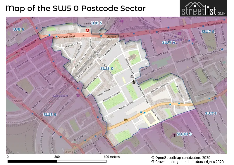
Map of the SW5 0 Postcode Sector
Explore the SW5 0 postcode sector by using our free interactive map.
| S | W | 5 | - | 0 | X | X |
| S | W | 5 | Space | 0 | Letter | Letter |
Official List of Streets
Kensington and Chelsea (34 Streets)
Unofficial Streets or Alternative Spellings
Kensington and Chelsea
COLBECK MEWS COURTFIELD ROAD CRESSWELL PLACE DRAYTON GARDENS HARRINGTON GARDENS LEXHAM GARDENS MARLOES ROAD PENNANT MEWS THE BOLTONS EARLS COURT ROADHammersmith and Fulham
WEST CROMWELL ROADWeather Forecast for SW5 0
Press Button to Show Forecast for Earl's Court Youth Hostel
| Time Period | Icon | Description | Temperature | Rain Probability | Wind |
|---|---|---|---|---|---|
| 03:00 to 06:00 | Cloudy | 6.0°C (feels like 4.0°C) | 5.00% | NE 7 mph | |
| 06:00 to 09:00 | Cloudy | 5.0°C (feels like 3.0°C) | 5.00% | NE 7 mph | |
| 09:00 to 12:00 | Cloudy | 8.0°C (feels like 6.0°C) | 5.00% | ENE 7 mph | |
| 12:00 to 15:00 | Cloudy | 11.0°C (feels like 9.0°C) | 10.00% | ENE 7 mph | |
| 15:00 to 18:00 | Cloudy | 11.0°C (feels like 10.0°C) | 13.00% | ENE 7 mph | |
| 18:00 to 21:00 | Cloudy | 11.0°C (feels like 9.0°C) | 13.00% | NE 7 mph | |
| 21:00 to 00:00 | Cloudy | 8.0°C (feels like 6.0°C) | 11.00% | E 7 mph |
Press Button to Show Forecast for Earl's Court Youth Hostel
| Time Period | Icon | Description | Temperature | Rain Probability | Wind |
|---|---|---|---|---|---|
| 00:00 to 03:00 | Cloudy | 6.0°C (feels like 4.0°C) | 17.00% | ENE 7 mph | |
| 03:00 to 06:00 | Cloudy | 5.0°C (feels like 3.0°C) | 18.00% | NE 7 mph | |
| 06:00 to 09:00 | Cloudy | 6.0°C (feels like 4.0°C) | 20.00% | ENE 7 mph | |
| 09:00 to 12:00 | Cloudy | 10.0°C (feels like 8.0°C) | 15.00% | ENE 9 mph | |
| 12:00 to 15:00 | Overcast | 12.0°C (feels like 10.0°C) | 17.00% | E 9 mph | |
| 15:00 to 18:00 | Light rain | 13.0°C (feels like 11.0°C) | 52.00% | E 11 mph | |
| 18:00 to 21:00 | Light rain | 11.0°C (feels like 9.0°C) | 54.00% | ENE 9 mph | |
| 21:00 to 00:00 | Light rain | 10.0°C (feels like 8.0°C) | 54.00% | NE 11 mph |
Press Button to Show Forecast for Earl's Court Youth Hostel
| Time Period | Icon | Description | Temperature | Rain Probability | Wind |
|---|---|---|---|---|---|
| 00:00 to 03:00 | Heavy rain | 10.0°C (feels like 7.0°C) | 74.00% | NE 9 mph | |
| 03:00 to 06:00 | Light rain shower (night) | 10.0°C (feels like 8.0°C) | 45.00% | ESE 9 mph | |
| 06:00 to 09:00 | Light rain | 10.0°C (feels like 8.0°C) | 52.00% | SE 7 mph | |
| 09:00 to 12:00 | Heavy rain shower (day) | 11.0°C (feels like 9.0°C) | 61.00% | SE 9 mph | |
| 12:00 to 15:00 | Heavy rain shower (day) | 12.0°C (feels like 11.0°C) | 61.00% | S 9 mph | |
| 15:00 to 18:00 | Light rain shower (day) | 14.0°C (feels like 12.0°C) | 37.00% | SSW 11 mph | |
| 18:00 to 21:00 | Partly cloudy (day) | 12.0°C (feels like 10.0°C) | 15.00% | SW 11 mph | |
| 21:00 to 00:00 | Partly cloudy (night) | 11.0°C (feels like 9.0°C) | 8.00% | SW 7 mph |
Schools and Places of Education Within the SW5 0 Postcode Sector
Bousfield Primary School
Community school
South Bolton Gardens, London, , SW5 0DJ
Head: Mrs Jane Griffiths
Ofsted Rating: Good
Inspection: 2022-09-29 (575 days ago)
Website: Visit Bousfield Primary School Website
Phone: 02073736544
Number of Pupils: 431
House Prices in the SW5 0 Postcode Sector
| Type of Property | 2018 Average | 2018 Sales | 2017 Average | 2017 Sales | 2016 Average | 2016 Sales | 2015 Average | 2015 Sales |
|---|---|---|---|---|---|---|---|---|
| Detached | £0 | 0 | £1,440,000 | 1 | £0 | 0 | £495,000 | 1 |
| Semi-Detached | £0 | 0 | £0 | 0 | £0 | 0 | £3,000,000 | 1 |
| Terraced | £2,660,000 | 7 | £2,897,500 | 8 | £2,863,214 | 7 | £2,867,050 | 10 |
| Flats | £1,445,108 | 60 | £1,492,972 | 74 | £1,463,312 | 80 | £1,454,351 | 127 |
Important Postcodes SW5 0 in the Postcode Sector
SW5 0BS is the postcode for Royal Borough of Kensington & Chelsea, Brompton Library, 210 Old Brompton Road
SW5 0DJ is the postcode for Bousfield Primary School, South Bolton Gardens
SW5 0PT is the postcode for Earls Court Health Centre, 2b Hogarth Road
SW5 0RR is the postcode for Metropolitan Police, 2-4 Kenway Road
| The SW5 0 Sector is within these Local Authorities |
|
|---|---|
| The SW5 0 Sector is within these Counties |
|
| The SW5 0 Sector is within these Water Company Areas |
|