E Postcode District
- E1: Eastern head district
- E1W: Wapping district
- E2: Bethnal Green district
- E3: Bow district
- E4: Chingford district
- E5: Clapton district
- E6: East Ham district
- E7: Forest Gate district
- E8: Hackney district
- E9: Homerton district
- E10: Leyton district
- E11: Leytonstone district
- E12: Manor Park distric
- E13: Plaistow district
- E14: Poplar district
- E15: Stratford district
- E16: Victoria Docks district
- E17: Walthamstow district
- E18: Woodford and South Woodford district
- E19: Walford district (fictional used for EastEnders)
- E20: Olympic Park district (introduced for 2012 Olympics)
EC Postcode District
- EC1A: St Bartholomew's Hospital
- EC1M: Clerkenwell
- EC1N: Hatton Gardens
- EC1R: Finsbury West
- EC1V: Finsbury East
- EC1Y: St Luke's
- EC2A: Shoreditch
- EC2M: Broadgate
- EC2N: Old Broad Street
- EC2R: Bank of England
- EC2V: Guildhall
- EC2Y: Barbican
- EC3A: St Mary Axe
- EC3M: Fenchurch Street
- EC3N: Tower Hill
- EC3R: Monument
- EC3V: Cornhill
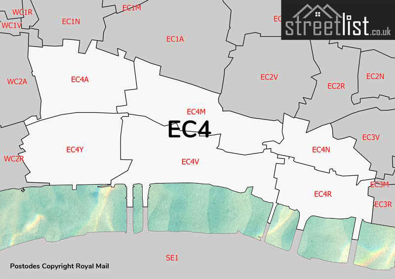
- EC4A: Fetter Lane
- EC4M: St Paul's
- EC4N: Mansion House
- EC4R: Cannon Street
- EC4V: Blackfriars
- EC4Y: Temple
N Postcode District
- N1: Northern head district
- N1C: Kings Cross Central
- N2: East Finchley
- N3: Finchley
- N4: Finsbury Park
- N5: Highbury district
- N6: Highgate district
- N7: Holloway district
- N8: Hornsey district
- N9: Lower Edmonton district
- N10: Muswell Hill district
- N11: New Southgate district
- N12: North Finchley district
- N13: Palmers Green district
- N14: Southgate district
- N15: South Tottenham district
- N16: Stoke Newington district
- N17: Tottenham district
- N18: Upper Edmonton district
- N19: Upper Holloway district:
- N20: Whetstone district
- N21: Winchmore Hill district
- N22: Wood Green district
NW Postcode District
- NW1: North Western head district
- NW2: Cricklewood district
- NW3: Hampstead distric
- NW4: Hendon district
- NW5: Kentish Town district
- NW6: Kilburn district
- NW7: Mill Hill district
- NW8: St John's Wood district
- NW9: The Hyde district
- NW10: Willesden district
- NW11: Golders Green district
SE Postcode District
- S1: South Eastern head district
- S2: Abbey Wood district
- S3: Blackheath district
- S4: Brockley district
- S5: Camberwell district
- S6: Catford district
- S7: Charlton district
- S8: Deptford district
- S9: Eltham district
- S10: Greenwich district
- S11: Kennington district
- S12: Lee district
- S13: Lewisham district
- S14: New Cross district
- S15: Peckham district
- S16: Rotherhithe district
- S17: Walworth district
- S18: Woolwich district
- S19: Norwood district
- S20: Anerley district
- S21: Dulwich district
- S22: East Dulwich district
- S23: Forest Hill district
- S24: Herne Hill
- S25: South Norwood district
- S26: Sydenham district
- S27: West Norwood district
- S28: Thamesmead district
SW Postcode District
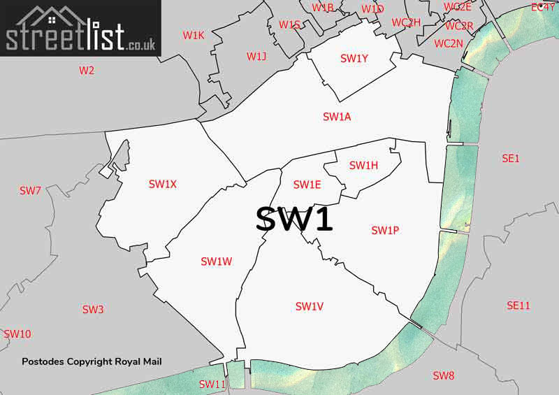
- SW1A: Whitehall
- SW1E: Northern 'Victoria
- SW1H: St James's Park
- SW1P: Parliament Square
- SW1V: Pimlico
- SW1W: Lower Belgravia
- SW1X: Upper Belgravia
- SW1Y: St James's
- SW2: Brixton district
- SW3: Chelsea district
- SW4: Clapham district
- SW5: Earls Court district
- SW6: Fulham district
- SW7: South Kensington district
- SW8: South Lambeth district
- SW9: Stockwell district
- SW10: West Brompton district
- SW11: Battersea head district:
- SW12: Balham district
- SW13: Barnes district
- SW14: Mortlake district
- SW15: Putney district
- SW16: Streatham district
- SW17: Tooting district
- SW18: Wandsworth district
- SW19: Wimbledon district
- SW20: West Wimbledon district
W Postcode District
- W1B: Portland Place
- W1C: Oxford Street
- W1D: Soho
- W1F: Soho
- W1G: Harley Street
- W1H: Marylebone
- W1J: South Mayfair
- W1K: North Mayfair
- W1S: East Mayfair
- W1T: Fitzrovia
- W1U: Marylebone
- W1W: East Marylebone
- W2: Paddington head district
- W3: Acton district
- W4: Chiswick district
- W5: Ealing district
- W6: Hammersmith district
- W7: Hanwell district
- W8: Kensington district
- W9: Maida Hill
- W10: Ladbroke Grove district
- W11: Notting Hill district
- W12: Shepherds Bush
- W13: West Ealing district
- W14: West Kensington district
WC Postcode District
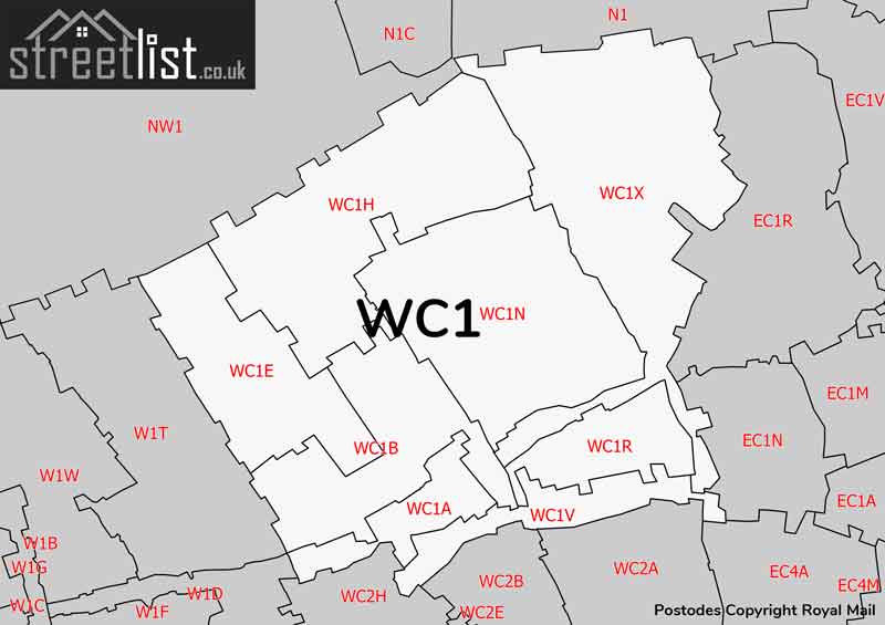
- WC1A: New Oxford Street
- WC1B: Bloomsbury
- WC1E: Birkbeck College
- WC1H: St Pancras
- WC1N: Russell Square
- WC1R: Gray's Inn
- WC1V: High Holborn
- WC1X: Kings Cross
- WC2A: Lincoln's Inn Fields
- WC2B: Drury Lane
- WC2E: Covent Garden
- WC2H: Leicester Square
- WC2N: Charing Cross
- WC2R: Somerset House
The History of London Postcodes
We often think postcodes were introduced between 1959 and 1974. However, they date back much further. By 1856, London was becoming a sprawling metropolis of over 3 million inhabitants. Simply addressing mail to 'London' was no longer practical.
Sir Rowland Hill: Father of the Penny Postage
Up steps Sir Rowland Hill, Postmaster born in 1795 and died in 1879. He would later be known affectionately as the "Father of the Penny Postage". He drew a circle with a 12-mile radius around London, with the central point being the Royal Mail Headquarters at St. Martins Le Grand. He then subdivided the city into 8 divisions based on the cardinal compass points.
Original Postal Subdivisions
| London Postal Area | Head Office Location |
|---|---|
| EC | St Martins Le Grand |
| WC | High Holborn |
| N | Lower Road, Islington |
| NE | Bethnal Green Road |
| E | Commercial Road East |
| SE | High Street Boro |
| S (now Sheffield) | Westminster Road |
| SW | Victoria Street, Pimlico |
| W | Vere Street, Oxford Street |
| NW (Now Newcastle) | Eversholt Street, Camden Town |
During the 1860’s, this was amended further with the S Area being merged into the SW and SE area and the NE division being absorbed into the E division.
Illustrations


These deleted areas still cause confusion to this day with S being reused for Sheffield and NE for Newcastle upon Tyne.

High Density Sub-divisions
As we moved through the 20th century, buildings in central London began to soar skywards. This intense urban development in the heart districts led to the need for further subdividing postal areas. As a result, letters were added to the end of the district codes, leading to designations like WC1A, EL1W, and others. If anyone has insights into how these specific numbers and letters were assigned, I'd be eager to learn.


W1

SW1