
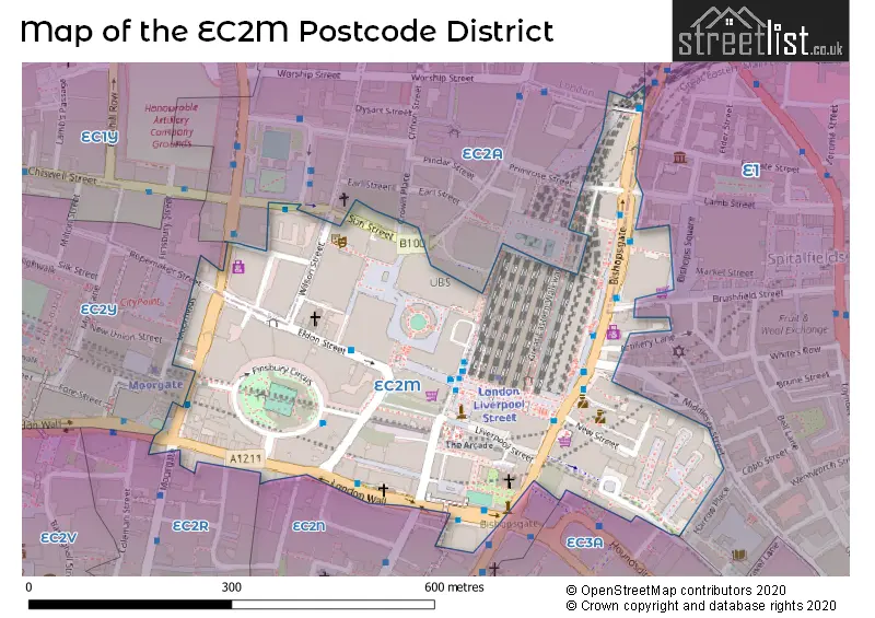
Map of the Postcode District
Explore the postcode district by using our interactive map.
Circles represent recorded crime; the larger the circle, the higher the crime rates.
Your support helps keep this site running!
If you enjoy using this website, consider buying me a coffee to help cover hosting costs.
The postcode district located in the EC London - EC postal area , EC2M has a population of 108 residents according to the 2021 England and Wales Census.
The area of the district is 0.11 square miles (0.29 square kilometers or 72.26 acres).
Where is the EC2M District?
To give you an idea where the district is located we have created the following table showing nearby towns.
Nearest Towns to EC2M
| Town | Distance (miles) | Direction |
|---|---|---|
| City of London | 0.48 | WSW |
| City of Westminster | 2.21 | WSW |
| Chigwell | 9.79 | NE |
| Loughton | 11.51 | NE |
| Waltham Cross | 11.78 | N |
| Waltham Abbey | 12.39 | NNE |
| Borehamwood | 12.64 | NW |
| Cheshunt | 12.87 | N |
| Potters Bar | 13.12 | NNW |
| Ewell | 13.70 | SSW |
| Swanley | 13.84 | SE |
| Warlingham | 14.44 | S |
| Banstead | 14.56 | SSW |
| Dartford | 14.86 | ESE |
| Bushey | 14.95 | NW |
| Epping | 14.98 | NNE |
| Epsom | 15.06 | SSW |
| Radlett | 15.30 | NW |
| Esher | 15.97 | SW |
| Sunbury-on-Thames | 16.03 | WSW |
The post town for this district is LONDON.
Postcode Information for District EC2M (Total Geographical Postcodes: 186)
| Location | Post Town | Sector | Number of Postcodes |
|---|---|---|---|
| City of London | LONDON | EC2M 4 | 38 |
| City of London | LONDON | EC2M 5 | 26 |
| City of London | LONDON | EC2M 3 | 26 |
| City of London | LONDON | EC2M 7 | 26 |
| City of London | LONDON | EC2M 2 | 16 |
| City of London | LONDON | EC2M 1 | 14 |
| Islington | LONDON | EC2M 2 | 11 |
| Islington | LONDON | EC2M 4 | 10 |
| City of London | LONDON | EC2M 6 | 7 |
| Tower Hamlets | LONDON | EC2M 4 | 3 |
| Hackney | LONDON | EC2M 2 | 3 |
| Islington | LONDON | EC2M 1 | 3 |
| Islington | LONDON | EC2M 3 | 2 |
| Islington | LONDON | EC2M 5 | 1 |
Retail and Shopping in EC2M
Street
Town
Locality
Number of Shops
Central Postcode
View on Google Maps
LIVERPOOL STREET
LONDON
49
EC2M 7PD
View on Google Maps
LIVERPOOL STREET STATION
LONDON
36
EC2M 7PY
View on Google Maps
LONDON WALL
LONDON
31
EC2M 5TE
View on Google Maps
BISHOPSGATE
LONDON
30
EC2M 4NQ
View on Google Maps
OLD BROAD STREET
LONDON
20
EC2M 1QS
View on Google Maps
MOORGATE
LONDON
14
EC2M 6AB
View on Google Maps
DEVONSHIRE SQUARE
LONDON
12
EC2M 4YR
View on Google Maps
ELDON STREET
LONDON
10
EC2M 7LS
View on Google Maps
WORMWOOD STREET
LONDON
9
EC2M 1RP
View on Google Maps
BROADGATE CIRCLE
LONDON
8
EC2M 2QS
View on Google Maps
BLOMFIELD STREET
LONDON
6
EC2M 7AW
View on Google Maps
FINSBURY AVENUE
LONDON
6
EC2M 2PA
View on Google Maps
| Street | Town | Locality | Number of Shops | Central Postcode | View on Google Maps |
|---|---|---|---|---|---|
| LIVERPOOL STREET | LONDON | 49 | EC2M 7PD | View on Google Maps | |
| LIVERPOOL STREET STATION | LONDON | 36 | EC2M 7PY | View on Google Maps | |
| LONDON WALL | LONDON | 31 | EC2M 5TE | View on Google Maps | |
| BISHOPSGATE | LONDON | 30 | EC2M 4NQ | View on Google Maps | |
| OLD BROAD STREET | LONDON | 20 | EC2M 1QS | View on Google Maps | |
| MOORGATE | LONDON | 14 | EC2M 6AB | View on Google Maps | |
| DEVONSHIRE SQUARE | LONDON | 12 | EC2M 4YR | View on Google Maps | |
| ELDON STREET | LONDON | 10 | EC2M 7LS | View on Google Maps | |
| WORMWOOD STREET | LONDON | 9 | EC2M 1RP | View on Google Maps | |
| BROADGATE CIRCLE | LONDON | 8 | EC2M 2QS | View on Google Maps | |
| BLOMFIELD STREET | LONDON | 6 | EC2M 7AW | View on Google Maps | |
| FINSBURY AVENUE | LONDON | 6 | EC2M 2PA | View on Google Maps |
The primary settlement in the EC2M postcode district is the City of London, which is located in the County of the City of London. Other significant settlements in this postcode district include Islington, Hackney, and Tower Hamlets, all of which are located in the Greater London area. The most significant post town in this district is London.
When it comes to local government, postal geography often disregards political borders. However, this district intersects the following councils: the district mostly encompasses the City and County of the City of London (142 postal codes), followed by the Islington London Boro area (25 postal codes), followed by the Hackney London Boro area (3 postal codes), and finally, the Tower Hamlets London Boro area (3 postal codes).
The largest settlements in the EC2M postal code are LONDON and ISLINGTON.
The EC2M Postcode shares a border with EC2N (LONDON), EC3A (LONDON), EC2R (LONDON), EC2Y (BARBICAN, LONDON) and EC2A (HACKNEY, ISLINGTON).


Stations in the Sector
London Liverpool Street
CRS Code: LST
Operator: NR
Line: Great Eastern Main Line|Lea Valley lines
Company:
Accessable Motorway Junctions
M1 J1
Average Driving Time from within the district: 21.97
Average Driving Distance: 9.31
Number of Postcodes that can access the Motorway Junction: 181
M4 J2
Average Driving Time from within the district: 24.01
Average Driving Distance: 10.18
Number of Postcodes that can access the Motorway Junction: 181
Weather Forecast for City Of London
| Time Period | Icon | Description | Temperature | Rain Probability | Wind |
|---|---|---|---|---|---|
| 12:00 to 15:00 | Partly cloudy (day) | 15.0°C (feels like 13.0°C) | 33.00% | WSW 9 mph | |
| 15:00 to 18:00 | Cloudy | 16.0°C (feels like 15.0°C) | 36.00% | WSW 7 mph | |
| 18:00 to 21:00 | Clear night | 14.0°C (feels like 13.0°C) | 9.00% | SW 4 mph | |
| 21:00 to 00:00 | Clear night | 12.0°C (feels like 12.0°C) | 1.00% | SW 4 mph |
| Time Period | Icon | Description | Temperature | Rain Probability | Wind |
|---|---|---|---|---|---|
| 00:00 to 03:00 | Partly cloudy (night) | 11.0°C (feels like 10.0°C) | 2.00% | SW 4 mph | |
| 03:00 to 06:00 | Partly cloudy (night) | 10.0°C (feels like 10.0°C) | 4.00% | SW 4 mph | |
| 06:00 to 09:00 | Fog | 10.0°C (feels like 10.0°C) | 14.00% | SSW 2 mph | |
| 09:00 to 12:00 | Fog | 12.0°C (feels like 11.0°C) | 13.00% | SSE 2 mph | |
| 12:00 to 15:00 | Cloudy | 16.0°C (feels like 15.0°C) | 6.00% | SSW 7 mph | |
| 15:00 to 18:00 | Partly cloudy (day) | 16.0°C (feels like 15.0°C) | 2.00% | SSW 7 mph | |
| 18:00 to 21:00 | Clear night | 13.0°C (feels like 12.0°C) | 0.00% | S 4 mph | |
| 21:00 to 00:00 | Clear night | 11.0°C (feels like 11.0°C) | 0.00% | SE 4 mph |
| Time Period | Icon | Description | Temperature | Rain Probability | Wind |
|---|---|---|---|---|---|
| 00:00 to 03:00 | Clear night | 11.0°C (feels like 10.0°C) | 0.00% | SE 7 mph | |
| 03:00 to 06:00 | Clear night | 11.0°C (feels like 9.0°C) | 1.00% | SE 7 mph | |
| 06:00 to 09:00 | Clear night | 10.0°C (feels like 9.0°C) | 1.00% | SE 7 mph | |
| 09:00 to 12:00 | Sunny day | 13.0°C (feels like 11.0°C) | 1.00% | SSE 9 mph | |
| 12:00 to 15:00 | Partly cloudy (day) | 16.0°C (feels like 14.0°C) | 1.00% | S 11 mph | |
| 15:00 to 18:00 | Sunny day | 17.0°C (feels like 15.0°C) | 2.00% | S 11 mph | |
| 18:00 to 21:00 | Clear night | 15.0°C (feels like 13.0°C) | 3.00% | SSE 9 mph | |
| 21:00 to 00:00 | Clear night | 15.0°C (feels like 13.0°C) | 7.00% | SSE 11 mph |
| Time Period | Icon | Description | Temperature | Rain Probability | Wind |
|---|---|---|---|---|---|
| 00:00 to 03:00 | Clear night | 15.0°C (feels like 13.0°C) | 18.00% | S 11 mph | |
| 03:00 to 06:00 | Cloudy | 14.0°C (feels like 12.0°C) | 18.00% | SSW 11 mph | |
| 06:00 to 09:00 | Cloudy | 12.0°C (feels like 11.0°C) | 13.00% | SSW 7 mph | |
| 09:00 to 12:00 | Partly cloudy (day) | 13.0°C (feels like 11.0°C) | 6.00% | SSW 9 mph | |
| 12:00 to 15:00 | Partly cloudy (day) | 14.0°C (feels like 12.0°C) | 10.00% | SW 11 mph | |
| 15:00 to 18:00 | Partly cloudy (day) | 14.0°C (feels like 12.0°C) | 10.00% | SW 11 mph | |
| 18:00 to 21:00 | Clear night | 12.0°C (feels like 10.0°C) | 7.00% | SW 11 mph | |
| 21:00 to 00:00 | Clear night | 10.0°C (feels like 8.0°C) | 1.00% | SW 9 mph |
| Time Period | Icon | Description | Temperature | Rain Probability | Wind |
|---|---|---|---|---|---|
| 00:00 to 03:00 | Clear night | 9.0°C (feels like 7.0°C) | 1.00% | SW 9 mph | |
| 03:00 to 06:00 | Clear night | 9.0°C (feels like 7.0°C) | 1.00% | SW 9 mph | |
| 06:00 to 09:00 | Clear night | 9.0°C (feels like 7.0°C) | 3.00% | SW 9 mph | |
| 09:00 to 12:00 | Sunny day | 11.0°C (feels like 8.0°C) | 7.00% | SW 11 mph | |
| 12:00 to 15:00 | Partly cloudy (day) | 13.0°C (feels like 11.0°C) | 9.00% | SW 13 mph | |
| 15:00 to 18:00 | Partly cloudy (day) | 14.0°C (feels like 11.0°C) | 11.00% | SW 11 mph | |
| 18:00 to 21:00 | Clear night | 12.0°C (feels like 10.0°C) | 9.00% | SW 11 mph | |
| 21:00 to 00:00 | Clear night | 11.0°C (feels like 10.0°C) | 6.00% | SW 11 mph |
| Postal Sector | Delivery Office |
|---|
| E | C | 2 | M | - | X | X | X |
| E | C | 2 | M | Space | Numeric | Letter | Letter |
Street List for the EC2M District
Current Monthly Rental Prices
| # Bedrooms | Min Price | Max Price | Avg Price |
|---|---|---|---|
| £1,712 | £1,712 | £1,712 | |
| 1 | £2,175 | £3,900 | £2,944 |
| 2 | £2,700 | £2,700 | £2,700 |
| 4 | £15,603 | £15,603 | £15,603 |
Current House Prices
| # Bedrooms | Min Price | Max Price | Avg Price |
|---|---|---|---|
| 1 | £1,160,000 | £1,160,000 | £1,160,000 |
| 2 | £1,990,000 | £1,990,000 | £1,990,000 |
| 4 | £3,000,000 | £3,000,000 | £3,000,000 |
Estate Agents
| Logo | Name | Brand Name | Address | Contact Number |
|---|---|---|---|---|
 | North Street | Livinc | 118 North Street, Leeds, LS2 7PN | 03333 239010 |
 | Friern Barnet | Woodhouse Estates | 235 Woodhouse Road, London, N12 9BD | 020 3866 6705 |
 | City | Dexters | 5A Sandys Row, London, E1 7HW | 020 7392 9111 |
 | Margaret Street | Savills New Homes | 33 Margaret Street London W1G 0JD | 020 3834 7939 |
 | Westminster | Century 21 London Central | 85 Rochester Row, London, SW1P 1LJ | 020 3869 5768 |
Yearly House Price Averages for the District
| Type of Property | 2018 Average | 2018 Sales | 2017 Average | 2017 Sales | 2016 Average | 2016 Sales | 2015 Average | 2015 Sales |
|---|---|---|---|---|---|---|---|---|
| Detached | £0 | 0 | £0 | 0 | £0 | 0 | £0 | 0 |
| Semi-Detached | £0 | 0 | £0 | 0 | £0 | 0 | £0 | 0 |
| Terraced | £0 | 0 | £0 | 0 | £0 | 0 | £0 | 0 |
| Flats | £0 | 0 | £552,500 | 2 | £631,750 | 1 | £520,750 | 4 |