The EC2V postcode district is a postal district located in the EC London - EC postcode area with a population of 23 residents according to the 2021 England and Wales Census.
The area of the EC2V postcode district is 0.07 square miles which is 0.18 square kilometres or 44.84 acres.
Currently, the EC2V district has about 105 postcode units spread across 4 geographic postcode sectors.
Given that each sector allows for 400 unique postcode combinations, the district has a capacity of 1,600 postcodes. With 105 postcodes already in use, this leaves 1495 units available.
The EC2V postal code covers the settlement of LONDON.
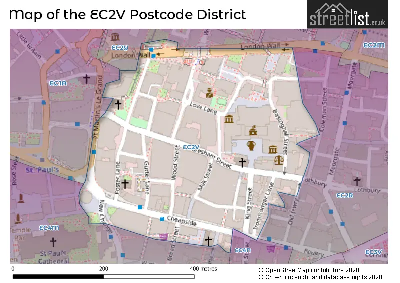
The EC2V Postcode shares a border with EC4N (LONDON), EC2R (LONDON) and EC2Y (BARBICAN, LONDON).
The primary settlement in the EC2V postcode district is City of London, located in the City and County of the City of London. Other significant settlements in this district include Islington. The most significant post town is London, which is situated within Greater London.
For the district EC2V, we have data on 4 postcode sectors. Here's a breakdown: The sector EC2V 5, covers City Of London in City and County of the City of London. The sector EC2V 6, covers City Of London in City and County of the City of London. The sector EC2V 7, covers City Of London in City and County of the City of London. The sector EC2V 8, covers City Of London in City and County of the City of London.

Map of the EC2V Postcode District
Explore the EC2V postcode district by using our free interactive map.
When it comes to local government, postal geography often disregards political borders. However, for a breakdown in the EC2V District: the district mostly encompasses the City and County of the City of London area with a total of 106 postcodes.
Recent House Sales in EC2V
| Date | Price | Address |
|---|---|---|
| 24/03/2023 | £5,000,000 | Gresham Street, London, EC2V 7AY |
| 01/01/2023 | £3,534,502 | Ropemaker Street, London, EC2V 0HR |
| 19/04/2022 | £117,725 | King Street, London, EC2V 8EH |
| 19/04/2022 | £143,450 | King Street, London, EC2V 8EH |
| 12/04/2022 | £10,655,000 | Ironmonger Lane, London, EC2V 8EY |
| 12/04/2022 | £10,655,000 | Ironmonger Lane, London, EC2V 8EY |
| 18/03/2022 | £45,196,950 | King Street, London, EC2V 8EE |
| 18/03/2022 | £45,196,950 | King Street, London, EC2V 8LN |
| 09/07/2021 | £2,500,000 | King Street, London, EC2V 8EA |
| 21/09/2020 | £2,500 | Gresham Street, London, EC2V 7BX |
Weather Forecast for EC2V
Press Button to Show Forecast for City Of London Youth Hostel
| Time Period | Icon | Description | Temperature | Rain Probability | Wind |
|---|---|---|---|---|---|
| 09:00 to 12:00 | Overcast | 8.0°C (feels like 6.0°C) | 17.00% | NE 9 mph | |
| 12:00 to 15:00 | Overcast | 11.0°C (feels like 10.0°C) | 15.00% | NE 7 mph | |
| 15:00 to 18:00 | Cloudy | 13.0°C (feels like 12.0°C) | 14.00% | NE 7 mph | |
| 18:00 to 21:00 | Heavy rain | 12.0°C (feels like 10.0°C) | 82.00% | ENE 9 mph | |
| 21:00 to 00:00 | Heavy rain | 10.0°C (feels like 8.0°C) | 88.00% | NE 9 mph |
Press Button to Show Forecast for City Of London Youth Hostel
| Time Period | Icon | Description | Temperature | Rain Probability | Wind |
|---|---|---|---|---|---|
| 00:00 to 03:00 | Heavy rain | 9.0°C (feels like 7.0°C) | 89.00% | NNE 9 mph | |
| 03:00 to 06:00 | Heavy rain | 9.0°C (feels like 7.0°C) | 89.00% | NNE 9 mph | |
| 06:00 to 09:00 | Heavy rain | 9.0°C (feels like 7.0°C) | 85.00% | N 7 mph | |
| 09:00 to 12:00 | Light rain | 10.0°C (feels like 7.0°C) | 58.00% | WNW 9 mph | |
| 12:00 to 15:00 | Light rain | 10.0°C (feels like 8.0°C) | 55.00% | WNW 11 mph | |
| 15:00 to 18:00 | Cloudy | 11.0°C (feels like 9.0°C) | 18.00% | W 11 mph | |
| 18:00 to 21:00 | Cloudy | 11.0°C (feels like 10.0°C) | 10.00% | WSW 9 mph | |
| 21:00 to 00:00 | Partly cloudy (night) | 10.0°C (feels like 8.0°C) | 6.00% | SW 7 mph |
Press Button to Show Forecast for City Of London Youth Hostel
| Time Period | Icon | Description | Temperature | Rain Probability | Wind |
|---|---|---|---|---|---|
| 00:00 to 03:00 | Partly cloudy (night) | 8.0°C (feels like 7.0°C) | 2.00% | SW 4 mph | |
| 03:00 to 06:00 | Clear night | 7.0°C (feels like 6.0°C) | 1.00% | SSW 4 mph | |
| 06:00 to 09:00 | Sunny day | 8.0°C (feels like 6.0°C) | 1.00% | S 4 mph | |
| 09:00 to 12:00 | Sunny day | 12.0°C (feels like 10.0°C) | 1.00% | S 9 mph | |
| 12:00 to 15:00 | Cloudy | 15.0°C (feels like 12.0°C) | 8.00% | S 11 mph | |
| 15:00 to 18:00 | Partly cloudy (day) | 15.0°C (feels like 13.0°C) | 4.00% | S 11 mph | |
| 18:00 to 21:00 | Sunny day | 14.0°C (feels like 12.0°C) | 4.00% | S 9 mph | |
| 21:00 to 00:00 | Clear night | 12.0°C (feels like 10.0°C) | 1.00% | SSE 7 mph |
Press Button to Show Forecast for City Of London Youth Hostel
| Time Period | Icon | Description | Temperature | Rain Probability | Wind |
|---|---|---|---|---|---|
| 00:00 to 03:00 | Clear night | 10.0°C (feels like 9.0°C) | 1.00% | SE 7 mph | |
| 03:00 to 06:00 | Clear night | 9.0°C (feels like 8.0°C) | 3.00% | ESE 7 mph | |
| 06:00 to 09:00 | Partly cloudy (day) | 10.0°C (feels like 8.0°C) | 5.00% | ESE 7 mph | |
| 09:00 to 12:00 | Cloudy | 13.0°C (feels like 12.0°C) | 7.00% | ESE 7 mph | |
| 12:00 to 15:00 | Cloudy | 16.0°C (feels like 14.0°C) | 12.00% | SE 9 mph | |
| 15:00 to 18:00 | Cloudy | 17.0°C (feels like 15.0°C) | 13.00% | SE 9 mph | |
| 18:00 to 21:00 | Cloudy | 16.0°C (feels like 15.0°C) | 11.00% | SE 9 mph | |
| 21:00 to 00:00 | Light rain shower (night) | 14.0°C (feels like 13.0°C) | 35.00% | ESE 7 mph |
Where is the EC2V Postcode District?
The postcode district EC2V is located in London. It is specifically situated in the LONDON district. Nearby towns include Barbican, which is 0.276 miles away to the north, and Inner Temple, which is 0.705 miles away to the west. The postcode district EC2V is approximately 1.572 miles away from the center of London.
The district is within the post town of LONDON.
The sector has postcodes within the nation of England.
The EC2V Postcode District is covers the following regions.
- Camden and City of London - Inner London - West - London
- Haringey and Islington - Inner London - East - London
| Postcode Sector | Delivery Office |
|---|
| E | C | 2 | V | - | X | X | X |
| E | C | 2 | V | Space | Numeric | Letter | Letter |
Tourist Attractions within the Postcode Area
We found 4 visitor attractions within the EC2V postcode area
| St Vedast-alias-Foster Church |
|---|
| Places of Worship |
| Place of Worship (still in use) |
| View St Vedast-alias-Foster Church on Google Maps |
| The Guildhall |
| Historic Properties |
| Other Historic Property |
| View The Guildhall on Google Maps |
| The Guildhall |
| Historic Properties |
| Other Historic Property |
| View The Guildhall on Google Maps |
| Guildhall Art Gallery |
| Museums & Art Galleries |
| Museum and / or Art Gallery |
| View Guildhall Art Gallery on Google Maps |
Current Monthly Rental Prices
| # Bedrooms | Min Price | Max Price | Avg Price |
|---|
Current House Prices
| # Bedrooms | Min Price | Max Price | Avg Price |
|---|
Estate Agents who Operate in the EC2V District
| Logo | Name | Brand Name | Address | Contact Number | Total Properties |
|---|
| Type of Property | 2018 Average | 2018 Sales | 2017 Average | 2017 Sales | 2016 Average | 2016 Sales | 2015 Average | 2015 Sales |
|---|---|---|---|---|---|---|---|---|
| Detached | £0 | 0 | £0 | 0 | £0 | 0 | £0 | 0 |
| Semi-Detached | £0 | 0 | £0 | 0 | £0 | 0 | £0 | 0 |
| Terraced | £0 | 0 | £0 | 0 | £0 | 0 | £0 | 0 |
| Flats | £1,900,000 | 1 | £0 | 0 | £300,000 | 1 | £200,000 | 1 |