The EC4N postcode district is a postal district located in the EC London - EC postcode area with a population of 42 residents according to the 2021 England and Wales Census.
The area of the EC4N postcode district is 0.04 square miles which is 0.10 square kilometres or 23.53 acres.
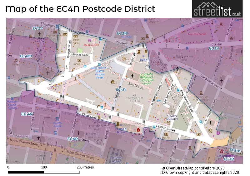
Currently, the EC4N district has about 74 postcode units spread across 6 geographic postcode sectors.
Given that each sector allows for 400 unique postcode combinations, the district has a capacity of 2,400 postcodes. With 74 postcodes already in use, this leaves 2326 units available.
The EC4N postal code covers the settlement of LONDON.
The EC4N Postcode shares a border with EC4M (LONDON), EC2R (LONDON), EC2V (LONDON) and EC4R (LONDON).
The primary settlement in the EC4N postcode district is City of London. It is located in the City and County of the City of London. Islington is also a significant settlement within the district, located in Greater London. The post town for the district is London.
For the district EC4N, we have data on 6 postcode sectors. Here's a breakdown: The sector EC4N 1, covers City Of London in City and County of the City of London. The sector EC4N 4, covers City Of London in City and County of the City of London. The sector EC4N 5, covers City Of London in City and County of the City of London. The sector EC4N 6, covers City Of London in City and County of the City of London. The sector EC4N 7, covers City Of London in City and County of the City of London. The sector EC4N 7, covers Islington in Greater London. The sector EC4N 8, covers City Of London in City and County of the City of London.

Map of the EC4N Postcode District
Explore the EC4N postcode district by using our free interactive map.
When it comes to local government, postal geography often disregards political borders. However, for a breakdown in the EC4N District: the district mostly encompasses the City and County of the City of London (68 postcodes), and finally, the Islington London Boro area (4 postcodes).
Recent House Sales in EC4N
| Date | Price | Address |
|---|---|---|
| 31/05/2022 | £27,768,685 | Cannon Street, London, EC4N 5AD |
| 28/04/2022 | £30,000,000 | Cannon Street, London, EC4N 6JJ |
| 26/11/2021 | £492,000 | King William Street, London, EC4N 7HR |
| 29/10/2021 | £52,500,000 | Cannon Street, London, EC4N 6HL |
| 22/07/2021 | £130,500,000 | King William Street, London, EC4N 7BL |
| 22/07/2021 | £130,500,000 | King William Street, London, EC4N 7BL |
| 22/07/2021 | £130,500,000 | King William Street, London, EC4N 7BL |
| 08/09/2020 | £17,000,000 | Cannon Street, London, EC4N 6AE |
Weather Forecast for EC4N
Press Button to Show Forecast for City Of London
| Time Period | Icon | Description | Temperature | Rain Probability | Wind |
|---|---|---|---|---|---|
| 00:00 to 03:00 | Overcast | 8.0°C (feels like 6.0°C) | 25.00% | ENE 9 mph | |
| 03:00 to 06:00 | Heavy rain | 7.0°C (feels like 5.0°C) | 80.00% | ENE 9 mph | |
| 06:00 to 09:00 | Light rain | 7.0°C (feels like 4.0°C) | 56.00% | NE 9 mph | |
| 09:00 to 12:00 | Overcast | 8.0°C (feels like 5.0°C) | 17.00% | NE 9 mph | |
| 12:00 to 15:00 | Overcast | 11.0°C (feels like 10.0°C) | 15.00% | NE 7 mph | |
| 15:00 to 18:00 | Cloudy | 13.0°C (feels like 11.0°C) | 14.00% | NE 7 mph | |
| 18:00 to 21:00 | Heavy rain | 12.0°C (feels like 10.0°C) | 82.00% | ENE 9 mph | |
| 21:00 to 00:00 | Heavy rain | 10.0°C (feels like 8.0°C) | 88.00% | NE 9 mph |
Press Button to Show Forecast for City Of London
| Time Period | Icon | Description | Temperature | Rain Probability | Wind |
|---|---|---|---|---|---|
| 00:00 to 03:00 | Heavy rain | 9.0°C (feels like 7.0°C) | 89.00% | NNE 9 mph | |
| 03:00 to 06:00 | Heavy rain | 9.0°C (feels like 7.0°C) | 89.00% | NNE 9 mph | |
| 06:00 to 09:00 | Heavy rain | 9.0°C (feels like 7.0°C) | 85.00% | N 7 mph | |
| 09:00 to 12:00 | Light rain | 9.0°C (feels like 7.0°C) | 58.00% | WNW 9 mph | |
| 12:00 to 15:00 | Light rain | 10.0°C (feels like 7.0°C) | 55.00% | WNW 11 mph | |
| 15:00 to 18:00 | Cloudy | 11.0°C (feels like 9.0°C) | 18.00% | W 11 mph | |
| 18:00 to 21:00 | Cloudy | 11.0°C (feels like 9.0°C) | 10.00% | WSW 9 mph | |
| 21:00 to 00:00 | Partly cloudy (night) | 10.0°C (feels like 8.0°C) | 6.00% | SW 7 mph |
Press Button to Show Forecast for City Of London
| Time Period | Icon | Description | Temperature | Rain Probability | Wind |
|---|---|---|---|---|---|
| 00:00 to 03:00 | Partly cloudy (night) | 8.0°C (feels like 7.0°C) | 2.00% | SW 4 mph | |
| 03:00 to 06:00 | Clear night | 7.0°C (feels like 6.0°C) | 1.00% | SSW 4 mph | |
| 06:00 to 09:00 | Sunny day | 8.0°C (feels like 6.0°C) | 1.00% | S 4 mph | |
| 09:00 to 12:00 | Sunny day | 12.0°C (feels like 10.0°C) | 1.00% | S 9 mph | |
| 12:00 to 15:00 | Cloudy | 15.0°C (feels like 12.0°C) | 8.00% | S 11 mph | |
| 15:00 to 18:00 | Partly cloudy (day) | 15.0°C (feels like 13.0°C) | 4.00% | S 11 mph | |
| 18:00 to 21:00 | Sunny day | 14.0°C (feels like 12.0°C) | 4.00% | S 9 mph | |
| 21:00 to 00:00 | Clear night | 11.0°C (feels like 10.0°C) | 1.00% | SSE 7 mph |
Press Button to Show Forecast for City Of London
| Time Period | Icon | Description | Temperature | Rain Probability | Wind |
|---|---|---|---|---|---|
| 00:00 to 03:00 | Clear night | 10.0°C (feels like 9.0°C) | 1.00% | SE 7 mph | |
| 03:00 to 06:00 | Clear night | 9.0°C (feels like 8.0°C) | 3.00% | ESE 7 mph | |
| 06:00 to 09:00 | Partly cloudy (day) | 10.0°C (feels like 8.0°C) | 5.00% | ESE 7 mph | |
| 09:00 to 12:00 | Cloudy | 13.0°C (feels like 12.0°C) | 7.00% | ESE 7 mph | |
| 12:00 to 15:00 | Cloudy | 16.0°C (feels like 14.0°C) | 12.00% | SE 9 mph | |
| 15:00 to 18:00 | Cloudy | 17.0°C (feels like 15.0°C) | 13.00% | SE 9 mph | |
| 18:00 to 21:00 | Cloudy | 16.0°C (feels like 15.0°C) | 11.00% | SE 9 mph | |
| 21:00 to 00:00 | Light rain shower (night) | 14.0°C (feels like 13.0°C) | 35.00% | ESE 7 mph |
Where is the EC4N Postcode District?
The postcode district EC4N is located in the town of London. It is in close proximity to the nearby towns of Barbican, Inner Temple, Holborn and Covent Garden, and St George's. The distance from EC4N to the center of London is approximately 1.6580680975758755 miles.
The district is within the post town of LONDON.
The sector has postcodes within the nation of England.
The EC4N Postcode District is covers the following regions.
- Camden and City of London - Inner London - West - London
- Haringey and Islington - Inner London - East - London
| Postcode Sector | Delivery Office |
|---|
| E | C | 4 | N | - | X | X | X |
| E | C | 4 | N | Space | Numeric | Letter | Letter |
Tourist Attractions within the Postcode Area
We found 1 visitor attractions within the EC4N postcode area
| Mansion House |
|---|
| Historic Properties |
| Historic House / House and Garden / Palace |
| View Mansion House on Google Maps |
Current Monthly Rental Prices
| # Bedrooms | Min Price | Max Price | Avg Price |
|---|
Current House Prices
| # Bedrooms | Min Price | Max Price | Avg Price |
|---|
Estate Agents who Operate in the EC4N District
| Logo | Name | Brand Name | Address | Contact Number | Total Properties |
|---|
| Type of Property | 2018 Average | 2018 Sales | 2017 Average | 2017 Sales | 2016 Average | 2016 Sales | 2015 Average | 2015 Sales |
|---|---|---|---|---|---|---|---|---|
| Detached | £0 | 0 | £0 | 0 | £0 | 0 | £0 | 0 |
| Semi-Detached | £0 | 0 | £0 | 0 | £0 | 0 | £0 | 0 |
| Terraced | £0 | 0 | £6,084,000 | 2 | £0 | 0 | £0 | 0 |
| Flats | £0 | 0 | £0 | 0 | £0 | 0 | £0 | 0 |