The EC4Y postcode district is a postal district located in the EC London - EC postcode area with a population of 226 residents according to the 2021 England and Wales Census.
The area of the EC4Y postcode district is 0.07 square miles which is 0.18 square kilometres or 44.33 acres.
Currently, the EC4Y district has about 134 postcode units spread across 5 geographic postcode sectors.
Given that each sector allows for 400 unique postcode combinations, the district has a capacity of 2,000 postcodes. With 134 postcodes already in use, this leaves 1866 units available.
The largest settlement in the EC4Y postal code is LONDON followed by MIDDLE TEMPLE, and INNER TEMPLE.
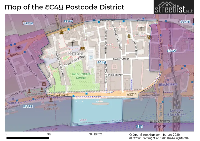
The postcode area has a boundary with Tidal Thames.
The EC4Y Postcode shares a border with EC4M (LONDON), EC4A (LONDON) and EC4V (LONDON).
The primary settlement in the EC4Y postcode district is City of London, located in the County of the City of London. Other significant settlements include Islington and Westminster, both of which are located in Greater London. The post town for this postcode district is London.
For the district EC4Y, we have data on 5 postcode sectors. Here's a breakdown: The sector EC4Y 0, covers City Of London in City and County of the City of London. The sector EC4Y 1, covers City Of London in City and County of the City of London. The sector EC4Y 7, covers City Of London in City and County of the City of London. The sector EC4Y 8, covers City Of London in City and County of the City of London. The sector EC4Y 9, covers City Of London in City and County of the City of London. The sector EC4Y 9, covers Westminster in Greater London.

Map of the EC4Y Postcode District
Explore the EC4Y postcode district by using our free interactive map.
When it comes to local government, postal geography often disregards political borders. However, for a breakdown in the EC4Y District: the district mostly encompasses the City and County of the City of London (128 postcodes), and finally, the City of Westminster London Boro area (3 postcodes).
Recent House Sales in EC4Y
| Date | Price | Address |
|---|---|---|
| 27/09/2023 | £925,000 | Tudor Street, London, EC4Y 0DD |
| 25/07/2023 | £940,000 | Tudor Street, London, EC4Y 0DD |
| 24/03/2023 | £2,600,000 | Fleet Street, London, EC4Y 1AA |
| 24/03/2023 | £32,350,000 | Bouverie Street, London, EC4Y 8AX |
| 16/09/2022 | £885,000 | Tudor Street, London, EC4Y 0DD |
| 13/05/2022 | £642,000 | Tudor Street, London, EC4Y 0AY |
| 17/12/2021 | £33,000,000 | Temple Avenue, London, EC4Y 0HP |
| 17/12/2021 | £950,000 | Temple Avenue, London, EC4Y 0DF |
| 29/11/2021 | £823,912 | Lombard Lane, London, EC4Y 8AD |
| 29/09/2021 | £880,000 | Temple Avenue, London, EC4Y 0DF |
Weather Forecast for EC4Y
Press Button to Show Forecast for City Of London Youth Hostel
| Time Period | Icon | Description | Temperature | Rain Probability | Wind |
|---|---|---|---|---|---|
| 03:00 to 06:00 | Cloudy | 6.0°C (feels like 4.0°C) | 5.00% | NE 7 mph | |
| 06:00 to 09:00 | Cloudy | 5.0°C (feels like 3.0°C) | 4.00% | NE 7 mph | |
| 09:00 to 12:00 | Cloudy | 8.0°C (feels like 6.0°C) | 4.00% | ENE 7 mph | |
| 12:00 to 15:00 | Cloudy | 11.0°C (feels like 9.0°C) | 11.00% | ENE 7 mph | |
| 15:00 to 18:00 | Cloudy | 11.0°C (feels like 10.0°C) | 13.00% | ENE 7 mph | |
| 18:00 to 21:00 | Cloudy | 10.0°C (feels like 9.0°C) | 13.00% | E 7 mph | |
| 21:00 to 00:00 | Cloudy | 8.0°C (feels like 6.0°C) | 11.00% | E 7 mph |
Press Button to Show Forecast for City Of London Youth Hostel
| Time Period | Icon | Description | Temperature | Rain Probability | Wind |
|---|---|---|---|---|---|
| 00:00 to 03:00 | Cloudy | 6.0°C (feels like 4.0°C) | 17.00% | ENE 7 mph | |
| 03:00 to 06:00 | Cloudy | 6.0°C (feels like 4.0°C) | 18.00% | NE 7 mph | |
| 06:00 to 09:00 | Cloudy | 6.0°C (feels like 4.0°C) | 17.00% | NE 7 mph | |
| 09:00 to 12:00 | Overcast | 10.0°C (feels like 8.0°C) | 18.00% | ENE 9 mph | |
| 12:00 to 15:00 | Cloudy | 12.0°C (feels like 10.0°C) | 14.00% | E 9 mph | |
| 15:00 to 18:00 | Light rain | 13.0°C (feels like 11.0°C) | 51.00% | E 11 mph | |
| 18:00 to 21:00 | Light rain | 11.0°C (feels like 9.0°C) | 54.00% | ENE 9 mph | |
| 21:00 to 00:00 | Light rain | 10.0°C (feels like 8.0°C) | 54.00% | ENE 11 mph |
Press Button to Show Forecast for City Of London Youth Hostel
| Time Period | Icon | Description | Temperature | Rain Probability | Wind |
|---|---|---|---|---|---|
| 00:00 to 03:00 | Heavy rain | 10.0°C (feels like 8.0°C) | 75.00% | NE 9 mph | |
| 03:00 to 06:00 | Light rain | 10.0°C (feels like 8.0°C) | 56.00% | ESE 9 mph | |
| 06:00 to 09:00 | Light rain | 10.0°C (feels like 8.0°C) | 50.00% | SE 7 mph | |
| 09:00 to 12:00 | Light rain shower (day) | 11.0°C (feels like 9.0°C) | 45.00% | SE 9 mph | |
| 12:00 to 15:00 | Heavy rain shower (day) | 13.0°C (feels like 11.0°C) | 61.00% | S 9 mph | |
| 15:00 to 18:00 | Light rain shower (day) | 14.0°C (feels like 12.0°C) | 39.00% | SSW 11 mph | |
| 18:00 to 21:00 | Partly cloudy (day) | 13.0°C (feels like 11.0°C) | 13.00% | SW 11 mph | |
| 21:00 to 00:00 | Cloudy | 11.0°C (feels like 9.0°C) | 9.00% | SSW 7 mph |
Where is the EC4Y Postcode District?
The postcode district of EC4Y is located in the town of London. It is in close proximity to the following nearby towns: Inner Temple, Middle Temple, Holborn and Covent Garden, Barbican, and St George's. The district is approximately 0.91 miles away from the center of London.
The district is within the post town of LONDON.
The sector has postcodes within the nation of England.
The EC4Y Postcode District is covers the following regions.
- Camden and City of London - Inner London - West - London
- Haringey and Islington - Inner London - East - London
- Westminster - Inner London - West - London
| Postcode Sector | Delivery Office |
|---|
| E | C | 4 | Y | - | X | X | X |
| E | C | 4 | Y | Space | Numeric | Letter | Letter |
Tourist Attractions within the Postcode Area
We found 1 visitor attractions within the EC4Y postcode area
| The Temple |
|---|
| Country Parks |
| Country Park |
| View The Temple on Google Maps |
Current Monthly Rental Prices
| # Bedrooms | Min Price | Max Price | Avg Price |
|---|---|---|---|
| 1 | £1,993 | £1,993 | £1,993 |
| 2 | £3,033 | £4,250 | £3,538 |
Current House Prices
| # Bedrooms | Min Price | Max Price | Avg Price |
|---|---|---|---|
| 2 | £1,150,000 | £1,400,000 | £1,275,000 |
Estate Agents who Operate in the EC4Y District
| Logo | Name | Brand Name | Address | Contact Number | Total Properties |
|---|---|---|---|---|---|
 | Clerkenwell | Savills Lettings | 122-124 St. John Street, London, EC1V 4JS | 020 3834 8405 | 2 |
 | London | BLUEGROUND FURNISHED APARTMENTS UK LTD | 66-67 Newman Street, Office 503 London, W1T 3EQ | 020 3319 6480 | 1 |
 | London | PRIME PORTFOLIO | 22 Grosvenor Gardens, London, SW1W 0DH | 020 3835 4067 | 1 |
 | Covent Garden Lettings | Chestertons Estate Agents | 196 Shaftesbury Avenue, Covent Garden, London, WC2H 8JF | 020 3872 5331 | 1 |
 | City, Barbican & Clerkenwell | Frank Harris & Co. | 87 Long Lane, London, EC1A 9ET | 020 7601 1919 | 1 |
| Type of Property | 2018 Average | 2018 Sales | 2017 Average | 2017 Sales | 2016 Average | 2016 Sales | 2015 Average | 2015 Sales |
|---|---|---|---|---|---|---|---|---|
| Detached | £0 | 0 | £0 | 0 | £0 | 0 | £0 | 0 |
| Semi-Detached | £0 | 0 | £0 | 0 | £0 | 0 | £0 | 0 |
| Terraced | £0 | 0 | £0 | 0 | £2,125,000 | 1 | £0 | 0 |
| Flats | £1,081,000 | 3 | £931,250 | 4 | £1,021,603 | 2 | £715,000 | 5 |