The EC4A postcode district is a postal district located in the EC London - EC postcode area with a population of 383 residents according to the 2021 England and Wales Census.
The area of the EC4A postcode district is 0.07 square miles which is 0.17 square kilometres or 42.48 acres.
Currently, the EC4A district has about 115 postcode units spread across 4 geographic postcode sectors.
Given that each sector allows for 400 unique postcode combinations, the district has a capacity of 1,600 postcodes. With 115 postcodes already in use, this leaves 1485 units available.
The EC4A postal code covers the settlement of LONDON.
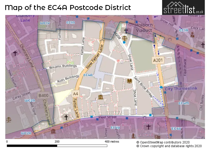
The EC4A Postcode shares a border with WC2A (LONDON), EC4Y (LONDON, MIDDLE TEMPLE, INNER TEMPLE), EC1N (LONDON), EC1A (LONDON, ISLINGTON) and WC1V (LONDON).
The primary settlement in the EC4A postcode district is the City of London. It is located in the County of the City of London in Greater London. Other significant settlements in the district include Islington and Westminster, both located in Greater London. The post town associated with this district is London.
For the district EC4A, we have data on 4 postcode sectors. Here's a breakdown: The sector EC4A 1, covers City Of London in City and County of the City of London. The sector EC4A 2, covers City Of London in City and County of the City of London. The sector EC4A 3, covers City Of London in City and County of the City of London. The sector EC4A 4, covers City Of London in City and County of the City of London.

Map of the EC4A Postcode District
Explore the EC4A postcode district by using our free interactive map.
When it comes to local government, postal geography often disregards political borders. However, for a breakdown in the EC4A District: the district mostly encompasses the City and County of the City of London (107 postcodes), and finally, the Islington London Boro area (3 postcodes).
Recent House Sales in EC4A
| Date | Price | Address |
|---|---|---|
| 25/07/2023 | £570,000 | Fetter Lane, London, EC4A 1BY |
| 13/07/2023 | £930,000 | Fetter Lane, London, EC4A 1BY |
| 23/06/2023 | £2,500,000 | Furnival Street, London, EC4A 1JQ |
| 09/06/2023 | £1,140,000 | St Andrew Street, London, EC4A 3AG |
| 21/04/2023 | £1,347,500 | Greystoke Place, London, EC4A 1GP |
| 05/04/2023 | £452,000 | Fetter Lane, London, EC4A 1BX |
| 04/04/2023 | £5,750,000 | Furnival Street, London, EC4A 1JQ |
| 31/03/2023 | £11,250,000 | Cursitor Street, London, EC4A 1LL |
| 20/01/2023 | £710,000 | Fetter Lane, London, EC4A 1BF |
| 19/12/2022 | £2,000,000 | Wine Office Court, London, EC4A 3BY |
Where is the EC4A Postcode District?
The EC4A postcode district is located in London. It is near several towns, including Inner Temple to the South (0.21 miles away), Middle Temple to the South West (0.27 miles away), Holborn and Covent Garden to the North West (0.31 miles away), Barbican to the North East (0.66 miles away), and Covent Garden to the West (0.72 miles away). The district is approximately 1.03 miles away from the center of London.
The district is within the post town of LONDON.
The sector has postcodes within the nation of England.
The EC4A Postcode District is covers the following regions.
- Camden and City of London - Inner London - West - London
- Haringey and Islington - Inner London - East - London
- Westminster - Inner London - West - London
Weather Forecast for EC4A
Press Button to Show Forecast for City Of London Youth Hostel
| Time Period | Icon | Description | Temperature | Rain Probability | Wind |
|---|---|---|---|---|---|
| 03:00 to 06:00 | Cloudy | 13.0°C (feels like 13.0°C) | 5.00% | ESE 4 mph | |
| 06:00 to 09:00 | Cloudy | 13.0°C (feels like 13.0°C) | 7.00% | E 2 mph | |
| 09:00 to 12:00 | Cloudy | 14.0°C (feels like 14.0°C) | 13.00% | ENE 4 mph | |
| 12:00 to 15:00 | Overcast | 17.0°C (feels like 16.0°C) | 18.00% | NE 4 mph | |
| 15:00 to 18:00 | Cloudy | 18.0°C (feels like 17.0°C) | 10.00% | NE 4 mph | |
| 18:00 to 21:00 | Cloudy | 18.0°C (feels like 17.0°C) | 5.00% | NNE 7 mph | |
| 21:00 to 00:00 | Cloudy | 16.0°C (feels like 15.0°C) | 6.00% | N 9 mph |
Press Button to Show Forecast for City Of London Youth Hostel
| Time Period | Icon | Description | Temperature | Rain Probability | Wind |
|---|---|---|---|---|---|
| 00:00 to 03:00 | Light rain | 12.0°C (feels like 11.0°C) | 47.00% | NNE 9 mph | |
| 03:00 to 06:00 | Overcast | 11.0°C (feels like 10.0°C) | 49.00% | NNE 7 mph | |
| 06:00 to 09:00 | Overcast | 12.0°C (feels like 11.0°C) | 12.00% | N 7 mph | |
| 09:00 to 12:00 | Overcast | 14.0°C (feels like 14.0°C) | 16.00% | N 4 mph | |
| 12:00 to 15:00 | Cloudy | 17.0°C (feels like 17.0°C) | 8.00% | NW 7 mph | |
| 15:00 to 18:00 | Cloudy | 19.0°C (feels like 18.0°C) | 13.00% | NW 7 mph | |
| 18:00 to 21:00 | Light rain shower (day) | 18.0°C (feels like 16.0°C) | 38.00% | NW 9 mph | |
| 21:00 to 00:00 | Light rain shower (night) | 15.0°C (feels like 14.0°C) | 39.00% | WNW 9 mph |
Press Button to Show Forecast for City Of London Youth Hostel
| Time Period | Icon | Description | Temperature | Rain Probability | Wind |
|---|---|---|---|---|---|
| 00:00 to 03:00 | Cloudy | 13.0°C (feels like 12.0°C) | 13.00% | NW 7 mph | |
| 03:00 to 06:00 | Light rain | 12.0°C (feels like 10.0°C) | 46.00% | NW 7 mph | |
| 06:00 to 09:00 | Overcast | 11.0°C (feels like 10.0°C) | 25.00% | W 9 mph | |
| 09:00 to 12:00 | Light rain | 12.0°C (feels like 11.0°C) | 49.00% | W 9 mph | |
| 12:00 to 15:00 | Overcast | 14.0°C (feels like 12.0°C) | 18.00% | W 11 mph | |
| 15:00 to 18:00 | Overcast | 16.0°C (feels like 14.0°C) | 19.00% | W 11 mph | |
| 18:00 to 21:00 | Overcast | 16.0°C (feels like 14.0°C) | 14.00% | W 9 mph | |
| 21:00 to 00:00 | Cloudy | 14.0°C (feels like 12.0°C) | 10.00% | W 9 mph |
Press Button to Show Forecast for City Of London Youth Hostel
| Time Period | Icon | Description | Temperature | Rain Probability | Wind |
|---|---|---|---|---|---|
| 00:00 to 03:00 | Cloudy | 12.0°C (feels like 11.0°C) | 9.00% | WSW 7 mph | |
| 03:00 to 06:00 | Clear night | 11.0°C (feels like 9.0°C) | 4.00% | WSW 7 mph | |
| 06:00 to 09:00 | Partly cloudy (day) | 10.0°C (feels like 9.0°C) | 4.00% | WSW 7 mph | |
| 09:00 to 12:00 | Partly cloudy (day) | 13.0°C (feels like 12.0°C) | 4.00% | SW 7 mph | |
| 12:00 to 15:00 | Cloudy | 16.0°C (feels like 15.0°C) | 6.00% | SW 9 mph | |
| 15:00 to 18:00 | Cloudy | 17.0°C (feels like 16.0°C) | 8.00% | SW 9 mph | |
| 18:00 to 21:00 | Cloudy | 17.0°C (feels like 15.0°C) | 11.00% | SW 9 mph | |
| 21:00 to 00:00 | Cloudy | 15.0°C (feels like 14.0°C) | 8.00% | SSW 7 mph |
| Postcode Sector | Delivery Office |
|---|
| E | C | 4 | A | - | X | X | X |
| E | C | 4 | A | Space | Numeric | Letter | Letter |
Tourist Attractions within the Postcode Area
We found 1 visitor attractions within the EC4A postcode area
| Doctor Johnson's House |
|---|
| Historic Properties |
| Historic House / House and Garden / Palace |
| View Doctor Johnson's House on Google Maps |
Current Monthly Rental Prices
| # Bedrooms | Min Price | Max Price | Avg Price |
|---|---|---|---|
| £1,560 | £2,817 | £2,011 | |
| 1 | £2,167 | £3,250 | £2,734 |
| 2 | £2,903 | £7,800 | £5,352 |
Current House Prices
| # Bedrooms | Min Price | Max Price | Avg Price |
|---|---|---|---|
| £355,000 | £450,000 | £412,500 | |
| 1 | £595,000 | £1,100,000 | £771,667 |
| 2 | £1,150,000 | £1,600,000 | £1,400,000 |
Estate Agents who Operate in the EC4A District
| Logo | Name | Brand Name | Address | Contact Number | Total Properties |
|---|---|---|---|---|---|
 | Clerkenwell | Foxtons | 50 - 54 Clerkenwell Road, London, EC1M 5PS | 020 3909 6448 | 5 |
 | London Bridge | Hastings International | 42 Borough High Street, London, SE1 1XW | 020 3873 5885 | 4 |
 | London | relocate-me.co.uk | 201-202 First Floor Upper Street London N1 1RQ | 020 3872 5280 | 3 |
 | London | Scott City Residential | 122 Newgate Street London EC1A 7AA | 020 3870 7036 | 2 |
 | West End | Foxtons | 137 - 144 High Holborn, London, WC1V 6PL | 020 3834 7964 | 1 |
| Type of Property | 2018 Average | 2018 Sales | 2017 Average | 2017 Sales | 2016 Average | 2016 Sales | 2015 Average | 2015 Sales |
|---|---|---|---|---|---|---|---|---|
| Detached | £0 | 0 | £0 | 0 | £0 | 0 | £0 | 0 |
| Semi-Detached | £0 | 0 | £0 | 0 | £0 | 0 | £5,500,000 | 1 |
| Terraced | £2,090,000 | 1 | £0 | 0 | £0 | 0 | £0 | 0 |
| Flats | £918,833 | 6 | £763,863 | 6 | £731,167 | 6 | £1,296,795 | 56 |